Kahlotus, Washington facts for kids
Quick facts for kids
Kahlotus, Washington
|
|
|---|---|

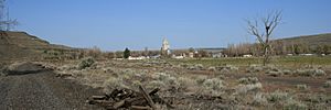
Kahlotus as seen from the Columbia Plateau Trail.
|
|
| Nickname(s):
Hole in The Ground, K-Town
|
|

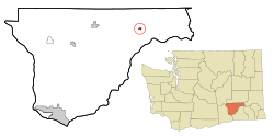
Location of Kahlotus, Washington
|
|
| Country | United States |
| State | Washington |
| County | Franklin |
| Founded | 1890's |
| Incorporated | May 31, 1907 |
| Area | |
| • Total | 0.38 sq mi (0.98 km2) |
| • Land | 0.38 sq mi (0.98 km2) |
| • Water | 0.00 sq mi (0.00 km2) |
| Elevation | 902 ft (275 m) |
| Population
(2020)
|
|
| • Total | 147 |
| • Estimate
(2023)
|
138 |
| • Density | 374.0/sq mi (144.4/km2) |
| Time zone | UTC–8 (Pacific (PST)) |
| • Summer (DST) | UTC–7 (PDT) |
| ZIP Code |
99335
|
| Area code(s) | 509 |
| FIPS code | 53-34575 |
| GNIS feature ID | 1505893 |
| Sales tax | 8.1% |
Kahlotus (/kəˈloʊtəs/) is a small city in Franklin County, Washington, United States. In 2020, about 147 people lived there.
Contents
What's in a Name? The Meaning of Kahlotus
The city was first called Hardersburg. It was named after Hans Harder, who planned the town in 1902. Later, the name changed to Kahlotus.
The meaning of "Kahlotus" is not fully clear. Some believe it comes from a Native American word meaning "Hole in the ground." Others think it might mean "stinking water" or "bad water." This could refer to the salty water in a nearby lake.
Another idea is that the town was named after a Palouse tribal chief. He signed an important agreement called the Yakima Treaty in 1855. His name was spelled in different ways, like Kohlotus or Quillatose.
Kahlotus History: From Railroads to Farming
Early Settlers and Town Growth
The first people to settle in Kahlotus were German immigrants around 1880. They came to work for the railroads. Hans Harder, one of these early settlers, planned the town in 1902. He first named it Hardersburg.
The town's name soon changed to Kahlotus. As mentioned, its meaning is still a bit of a mystery.
Railroad Boom and Development
When Hans Harder planned the town, a railroad line started running again nearby. Soon after, another railroad began building tracks. This second line included tunnels through tall cliffs near Kahlotus lake.
Kahlotus officially became a city on May 31, 1907. The town grew quickly when the railroads were being built. People say there were many businesses, like saloons, a bank, and a newspaper, to serve the railroad workers.
Farming and Water in Kahlotus
For a long time, most of the local economy came from Dryland farming. This means growing crops without much extra water from irrigation. Some farms used water from local wells. The big Columbia Basin Irrigation Project did not bring water to Kahlotus.
In 1969, the Lower Monumental Dam was finished nearby. This brought more electricity and water for farming. However, it also flooded an important ancient site called the Marmes Rockshelter. The dam also made the Snake River easy for boats to travel on. This meant grain could be moved by boat instead of by train.
Changes to the Railroads and Lake
After the dam was built, the railroad tracks through the north end of the valley were removed. Later, in the late 1980s, other railroad tracks near Kahlotus lake were also taken away. This old railroad path became part of the Columbia Plateau Trail State Park.
Kahlotus lake, which was near the town, was once a popular spot for fishing. It was a salty lake fed by springs. Sometimes, the lake would swell with rainwater and flood parts of the town.
However, the lake started to shrink quickly in the 1990s. By 2000, only a small marshy area was left far from town. This likely happened because of several years with less rain and more water being used for farming.
Kahlotus Geography and Climate
Where is Kahlotus Located?
Kahlotus is located at 46°38′42″N 118°33′18″W / 46.64500°N 118.55500°W.
The city covers about 0.98 square kilometers (0.38 square miles) of land. There is no water area within the city limits.
Kahlotus Climate: Semi-Arid Weather
Kahlotus has a semi-arid climate. This means it gets very little rain. It is often dry, but not as dry as a desert.
Kahlotus Population and People
| Historical population | |||
|---|---|---|---|
| Census | Pop. | %± | |
| 1910 | 132 | — | |
| 1920 | 151 | 14.4% | |
| 1930 | 164 | 8.6% | |
| 1940 | 163 | −0.6% | |
| 1950 | 151 | −7.4% | |
| 1960 | 131 | −13.2% | |
| 1970 | 308 | 135.1% | |
| 1980 | 203 | −34.1% | |
| 1990 | 167 | −17.7% | |
| 2000 | 214 | 28.1% | |
| 2010 | 193 | −9.8% | |
| 2020 | 147 | −23.8% | |
| 2023 (est.) | 138 | −28.5% | |
| U.S. Decennial Census 2020 Census |
|||
Population in 2010
In 2010, there were 193 people living in Kahlotus. They lived in 88 households. About 56 of these households were families.
The average age in Kahlotus was 47.8 years old. About 19% of the people were under 18. Around 12% were 65 years or older. The city had slightly more males (53.9%) than females (46.1%).
Kahlotus Economy: Local Jobs
People in the Kahlotus area work in a few main areas. Many are involved in raising cattle and growing wheat. Others work for government groups. These include the Corps of Engineers at the Lower Monumental Dam. They also work at the Lyons Ferry Fish Hatchery and the Coyote Ridge Corrections Facility.
Kahlotus Education: The School District
The Kahlotus School District serves the area. It has always been a small school. The largest graduating class in its history has never been more than 12 students.
The first school building was built in 1916. It was a two-story building that taught all classes until 1954. A new school building was finished in 1954. The school has been updated many times over the years. For example, there were big improvements in the 1990s and 2000s. In 2012, only 2 students graduated from the senior class. In 2013 and 2014, there were 3 graduates each year.
See also
 In Spanish: Kahlotus (Washington) para niños
 | Roy Wilkins |
 | John Lewis |
 | Linda Carol Brown |

