Walla Walla East, Washington facts for kids
Quick facts for kids
Walla Walla East, Washington
|
|
|---|---|

Location of Walla Walla East, Washington
|
|
| Country | United States |
| State | Washington |
| County | Walla Walla |
| Area | |
| • Total | 1.7 sq mi (4.4 km2) |
| • Land | 1.7 sq mi (4.4 km2) |
| • Water | 0.0 sq mi (0.1 km2) |
| Population
(2020)
|
|
| • Total | 2,286 |
| • Density | 1,340/sq mi (520/km2) |
| Time zone | UTC-8 (Pacific (PST)) |
| • Summer (DST) | UTC-7 (PDT) |
| ZIP code |
99362
|
| Area code(s) | 509 |
| FIPS code | 53-75810 |
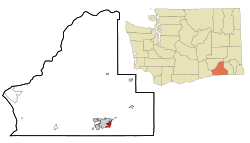
Walla Walla East is a small community in Walla Walla County, Washington, United States. It's called a census-designated place (CDP) because it's a special area defined by the government for counting people. In 2020, about 2,286 people lived there.
Contents
Where is Walla Walla East?
Walla Walla East is located in the southeastern part of Washington. You can find it at these coordinates: 46.058877 degrees north and 118.305585 degrees west.
The community covers a total area of about 1.7 square miles (4.4 square kilometers). Most of this area is land. Only a very small part, about 0.04 square miles (0.1 square kilometers), is water.
Who Lives in Walla Walla East?
The number of people living in Walla Walla East has changed over the years.
- In 2000, there were 2,479 people.
- In 2010, the population was 1,672.
- By 2020, it grew to 2,286 people.
In 2000, there were 947 households in Walla Walla East. A household is a group of people living together in one home. Most households (about 66.8%) were married couples. About 32.7% of households had children under 18 living with them.
The average age of people in Walla Walla East in 2000 was 42 years old. About 24.4% of the population was under 18.
Schools in Walla Walla East
Children living in Walla Walla East go to schools that are part of the Walla Walla Public Schools district. This district serves the areas east of the city of Walla Walla.
See also
 | Frances Mary Albrier |
 | Whitney Young |
 | Muhammad Ali |

