
Multnomah Falls facts for kids
Quick facts for kids Multnomah Falls |
|
|---|---|

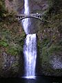
Full view of both tiers of the falls
|
|
| Lua error in Module:Infobox_mapframe at line 185: attempt to index field 'wikibase' (a nil value). | |
| Location | Columbia River Gorge, Multnomah County, Oregon, U.S. |
| Coordinates | 45°34′33″N 122°06′55″W / 45.57595°N 122.11536°W |
| Type | Tiered |
| Elevation | 627 ft (191 m) |
| Total height | 620 ft (189 m) |
| Number of drops | 2 |
| Longest drop | 542 ft (165 m) |
| Average width | 10 ft (3 m) |
| Watercourse | Multnomah Creek |
| Average flow rate |
150 cu ft/s (4.2 m3/s) |
| World height ranking | 434 |
Multnomah Falls is a famous waterfall in Oregon, United States. It is located on Multnomah Creek in the beautiful Columbia River Gorge. You can easily reach it from the Historic Columbia River Highway and Interstate 84.
This amazing waterfall has two parts, or "tiers," that drop over basalt cliffs. It is the tallest waterfall in Oregon, standing at about 620 ft (189 m) (189 meters) high! A bridge called the Multnomah Creek Bridge, built in 1914, crosses below the falls. This bridge is a historic landmark.
In the early 1900s, a man named Simon Benson helped develop the area around the falls. A pathway, a viewing bridge, and a lodge were built in 1925. The Multnomah Falls Lodge and its paths became historic places in 1981. Today, Oregon maintains a winding trail that goes up to a high viewing spot. More than two million people visit Multnomah Falls every year. This makes it the most-visited natural spot in the U.S. Pacific Northwest.
Contents
How Tall is Multnomah Falls?
Multnomah Falls drops in two main sections. The upper part is about 542 feet (165 m) (165 meters) tall. The lower part is about 69 feet (21 m) (21 meters) tall. There is a small 9-foot (3-meter) drop between the two sections. This is why the total height is usually given as 620 feet (189 m) (189 meters). The two drops happen because of a type of rock called basalt that wears away easily.
Multnomah Falls is the tallest waterfall in the state of Oregon. Signs at the falls and the United States Forest Service say it is the second tallest waterfall in the United States that flows all year. However, some people question this. The World Waterfall Database lists it as the 156th tallest waterfall in the U.S.
Where Does the Water Come From?
The water for Multnomah Falls comes from underground springs on Larch Mountain. These springs provide water all year long. In spring, melting snow from the mountain adds more water. Rainwater also helps keep the falls flowing during other seasons. This spring is the start of Multnomah Creek.
Multnomah Creek flows into Benson Lake. This lake is about 1,300 feet (400 meters) west of the bottom of the falls.
History of Multnomah Falls
How the Falls Formed
The waterfall formed about 15,000 years ago. It was created by huge floods called the Missoula floods. These floods carved out the landscape.
The Multnomah tribe, who gave the falls its name, have a special story about its creation. They say a young woman sacrificed herself to the Great Spirit. She jumped from the cliff to save her village from a terrible plague. After she jumped, water began to flow from the cliff, creating the waterfall. This saved the Multnomah people.
Explorers William Clark and Meriwether Lewis saw the falls during their expedition in 1805. William Clark wrote about seeing "4 Cascades" (waterfalls) in his journal.
Building the Lodge and Bridge
|
Multnomah Falls Lodge and Footpath
|
|
 |
|
| Location | c. Bridal Veil, Oregon |
|---|---|
| Nearest city | Cascade Locks, Oregon |
| Built | 1915 |
| Architect | A.E. Doyle |
| NRHP reference No. | 81000512 |
| Added to NRHP | April 22, 1981 |
.jpg)
In 1915, Samuel C. Lancaster suggested building a trail from the falls to the top of Larch Mountain. Local groups and financier Simon Benson helped pay for it. Benson also paid Italian stonemasons to build a bridge at the falls.
This bridge is called the Benson Footbridge. It crosses the lower falls about 105 feet (32 m) (32 meters) high. From the bridge, visitors get a great view of the upper falls.
In 1915, Simon Benson gave over 1,400 acres (570 ha) of land, including the falls, to the city of Portland. The Oregon Railroad and Navigation Company also donated land. They agreed that a lodge would be built there.
The Multnomah Falls Lodge was designed by architect A. E. Doyle. It was finished in 1925. The lodge was built using local stone and cedar wood. In the past, it offered meals and places to stay for travelers. Today, it has a restaurant, a gift shop, and a visitor center. The lodge and its paths were added to the National Register of Historic Places in 1981.
Visiting Multnomah Falls
_-_09.JPG)

Multnomah Falls is easy to reach from Interstate 84. It is a "designated scenic area" in Oregon. It is the most-visited natural recreation area in the Pacific Northwest. Over two million people visit each year. There is a rest area and a tunnel under the road. This lets travelers stop and visit the falls easily.
During summer and holidays, the parking lot can fill up fast. When it's full, a sign on the freeway tells drivers. You can also take shuttle buses or ebike tours to the falls.
Walking the Footpaths
A paved trail leads to the Benson Footbridge. This bridge is 45 feet (14 m)-long and crosses 105 feet (32 m) above the lower waterfall. From the bridge, you can see the upper falls.
The trail continues to climb higher. It has eleven switchbacks (zig-zag turns). It reaches an observation deck that looks over the edge of the falls. From here, you get a bird's-eye view of the Columbia Gorge. You can also see "Little Multnomah," a small waterfall upstream that isn't visible from the ground.
There are other trails that connect to the main path. You can take a 5.4 miles (8.7 km) loop trail to other nearby waterfalls. The Mark O. Hatfield Memorial Trail also starts at the falls. It goes through the Oregon side of the Columbia River Gorge.
Concerns and Repairs
In 1991, a wildfire damaged over 1,600 acres (650 ha) near the falls. This caused some hiking trails to close permanently.
In September 1995, a huge 400-ton boulder fell from the waterfall. It landed in the pool above Benson Footbridge. This caused a 70-foot (21 m) splash of water and rocks. Twenty people on the bridge were slightly injured.
In January 2014, a falling rock damaged part of the bridge walkway. The Forest Service closed the bridge for repairs.
In September 2017, the Eagle Creek Fire threatened the lodge. The lodge and falls access were closed. The lodge reopened in November 2017. However, the footpaths remained closed for a while due to concerns about landslides. The trail to the Benson Bridge reopened in June 2018. Other trails in the area were repaired and reopened in November 2018.
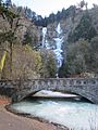
Multnomah Creek Bridge
The Multnomah Creek Bridge was built in 1914. It is a stone bridge that carries the Historic Columbia River Highway across Multnomah Creek. It is 67 feet (20 m) long. This bridge is an important part of the highway's listing on the National Register of Historic Places.
Images for kids
-
Multnomah Creek Bridge
-
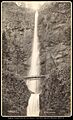
Original timber truss bridge built by the Oregon Railway and Navigation Company, around 1888
-
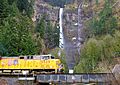
A Union Pacific Railroad train passing the falls
-
Bridge built over the falls
-
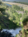
Top of Multnomah Falls with lodge and parking lot visible, along with I-84 and the Columbia River
_-_29.JPG)

.jpg)

.png)
See also
 In Spanish: Multnomah Falls para niños
