
Larch Mountain (Multnomah County, Oregon) facts for kids
Quick facts for kids Larch Mountain |
|
|---|---|

Larch Mountain, as seen from Washougal, Washington.
|
|
| Highest point | |
| Elevation | 4,061 ft (1,238 m) NAVD 88 |
| Prominence | 975 ft (297 m) |
| Geography | |
| Location | Multnomah County, Oregon, U.S. |
| Topo map | USGS Multnomah Falls |
| Geology | |
| Age of rock | 1.8–1.4 Ma |
| Mountain type | Shield volcano |
| Volcanic field | Boring Lava Field |
| Last eruption | 1.4 Ma |
| Climbing | |
| Easiest route | paved road (June–October) hiking trails (November–May) |

Larch Mountain is an extinct volcano located near Portland, in Oregon. Even though it's called "Larch Mountain," you won't find any real western larch trees there. Early loggers sold noble fir wood as larch, which is how the mountain got its name.
You can reach the top of Larch Mountain by car from May to November. The paved Larch Mountain Road is about 16 miles (26 km) east of Corbett, Oregon. During winter and spring, the road closes due to snow. The road from the Historic Columbia River Highway is 14 miles (23 km) long. It usually closes at milepost 10 from November through late May or early June.
Contents
Exploring Larch Mountain's Location
Larch Mountain is in Multnomah County, Oregon. It sits about 40 miles (64 km) east of Portland. The mountain is located above the famous Columbia River Gorge.
How High is Larch Mountain?
Larch Mountain stands at 4,061 feet (1,238 meters) tall. However, it only rises about 975 feet (297 meters) above the land around it. This is called its "prominence."
Getting to the Summit
You can drive to the mountain's summit on Larch Mountain Road. This road is open from May to November. It branches off the Historic Columbia River Highway about 2 miles (3.2 km) east of Corbett. The road closes at milepost 10 during winter. This is because driving on the upper slopes can be dangerous in snowy weather.
The Story of Larch Mountain
In 1879, a man named Amos James Moore first suggested logging Larch Mountain. The mountain was attractive because it was close to Portland and the Columbia River. It had some of the best cedar, hemlock, and fir trees in the United States.
Early Logging and Mills
In 1886, the Bridal Veil Lumbering Company began logging. They built a lumber mill. A year later, the Latourrel Falls Wagon Road and Lumber Company also started operations. Logging grew quickly when a wooden plank road was built. This road went from Larch Mountain to the railroad line near the river. This allowed for large amounts of timber to be moved. The Bridal Veil Lumbering company became known for its high-quality wood.
Fires and Changes in Logging
In 1902, a fire destroyed one of the mills and the nearby town. Both were soon rebuilt in new places. This fire marked a turning point. It led to the end of the old-fashioned, large-scale logging methods. Newer, more modern techniques took their place. Only a few parts of the old system remain today. Logging continued on the mountain for several more decades using these new methods.
In 1928, the United States Forest Service started planting new trees on Larch Mountain. This was done to help produce more lumber in the future. A fire in 1936 finally ended the timber business on the mountain. This fire caused about $100,000 in damage. It badly hurt the lumber mill, which was not rebuilt. This was because there were not enough trees left to make it worth rebuilding.
Larch Mountain's Volcanic Past
Larch Mountain is what's left of an ancient shield volcano. Shield volcanoes have wide, gentle slopes. This volcano's slopes cover many square miles. It is currently the tallest peak in the Boring Lava Field. This is a group of volcanoes that were active long ago.
When Larch Mountain Was Active
Larch Mountain was active between 1.8 and 1.4 million years ago. It is mostly made of a type of rock called basalt. However, the very top, at Sherrard Point, is made of iron-rich andesite. It can be hard to tell Larch Mountain's basalt apart from the surrounding Columbia River Basalt. But the Columbia River Basalt is a bit lighter in color and less easily broken. Sherrard Point is the worn-down remains of the volcano's original volcanic plug.
How Glaciers Shaped the Mountain
Sherrard Point became visible during the last glacial period. At that time, most of the mountain's peak was destroyed by huge sheets of ice called glaciers. The glaciers carved a large bowl-shaped hollow, called a cirque, into the mountain. This cirque then filled with water, forming a large lake. Over time, the lake filled with dirt and rocks. Today, that area is a big meadow.
Nature and Wildlife at Larch Mountain
Larch Mountain has some of the biggest old-growth forests left in the Columbia River Gorge area. These forests are special because they have many nurse logs. Nurse logs are fallen trees that help new plants grow.
Trees You Can Find Here
The main types of trees in these forests include pacific silver fir, grand fir, Douglas fir, and western hemlock. These tall, old trees make the forest a unique place.
Fun Things to Do at Larch Mountain
The Larch Mountain area has many popular hiking trails. These trails are great for exploring the outdoors.
Popular Hiking Trails
The Larch Mountain Trail #441 starts near the Columbia River. It begins at the Multnomah Falls Lodge. The trail generally follows Multnomah Creek. Along the way, you'll pass several beautiful waterfalls. These include the famous Multnomah Falls, Weisendanger Falls, and Ecola Falls. The trail ends at the Larch Mountain parking lot, where there's a picnic area.
Sherrard Point Viewpoint
From the picnic area, the Sherrard Point Trail #443 leads to Sherrard Point. This is the very top of the mountain. Sherrard Point offers amazing views of the nearby Cascade Range volcanoes. You can see Mount Hood, Mount Adams, Mount Jefferson, Mount Rainier, and Mount St. Helens. There are special plaques that show the height of each volcano.
Loop Trails
You can also hike a loop around Larch Mountain itself. This loop is made up of three trails: the Larch Mountain Trail, the Multnomah Creek Way Trail #444, and the Oneonta Trail #424.
Images for kids
-
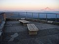
View from the summit with Mount Hood in the distance.
-
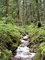
A creek in Larch Mountain forest.
-
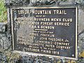
Larch Mountain Trail plaque
-
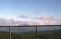
View of Mt St Helens from the summit of Larch Mountain


