
Cascade Locks, Oregon facts for kids
Quick facts for kids
Cascade Locks, Oregon
|
|
|---|---|

Former locks on the Columbia River, with the modern Bridge of the Gods in the background
|
|

Location in Oregon
|
|
| Country | United States |
| State | Oregon |
| County | Hood River |
| Incorporated | 1935 |
| Area | |
| • Total | 3.03 sq mi (7.85 km2) |
| • Land | 2.08 sq mi (5.40 km2) |
| • Water | 0.95 sq mi (2.46 km2) |
| Elevation | 151 ft (46 m) |
| Population
(2020)
|
|
| • Total | 1,530 |
| • Density | 661.39/sq mi (255.42/km2) |
| Time zone | UTC-8 (Pacific) |
| • Summer (DST) | UTC-7 (Pacific) |
| ZIP code |
97014
|
| Area code(s) | 541 and 458 |
| FIPS code | 41-11600 |
| GNIS feature ID | 2409403 |

Cascade Locks is a small city in Hood River County, Oregon, in the United States. It got its name from special structures called "locks" that were built to help boats travel past the fast-moving Cascades Rapids on the Columbia River.
The U.S. government approved the plan for these locks in 1875. Construction started in 1878, and they were finished on November 5, 1896. Later, in 1938, the locks were covered by water when the Bonneville Dam was built. This dam created a large lake called Lake Bonneville. Even though the old locks are now underwater, the city of Cascade Locks did not lose any land.
In 2010, about 1,144 people lived in Cascade Locks. By 2020, the population grew to 1,530.


Cascade Locks is located just before the Bridge of the Gods. This is a toll bridge that goes across the Columbia River. It's the only bridge over the Columbia River between the big cities of Portland and Hood River.
The city is also a few miles upstream from Eagle Creek Gorge. This is a very beautiful area and is also an alternative path for the famous Pacific Crest Trail. Many hikers on the Pacific Crest Trail use Cascade Locks to cross the Columbia River. It's the lowest point on the trail, which stretches all the way from the Mexico-US border to the Canada-US border.
Since 1999, the Confederated Tribes of Warm Springs have been looking into building a casino in Cascade Locks. Also, city officials tried to make a deal to sell city water to a company for bottling. However, in May 2016, voters in Hood River County decided to stop this water bottling project.
Contents
Geography of Cascade Locks
Cascade Locks is in the northwest part of Hood River County. It sits on the south side of the Columbia River. Across the river to the north is Skamania County, Washington. The city of Stevenson, Washington, is also north of Cascade Locks, just across the river.
How to Get Around
U.S. Route 30 goes right through the middle of Cascade Locks. You can also reach the city from Interstate 84 at exits labeled "44." Both US 30 and I-84 can take you east about 19 miles to Hood River or west about 43 miles to Portland.
US 30 also leads to the Bridge of the Gods. This toll bridge crosses the Columbia River and connects Oregon to Washington State Route 14 in Washington.
City Size
The city of Cascade Locks covers a total area of about 3.04 square miles (7.85 square kilometers). About 2.08 square miles (5.40 square kilometers) of this is land, and 0.96 square miles (2.46 square kilometers) is water.
Climate in Cascade Locks
Cascade Locks has a climate with warm, dry summers. The average monthly temperatures don't go above 71.6 degrees Fahrenheit (22 degrees Celsius). This type of weather is called a "warm-summer Mediterranean climate." The city gets a lot of rain, with an average of about 76 inches (193 cm) of precipitation each year.
People in Cascade Locks
| Historical population | |||
|---|---|---|---|
| Census | Pop. | %± | |
| 1940 | 703 | — | |
| 1950 | 733 | 4.3% | |
| 1960 | 660 | −10.0% | |
| 1970 | 574 | −13.0% | |
| 1980 | 838 | 46.0% | |
| 1990 | 930 | 11.0% | |
| 2000 | 1,115 | 19.9% | |
| 2010 | 1,144 | 2.6% | |
| 2020 | 1,427 | 24.7% | |
| U.S. Decennial Census | |||
Population in 2010
In 2010, there were 1,144 people living in Cascade Locks. There were 445 households, which are groups of people living together in one home.
Most of the people in the city were White (87.7%). There were also smaller groups of people from other backgrounds, including Native American, Asian, and African American. About 9.1% of the population was Hispanic or Latino.
The average age of people in the city was about 40.8 years old. About 20.8% of the residents were under 18 years old, and 11.5% were 65 years or older. The city had slightly more males (51.5%) than females (48.5%).
Transportation
- Cascade Locks State Airport is a small airport located in the city.
The Historic Columbia River Highway (US 30) runs through Cascade Locks. You can get to it from I-84 at exit 44. The Bridge of the Gods connects Cascade Locks to Washington State Route 14 in Washington.
Local and intercity bus services are provided by Columbia Area Transit and Skamania County Transit. These buses help people travel to nearby communities.
Images for kids
-
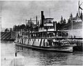
A sternwheeler boat called J.N. Teal in Cascade Locks in 1911. You can see old cars on the front of the boat!
-
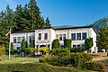
The city hall building in Cascade Locks.
-
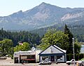
The post office in Cascade Locks, with the wide Columbia River in the background.
See also
 In Spanish: Cascade Locks para niños
