
Vernonia, Oregon facts for kids
Quick facts for kids
Vernonia, Oregon
|
||
|---|---|---|

Downtown Vernonia
|
||
|
||

Location in Oregon
|
||
| Country | United States | |
| State | Oregon | |
| County | Columbia | |
| Incorporated | 1891 | |
| Area | ||
| • Total | 1.69 sq mi (4.38 km2) | |
| • Land | 1.64 sq mi (4.25 km2) | |
| • Water | 0.05 sq mi (0.13 km2) | |
| Elevation | 774 ft (236 m) | |
| Population
(2020)
|
||
| • Total | 2,374 | |
| • Density | 1,444.92/sq mi (558.05/km2) | |
| Time zone | UTC-8 (Pacific) | |
| • Summer (DST) | UTC-7 (Pacific) | |
| ZIP code |
97064
|
|
| Area code(s) | 503 and 971 | |
| FIPS code | 41-77250 | |
| GNIS feature ID | 2412152 | |
| Website | www.vernonia-or.gov | |
Vernonia is a small city in Columbia County, Oregon, USA. It sits by the Nehalem River in a valley. This area is known for its important timber industry, which has been a big part of Vernonia's history. In 2010, about 2,151 people lived here.
Contents
History of Vernonia
-
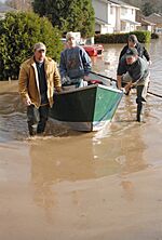
Vernonia during the 2007 flooding
-
View of the Shay locomotive in Shay Park along Rock Creek in Vernonia


The first people to settle here were the Parker and Van Blaricom families in 1874. Later, in 1876, cousins Judson Weed and Ozias Cherrington arrived from Ohio. They decided to name the community after Cherrington's daughter, Vernona, who lived in Ohio. However, when the town officially became a city, a mistake was made, and an "i" was added to the name, making it Vernonia. Sadly, Cherrington passed away in 1894 and never saw his daughter again after leaving Ohio.
Vernonia began to grow a lot on July 10, 1924. This was when the Oregon-American Lumber Company opened a very modern lumber mill. A railroad line was also built, connecting Vernonia to the rest of the country. This made it easier to transport timber. The mill changed owners a few times and finally closed on December 20, 1957.
The city has faced big floods many times. In 1996, heavy rains caused the Willamette Valley Flood of 1996, which also flooded Vernonia. Some homes were raised to protect them, and different flooring was used to help with future floods. In 2007, more strong storms hit the area. These storms washed out roads and damaged homes, cars, and communication systems. Even with the changes made in 1996, some parts of town were flooded by water that was 4 feet (1.2 m) higher than expected.
After the 2007 flood, people in the Vernonia School District voted in 2009 to approve a $13 million bond. This money was used to build a new school for students from kindergarten through 12th grade. The new school opened in the fall of 2012.
Community Events
The Friendship Jamboree is a yearly event that started in 1957. It is held on the first full weekend of August.
Geography of Vernonia
The United States Census Bureau says that Vernonia covers about 1.66 square miles (4.30 square kilometers). Most of this area, about 1.61 square miles (4.17 square kilometers), is land. The rest, about 0.05 square miles (0.13 square kilometers), is water.
Climate in Vernonia
Vernonia has a climate where summers are warm but not too hot, and they are also dry. The average monthly temperature never goes above 71.6°F (22°C). This type of weather is called a warm-summer Mediterranean climate, or "Csb" on climate maps.
| Climate data for Vernonia, Oregon, 1991–2020 normals, extremes 1967–present | |||||||||||||
|---|---|---|---|---|---|---|---|---|---|---|---|---|---|
| Month | Jan | Feb | Mar | Apr | May | Jun | Jul | Aug | Sep | Oct | Nov | Dec | Year |
| Record high °F (°C) | 66 (19) |
72 (22) |
79 (26) |
89 (32) |
99 (37) |
111 (44) |
104 (40) |
103 (39) |
103 (39) |
93 (34) |
73 (23) |
64 (18) |
111 (44) |
| Mean maximum °F (°C) | 55.2 (12.9) |
60.7 (15.9) |
68.3 (20.2) |
76.9 (24.9) |
84.7 (29.3) |
88.0 (31.1) |
93.4 (34.1) |
94.1 (34.5) |
89.4 (31.9) |
77.3 (25.2) |
61.7 (16.5) |
54.1 (12.3) |
97.4 (36.3) |
| Mean daily maximum °F (°C) | 45.7 (7.6) |
49.4 (9.7) |
53.6 (12.0) |
58.6 (14.8) |
65.5 (18.6) |
69.9 (21.1) |
77.3 (25.2) |
78.2 (25.7) |
73.1 (22.8) |
61.4 (16.3) |
50.6 (10.3) |
44.3 (6.8) |
60.6 (15.9) |
| Daily mean °F (°C) | 38.7 (3.7) |
40.2 (4.6) |
43.5 (6.4) |
47.1 (8.4) |
52.9 (11.6) |
57.2 (14.0) |
62.3 (16.8) |
62.5 (16.9) |
58.0 (14.4) |
49.8 (9.9) |
42.4 (5.8) |
37.8 (3.2) |
49.4 (9.6) |
| Mean daily minimum °F (°C) | 31.6 (−0.2) |
30.9 (−0.6) |
33.5 (0.8) |
35.6 (2.0) |
40.3 (4.6) |
44.4 (6.9) |
47.2 (8.4) |
46.9 (8.3) |
42.9 (6.1) |
38.3 (3.5) |
34.2 (1.2) |
31.3 (−0.4) |
38.1 (3.4) |
| Mean minimum °F (°C) | 18.5 (−7.5) |
19.7 (−6.8) |
24.1 (−4.4) |
27.4 (−2.6) |
30.7 (−0.7) |
35.3 (1.8) |
38.5 (3.6) |
37.7 (3.2) |
32.9 (0.5) |
25.8 (−3.4) |
21.6 (−5.8) |
18.6 (−7.4) |
12.4 (−10.9) |
| Record low °F (°C) | −2 (−19) |
−6 (−21) |
13 (−11) |
22 (−6) |
27 (−3) |
30 (−1) |
33 (1) |
32 (0) |
23 (−5) |
10 (−12) |
2 (−17) |
−7 (−22) |
−7 (−22) |
| Average precipitation inches (mm) | 6.94 (176) |
5.34 (136) |
5.30 (135) |
3.74 (95) |
2.39 (61) |
1.44 (37) |
0.39 (9.9) |
0.55 (14) |
1.79 (45) |
4.12 (105) |
7.70 (196) |
8.33 (212) |
48.03 (1,221.9) |
| Average snowfall inches (cm) | 0.3 (0.76) |
0.6 (1.5) |
0.0 (0.0) |
0.0 (0.0) |
0.0 (0.0) |
0.0 (0.0) |
0.0 (0.0) |
0.0 (0.0) |
0.0 (0.0) |
0.0 (0.0) |
0.0 (0.0) |
0.2 (0.51) |
1.1 (2.77) |
| Average precipitation days (≥ 0.01 in) | 20.0 | 16.8 | 19.5 | 17.4 | 12.4 | 9.5 | 3.7 | 3.5 | 7.8 | 14.8 | 19.8 | 20.0 | 165.2 |
| Average snowy days (≥ 0.1 in) | 0.2 | 0.2 | 0.0 | 0.0 | 0.0 | 0.0 | 0.0 | 0.0 | 0.0 | 0.0 | 0.0 | 0.1 | 0.5 |
| Source 1: NOAA | |||||||||||||
| Source 2: National Weather Service | |||||||||||||
Vernonia Population Data
| Historical population | |||
|---|---|---|---|
| Census | Pop. | %± | |
| 1900 | 62 | — | |
| 1910 | 69 | 11.3% | |
| 1920 | 142 | 105.8% | |
| 1930 | 1,625 | 1,044.4% | |
| 1940 | 1,412 | −13.1% | |
| 1950 | 1,521 | 7.7% | |
| 1960 | 1,089 | −28.4% | |
| 1970 | 1,643 | 50.9% | |
| 1980 | 1,785 | 8.6% | |
| 1990 | 1,808 | 1.3% | |
| 2000 | 2,228 | 23.2% | |
| 2010 | 2,151 | −3.5% | |
| 2020 | 2,374 | 10.4% | |
| U.S. Decennial Census | |||
Vernonia Population in 2010
According to the census from 2010, there were 2,151 people living in Vernonia. These people lived in 822 households, and 571 of these were families. The city had about 1,336 people per square mile (516 people per square kilometer). There were 962 housing units, with about 598 housing units per square mile (231 per square kilometer).
Most of the people in the city (94.1%) were White. Smaller groups included African American (0.3%), Native American (1.3%), Asian (0.5%), and Pacific Islander (0.2%). About 0.8% were from other races, and 2.8% were from two or more races. People who identified as Hispanic or Latino made up 4.2% of the population.
Out of the 822 households:
- 35.5% had children under 18 living with them.
- 52.6% were married couples living together.
- 11.1% had a female head of household with no husband present.
- 5.8% had a male head of household with no wife present.
- 30.5% were not families.
About 25.7% of all households were made up of single individuals. Also, 8.9% had someone living alone who was 65 years old or older. On average, there were 2.61 people per household and 3.09 people per family.
The average age of people in the city was 38.2 years.
- 26.9% of residents were under 18 years old.
- 7.8% were between 18 and 24 years old.
- 25.3% were between 25 and 44 years old.
- 29.2% were between 45 and 64 years old.
- 10.8% were 65 years or older.
The city's population was 51.0% male and 49.0% female.
Getting Around Vernonia
Oregon Route 47 is the main highway that serves Vernonia. It connects the city to the lower Columbia River and U.S. Route 30 to the north. It also links to U.S. Route 26 to the south.
Trails for Fun
The Banks–Vernonia State Trail is a special path built on old railroad lines. It's 21 miles (34 km) long and is great for bicyclists, walkers, and horseback riders. It runs mostly next to Route 47 south of Vernonia.
Another trail is the Crown Zellerbach trail. This trail was made from old logging roads, which were once old railroad tracks. It's perfect for mountain biking, hiking, and horseback riding. This trail stretches over 20 miles (32 km) from Vernonia to Scappoose. In 2023, it was named a National Recreation Trail, becoming part of the National Trails System.
Public Transportation
There is limited public transit service in Vernonia. It's called the Columbia County Rider (or CC Rider) and is run by the county's Transit Division. This bus service connects Vernonia to the Willow Creek MAX light rail station and bus center in Hillsboro. The bus route, called the Nehalem Valley Fixed-Route Service, started on July 1, 2009. It currently runs on Mondays, Wednesdays, and Fridays, with two trips each day.
Vernonia Municipal Airport
The Vernonia Municipal Airport (FAA: 05S) is an airport owned by the city. It is open for public use and is located about 2 nautical miles (3.7 km) west of the main part of Vernonia.
See also
 In Spanish: Vernonia (Oregón) para niños
