Nehalem River facts for kids
Quick facts for kids Nehalem River |
|
|---|---|

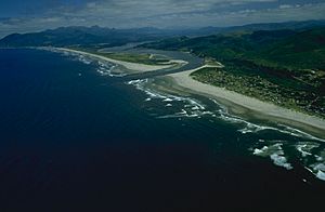
Nehalem Bay at the mouth of the Nehalem River on the Pacific Ocean
|
|
|
Location of the mouth of the Nehalem River in Oregon
|
|
| Country | United States |
| State | Oregon |
| County | Washington, Columbia, Clatsop, Tillamook |
| Physical characteristics | |
| Main source | Northern Oregon Coast Range Giveout Mountain, Tillamook County, Oregon 2,424 ft (739 m) 45°43′53″N 123°25′26″W / 45.73139°N 123.42389°W |
| River mouth | Nehalem Bay near Nehalem, Tillamook County, Oregon 0 ft (0 m) 45°39′29″N 123°56′04″W / 45.65806°N 123.93444°W |
| Length | 118.5 mi (190.7 km) |
| Basin features | |
| Basin size | 855 sq mi (2,210 km2) |
The Nehalem River is a river in Oregon, United States. It flows for about 119 miles (191 km) to the Pacific Ocean. This river is found on the northwest coast of Oregon. It starts in the Northern Oregon Coast Range mountains. The Nehalem River's water basin covers about 855 square miles (2,210 km²). This area was once important for the timber industry. It was also the location of the Tillamook Burn, a series of large forest fires. The river flows through small towns in its upper parts. But it is mostly empty of people closer to the coast.
Journey of the Nehalem River
The Nehalem River begins in the northeast part of Tillamook County. It starts in the Tillamook State Forest. The river first flows northeast. It crosses into Washington County and then into Columbia County.
It passes by the town of Vernonia. Here, it meets Rock Creek. The river then turns northwest and west into Clatsop County. After that, it flows southwest back into northern Tillamook County. Finally, the Nehalem River reaches Nehalem Bay and the Pacific Ocean. This happens in an estuary near the town of Nehalem. This spot is about 70 miles (110 km) west-northwest of Portland. Close to the ocean, the river flows under U.S. Route 101.
River Branches and Connections
The Nehalem River has several important branches. The Salmonberry River joins it from the east. This happens in northern Tillamook County.
Another branch is the North Fork Nehalem River. This fork joins the main river about 25 miles (40 km) from the north. It connects just before the Nehalem River enters Nehalem Bay.
The Salmonberry Bridge Story
In 2007, a very big storm hit the area. This storm caused the Salmonberry Bridge to fall down. The bridge was an important crossing over the Salmonberry River.
It took some time, but the bridge was rebuilt. It was opened again for traffic on May 14, 2012. This showed how communities work together to fix important structures after natural events.
 | Leon Lynch |
 | Milton P. Webster |
 | Ferdinand Smith |


