Grand Ronde Community facts for kids
Quick facts for kids
Grand Ronde Community
|
|
|---|---|

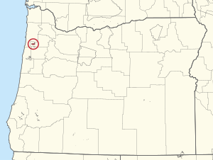
Location of Grand Ronde Community within Oregon
|
|
| Tribe | Confederated Tribes of the Grand Ronde Community of Oregon |
| Country | United States |
| State | Oregon |
| County | |
| Area | |
| • Total | 42.43 km2 (16.384 sq mi) |
| Population
(2000)
|
|
| • Total | 55 |
The Grand Ronde Community is a special area of land called an Indian reservation. It's located in Oregon, USA, across parts of Yamhill County and Polk County. This land is about 18 miles (29 km) east of Lincoln City, near the town of Grand Ronde.
In the mid-1800s, the United States government made many different Native American tribes and groups from Western Oregon leave their homes. They were forced to move to this reservation. Today, the Grand Ronde Community is managed by the Confederated Tribes of the Grand Ronde Community of Oregon. The reservation covers about 16.384 square miles (42.43 km2). In the year 2000, 55 people lived on the reservation. However, many members of the tribe live in other places to find jobs.
Contents
Where is Grand Ronde?
The Grand Ronde Reservation is found at these coordinates: 45°08′50″N 123°38′44″W / 45.14722°N 123.64556°W. It's in a beautiful part of Oregon.
A Look Back at Grand Ronde's History
Early Life and Treaties
For thousands of years, long before 6,000 BC, many different Native American peoples lived in this area. These included the Rogue River, Umpqua, Chasta, Kalapuya, Molalla, Salmon River, Tillamook, and Nestucca tribes. They lived on their traditional lands.
Between 1854 and 1857, the Grand Ronde reservation was created. This happened after the Rogue River Wars. The U.S. government made agreements called treaties in 1854 and 1855. An official order on June 30, 1857, also helped establish the reservation. In 1856, a place called Fort Yamhill was built next to the reservation.
Changes to Tribal Land
In 1887, a law called the General Allotment Act was passed. This law divided the reservation land into smaller pieces for individual Native Americans. About 33,000 acres (130 km2) of reservation land were given out this way. Sadly, most of this land ended up being owned by people who were not Native American.
Later, in 1901, a U.S. Inspector said that 25,791 acres (104.37 km2) of the reservation were "extra" land. The U.S. government then sold this land for a very low price.
Rebuilding and Recognition
In 1936, the Indian Reorganization Act helped the tribe. This act allowed them to buy back some land for homes. This was a step towards getting their land back.
However, in 1954, a new policy called the Termination Act ended the tribe's official status with the federal government. This meant the tribe lost many of its rights and protections.
Fortunately, this changed in 1983. On November 22, 1983, President Ronald Reagan signed the Grand Ronde Restoration Act. This important act officially recognized the people as a tribe again. It was a huge step for the community.
By 1988, the tribe got back 9,811 acres (39.70 km2) of their land. Today, they have about 10,052 acres (40.68 km2). This shows how the tribe has worked hard to regain their heritage and land.
 | Emma Amos |
 | Edward Mitchell Bannister |
 | Larry D. Alexander |
 | Ernie Barnes |

