Grand Ronde, Oregon facts for kids
Quick facts for kids
Grand Ronde, Oregon
|
|
|---|---|
|
Census-designated place (CDP)
|
|

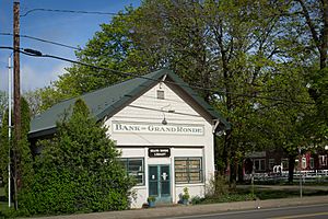
The Grand Ronde Public Library
|
|

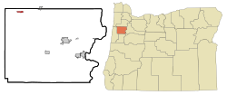
Location of Grand Ronde within Polk County, Oregon
|
|
| Country | United States |
| State | Oregon |
| County | Polk & Yamhill |
| Area | |
| • Total | 19.20 sq mi (49.72 km2) |
| • Land | 19.20 sq mi (49.72 km2) |
| • Water | 0.00 sq mi (0.00 km2) |
| Elevation | 338 ft (103 m) |
| Population
(2020)
|
|
| • Total | 2,010 |
| • Density | 104.70/sq mi (40.43/km2) |
| Time zone | UTC-8 (Pacific (PST)) |
| • Summer (DST) | UTC-7 (PDT) |
| ZIP code |
97347
|
| Area code(s) | 503 |
| FIPS code | 41-30300 |
| GNIS feature ID | 2408316 |
Grand Ronde is a community in Polk and Yamhill counties, Oregon, United States. It is known as a census-designated place (CDP), which means it's an area defined by the government for collecting population data.
The name "Grand Ronde" comes from the French words Grande Ronde, meaning "Grand Round." This name might refer to the large gathering of Native American people who were settled on the Grand Ronde Indian Reservation. It could also describe the round shape of the valley where the community is located. In 2010, about 1,661 people lived in Grand Ronde. It is part of the larger Salem Metropolitan Statistical Area.
Contents
History of Grand Ronde
Early Native American Settlements
In 1855, a special agreement was made between different groups of Kalapuyan Native Americans and the Oregon Superintendent of Indian Affairs, Joel Palmer. This agreement, called a treaty, asked the Kalapuyan groups to move to a new area set aside by the government.
This new area became the Grand Ronde Indian Reservation. It opened in 1857 and covered a large area of land in Polk and Yamhill counties.
Growth of the Town
The town of Grand Ronde started around 1908. It was first called "New Grand Ronde." This was when many Native American families began to leave the reservation. They started their own farms and ranches under a law called the Dawes Act.
In 1921, a company named International Harvester helped plan the town. The next year, they built a nine-mile railroad track. This track connected Grand Ronde to another town called Willamina. The railroad helped the timber industry grow, making lumber mills very important to the area's economy.
Grand Ronde became a busy center for people working in the mills. It had a train station, a store, a hotel, a movie theater, a diner, a gas station, a bank, a post office, and a church. People also built homes there.
Lumber Industry and Electricity
The Spaulding-Miami Lumber Company owned and developed the town in the early 1920s. They built the railroad line and other buildings for their logging work. Electricity came to Grand Ronde in 1922, which was a big step for the community.
Modern Grand Ronde and Community Support
Today, the Confederated Tribes of the Grand Ronde Community are very important to the area. They own and run the Spirit Mountain Casino. This casino is a major employer, meaning it provides many jobs for local people.
In 1997, the casino started the Spirit Mountain Community Fund. This fund uses money from the casino's earnings to help many charities. These charities support communities in Polk County and all over Oregon. In 2010, the Grand Ronde area officially grew to include parts of Yamhill County.
How the Name Became Official
For many years, there was talk about how to spell the town's name. Starting in 1919, officials discussed if it should be "Grande Ronde" (the French spelling) or "Grand Ronde." After much research, the name "Grand Ronde" was made official in the early 1940s.
Geography and Environment
Location and Elevation
Grand Ronde is located in the Oregon Coast Range. The community sits about 344 feet (105 meters) above sea level. The total area of the community is about 0.6 square miles (1.6 square kilometers), and all of it is land.
Local Ecosystem
This area is part of a special natural region called "Prairie Terraces." This region includes flat or gently rolling land near the Willamette River. It has slow-moving rivers and streams. Long ago, this area had oak savannas and prairies. Today, most of these natural areas are farms, growing crops like grass seed and small grains.
Climate and Rainfall
Grand Ronde has a temperate climate. This means it has wet, mild winters and warm, dry summers. The Oregon Coast Range, where Grand Ronde is located, is one of the wettest places in the United States.
Records show that Grand Ronde gets a lot of rain. From 1971 to 2000, the average yearly rainfall was about 101 inches (2565 mm). To compare, the nearby town of Willamina, which is about 7 miles (11 km) away, gets about 50.90 inches (1293 mm) of rain each year. Laurel Mountain, which is higher up in the Coast Range, gets even more rain, about 121.48 inches (3085 mm) per year.
Population Information
| Historical population | |||
|---|---|---|---|
| Census | Pop. | %± | |
| 2020 | 2,010 | — | |
| U.S. Decennial Census | |||
As of the census in 2010, there were 1,661 people living in Grand Ronde. These people lived in 658 households.
In the year 2000, there were 271 people living in the area. About 29.2% of households had children under 18 living with them. About 31.0% were married couples living together. The average household had 2.40 people, and the average family had 3.07 people.
The population was spread out by age. About 28.8% were under 18 years old. About 29.9% were between 25 and 44 years old. About 7.0% were 65 years or older. The average age was 36 years.
See also
 In Spanish: Grand Ronde para niños
 | DeHart Hubbard |
 | Wilma Rudolph |
 | Jesse Owens |
 | Jackie Joyner-Kersee |
 | Major Taylor |

