Santiam Pass facts for kids
Quick facts for kids Santiam Pass |
|
|---|---|

|
|
| Elevation | 4,817 ft (1,468 m) |
| Traversed by | |
| Location | Jefferson – Linn counties, Oregon, United States |
| Range | Cascades |
| Coordinates | 44°23.3′N 121°50.7′W / 44.3883°N 121.8450°W |
Santiam Pass is a mountain pass in the Cascade Range in central Oregon, United States. A mountain pass is like a low spot or a gap between mountains that makes it easier to travel through. This pass is about 4,817 feet (1,468 meters) high.
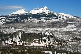
It sits on the border between Linn and Jefferson counties. You can find it about 18 miles (29 kilometers) northwest of a town called Sisters. The pass is located between two large volcanoes: Three Fingered Jack to the north and Mount Washington to the south.
Near the top of the pass, there are also smaller volcanoes. These include cone-shaped hills called cinder cones and flat-topped volcanoes called tuyas.
U.S. Route 20 is a major road that crosses Santiam Pass. This road connects eastern Oregon with the Santiam River valley on the western side. A lake called Lost Lake is right next to the highway, just west of the pass.
You can reach Santiam Pass from the west using three main roads:
- Oregon Route 22, also known as the North Santiam Highway, starts in Salem. It follows the North Santiam River southeast to a place called Santiam Junction.
- U.S. Route 20 follows the South Santiam River. It comes from the Albany and Corvallis area to Santiam Junction.
- Oregon Route 126 follows the McKenzie River. It travels northeast from Eugene.
From the east, you approach Santiam Pass from the town of Sisters. Just east of Sisters, U.S. Highway 20 and Oregon Route 126 split. Oregon Route 126 goes northeast towards Redmond and Prineville, Oregon. U.S. Route 20 heads southeast towards Bend.
History of Santiam Pass
Native American people knew about this pass long ago. The first time it was officially recorded being crossed was in April 1859. This was by a group looking for a way to move cattle over the Cascade Mountains. They wanted to go from the Willamette Valley to Central Oregon.
This group was led by Andrew Wiley. He reportedly climbed a tall tree on a mountain near Lost Prairie to help find the best path. Lost Prairie is located along Hackleman Creek, between Fish Lake and Tombstone Prairie. Andrew Wiley later helped create the Santiam Wagon Road. This was an important road for settlers.
The pass was first called Hogg Pass. It was named after Col. T. Egenton Hogg. He had planned for his railroad to cross here. But in 1929, the Santiam Highway was finished, and the pass was renamed Santiam Pass. The original Santiam Pass, which was discovered in 1859, is actually three miles south of the current one.
Nearby Volcanoes and Mountains
Santiam Pass is surrounded by several interesting volcanoes and mountains. These natural features make the area very beautiful. Some of the notable ones include:
 | Emma Amos |
 | Edward Mitchell Bannister |
 | Larry D. Alexander |
 | Ernie Barnes |

