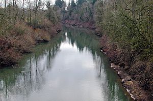
Yamhill River facts for kids
Quick facts for kids Yamhill River |
|
|---|---|

Yamhill River at Dayton
|
|
|
Location of the mouth of the Yamhill River in Oregon
|
|
| Country | United States |
| State | Oregon |
| County | Yamhill |
| Physical characteristics | |
| Main source | confluence of South Yamhill River and North Yamhill River between McMinnville and Dayton, Yamhill County, Oregon 152 ft (46 m) 45°13′33″N 123°08′42″W / 45.22583°N 123.14500°W |
| River mouth | Willamette River Yamhill County, Oregon 59 ft (18 m) 45°13′47″N 122°59′52″W / 45.22972°N 122.99778°W |
| Length | 11 mi (18 km) |
| Basin features | |
| Basin size | 837 sq mi (2,170 km2) |
The Yamhill River is a short river in Oregon, USA. It flows for about 11-mile (18 km) before joining the larger Willamette River. This river is formed when two smaller rivers, the South Yamhill River and the North Yamhill River, meet. This meeting point is about 3 miles (5 km) east of a town called McMinnville.
The Yamhill River helps drain water from a part of the Northern Oregon Coast Range. It winds its way east, passing by Dayton, and then connects with the Willamette River. This happens about 55 miles (89 km) up the Willamette from where it meets the Columbia River, south of Newberg.
The name "Yamhill" likely comes from a Native American tribe. These people lived in the area during the 1800s. The Yamhill people were one of many tribes moved to the Grand Ronde Indian Reservation in 1857.
Contents
Journey of the Yamhill River
The Yamhill River begins when the South Yamhill and North Yamhill rivers combine. This happens about 3 miles (4.8 km) east of McMinnville. From there, the main Yamhill River flows generally east. It travels for about 11 miles (18 km) until it reaches the Willamette River. The Willamette River is a major tributary of the Columbia River.
Where Creeks Join the River
As the Yamhill River flows, several smaller creeks join it. About 9 miles (14 km) from its mouth, Hawn Creek flows into the Yamhill. Soon after, Millican Creek also joins from the river's left side. This is as the Yamhill River gets close to Lafayette, a town located to the river's left.
After passing Lafayette, another creek called Henry Creek adds its water to the Yamhill, also from the left.
Passing Through Dayton
Near the town of Dayton, the river flows under Oregon Route 18. It then goes around the edge of Dayton, which is on the river's right side. This is about 5 miles (8.0 km) from where the Yamhill meets the Willamette. Here, Palmer Creek flows into the Yamhill from the right.
Finally, after Dayton, the Yamhill River flows into the Willamette River. This meeting point is south of Newberg.
Yamhill River Lock and Dam History
A long time ago, in 1900, a special structure was built on the Yamhill River. It was a lock and dam, located about 1.5 miles (2.4 km) downstream from Lafayette.
Why the Dam Was Removed
The lock part of the structure was stopped from being used in 1954. Then, in 1963, the dam itself was taken down on purpose. This was done to help salmon swim more easily up and down the river. Today, the place where the lock and dam once stood is a county park.
 | DeHart Hubbard |
 | Wilma Rudolph |
 | Jesse Owens |
 | Jackie Joyner-Kersee |
 | Major Taylor |


