South Yamhill River facts for kids
Quick facts for kids South Yamhill River |
|
|---|---|

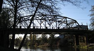
Bridge over the river at Sheridan
|
|
|
Location of the mouth of South Yamhill River in Oregon
|
|
| Country | United States |
| State | Oregon |
| Counties | Polk and Yamhill |
| Physical characteristics | |
| Main source | Northern Oregon Coast Range Siuslaw National Forest, in western Yamhill County, Oregon 551 ft (168 m) 45°06′38″N 123°43′40″W / 45.11056°N 123.72778°W |
| River mouth | Yamhill River between McMinnville and Dayton, Yamhill County, Oregon 75 ft (23 m) 45°13′33″N 123°08′41″W / 45.22583°N 123.14472°W |
| Length | 60 mi (97 km) |
| Basin features | |
| Basin size | 492 sq mi (1,270 km2) |
The South Yamhill River is a river in northwest Oregon, United States. It flows for about 60 miles (97 km) and joins the Yamhill River. This river helps drain water from the Northern Oregon Coast Range and part of the Willamette Valley.
Contents
Where Does the River Start?
The South Yamhill River begins in the Siuslaw National Forest. This area is part of the Northern Oregon Coast Range. The river starts where two smaller streams, Hanchet Creek and Kitten Creek, meet. This spot is about 551 feet (168 meters) above sea level.
The River's Journey Through Oregon
The river flows southeast, mostly staying near Oregon Route 22. It passes through Yamhill County and then enters Polk County. Along its way, many smaller creeks join it.
Passing Through Grand Ronde
The river reaches Grand Ronde Community, which is an Indian reservation. Here, it flows under Grand Ronde Road and Oregon Route 18. Route 18 is a major highway that connects the Portland area to the Oregon Coast.
Flowing Eastward
After Grand Ronde, the river turns east. It runs alongside Route 18, sometimes flowing north of it and sometimes south. It passes through places like Valley Junction and Fort Hill. More creeks, such as Gold Creek and Lady Creek, add to its flow.
Reaching Willamina and Sheridan
The river then reaches Willamina, re-entering Yamhill County. Here, Willamina Creek joins it. As it continues east, it flows between West Valley Highway and Route 18. The river then reaches Sheridan.
Journey to the Yamhill River
After Sheridan, the South Yamhill River turns north. Deer Creek and Salt Creek join it. It flows under Oregon Route 99W and heads toward McMinnville Municipal Airport. The river makes wide turns, eventually flowing past the east side of McMinnville. Here, Cozine Creek joins the river. Finally, the South Yamhill River meets the North Yamhill River. Together, they form the main Yamhill River, which then flows into the Willamette River.
How High Does the River Get?
The water level of the South Yamhill River is measured in two places. Near Willamina, the highest water level ever recorded was about 17 feet (5.2 meters) in December 1964. At McMinnville, the river reached about 59 feet (18 meters) in February 1996. The lowest level recorded at McMinnville was zero in October 1996.
 | James Van Der Zee |
 | Alma Thomas |
 | Ellis Wilson |
 | Margaret Taylor-Burroughs |


