Cleveland S. Rockwell facts for kids
Quick facts for kids
Cleveland S. Rockwell
|
|
|---|---|

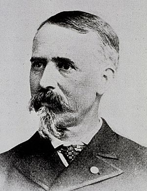
Cleveland Rockwell, 1885
|
|
| Born | November 24, 1837 Youngstown, Ohio, U.S.A. |
| Died | March 22, 1907 (aged 69) Portland, Oregon, U.S.A. |
| Buried |
Portland Memorial Mausoleum
|
| Allegiance | United States of America Union |
| Service/ |
Union Army |
| Years of service | 1863 – 1864 |
| Rank | Captain of Engineers |
| Unit | Army of the Ohio |
| Battles/wars | Sherman's March to the Sea and Carolinas Campaign |
| Other work | Topographical engineer, cartographer, and landscape painter |
Cleveland Salter Rockwell (born November 24, 1837 – died March 22, 1907) was an American engineer, mapmaker, military officer, and artist. He spent most of his career working for the United States Coast and Geodetic Survey. This agency creates maps of coastlines and waterways.
Rockwell mapped many harbors and river systems. He worked on both the Atlantic and Pacific coasts of the United States. He also surveyed areas in South America. During the American Civil War, Rockwell served as a captain in the Union Army. After retiring, he became a successful investor and a well-known landscape painter. Today, his maps are important historical records. His artwork is also famous in the Pacific Northwest.
Contents
What Was Cleveland Rockwell's Early Life Like?
Rockwell was born on November 24, 1837, in Youngstown, Ohio. His parents were Edward and Matilda Rockwell. His father was a successful lawyer and businessman. In 1852, his family moved to Cleveland. His father became the treasurer of a railroad company there.
In 1854, Rockwell went to Troy Academy in Troy, New York. This was a technical school that prepared students for college. He studied mapmaking and related subjects. Later, he transferred to the University of the City of New York. There, he studied mechanical engineering.
In July 1856, Rockwell joined the United States Coastal Survey. This was one of the oldest science groups in the U.S. government. He started as a survey assistant, earning $15 a month plus room and board. His first job was mapping parts of New York Harbor. He also mapped several islands in the East River.
During this survey, Rockwell's boss left for another job. Rockwell, still very young, was put in charge of the survey team. He also managed their support boat. When winter stopped the outdoor work, Rockwell drew detailed maps of the harbor. He used the information his team had collected. The head of the Coastal Survey, Alexander D. Bache, praised Rockwell's work in a report to Congress in 1857.
In 1858, Rockwell worked on a survey of Charleston Harbor in South Carolina. The next year, he helped map the South Carolina shoreline near the Savannah River. In December 1859, his supervisor suddenly died. In January 1860, Rockwell officially took over the survey project. His team mapped 190 miles of coastline in less than six months. Rockwell was again praised for his excellent work.
In 1861, coastal survey projects in South Carolina and Georgia were stopped. This was due to growing tensions between the southern states and the U.S. government. Rockwell spent that winter finishing his South Carolina maps. After South Carolina attacked Fort Sumter in April 1861, his new maps became very important. The United States Navy used them to plan their blockade of southern ports. His maps of Port Royal Sound helped Captain Samuel Francis Du Pont capture Fort Walker. This led to the U.S. occupation of Port Royal in November 1861.
How Did Cleveland Rockwell Serve in the Military?
During the American Civil War, Rockwell became a Captain in the Union Army. Because of his skills as an engineer and mapmaker, he was highly sought after. He served in many different areas during the war. Soon after the war began, he mapped northern Fairfax County, Virginia. This area was next to the Potomac River. General Winfield Scott asked for this survey. It helped the Union Army choose places for defenses around Washington. The survey was finished in July 1861, just before the First Battle of Bull Run.
Rockwell spent most of 1862 finishing his maps of the South Carolina and Georgia coastlines. These maps were vital for the Union blockade. They helped the Navy find hidden spots used by ships trying to sneak past the blockade. With these new maps, the Union Navy's success rate against these ships greatly improved.
Accurate maps were also very important for the Union Army. In February 1863, Rockwell was assigned to survey the Neuse River in North Carolina. He worked under Major General John G. Foster. Rockwell also scouted inland roads to help with Union war plans. In April, he was scouting roads near New Bern, North Carolina. He was with four companies of New York cavalry. They met a smaller group of Confederate cavalry. Rockwell joined the Union cavalry in chasing them. They captured thirteen Confederate troops. This was dangerous for Rockwell, as he was a civilian. If captured, he could have been tried as a spy.
In June 1863, Confederate General Robert E. Lee led his army into Maryland and Pennsylvania. The Coastal Survey offered to send engineers to help Philadelphia expand its defenses. Major General Napoleon J.T. Dana accepted the offer. Rockwell was one of thirteen engineers sent to map areas around the city. They also helped build emergency forts. After the Battle of Gettysburg, the danger to Philadelphia ended. Rockwell was then sent to map the coast near Winter Harbor, Maine. He finished that survey in October 1863.
In November, Rockwell went to support Major General Benjamin F. Butler. Butler commanded Fortress Monroe near Norfolk, Virginia. At Fortress Monroe, Rockwell surveyed a prisoner camp. He finished this job in less than a month.
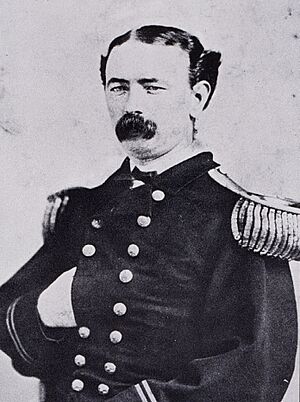
Rockwell's next assignment was in Knoxville, Tennessee. He arrived there on December 12, 1863. The next day, he became a captain in the Union Army's Corps of Topographical Engineers. He was assigned to the Army of the Ohio. This commission protected him from spy charges if he was captured while scouting. It also allowed him to command troops for his survey projects. Rockwell mapped the area around Knoxville, finishing in March 1864. He then mapped specific areas between Knoxville and Jefferson City. He delivered those maps in May.
In the fall of 1864, Rockwell worked on a survey in New York Harbor. Then, in early 1865, Rockwell joined Major General William T. Sherman's army. He was part of Sherman's famous March to the Sea. During this campaign, Rockwell and another officer scouted ahead of the army. They explored roads and sent maps back to commanders. This helped the Army plan their routes. Rockwell also joined General Sherman's march through the Carolinas. In April 1865, Rockwell left the Army and returned to the Coastal Survey.
What Did Rockwell Do in South America?
In August 1865, the President of Colombia asked the United States for help. He wanted coastal engineers to find a way to connect Lake Santa Marta with the Magdalena River. Secretary of State William H. Seward agreed. He asked the Coastal Survey to choose engineers for this job. Rockwell was one of six engineers chosen. He left for Colombia on December 11, 1865.
The survey took about six months. There were delays because Colombian officials tried to reduce the team's pay. They also tried to get the engineers to work on other projects. Rockwell and his team finished their work and returned to New York in June 1866.
What Was Rockwell's Work on the Pacific Coast?
The Coastal Survey moved Rockwell to the west coast in 1868. His first job was to map part of the San Francisco Peninsula in California. This survey was needed to help the Army place new defenses around San Francisco. In July 1868, Rockwell and his assistant went to Oregon. Their task was to map the mouth of the Columbia River. The Columbia was a very important waterway. It had not been mapped since 1852.
Rockwell's measurements showed the river had changed a lot. He also found a new, deeper channel north of Astoria, Oregon. Because of Rockwell's survey, most of the buoys around the Columbia River Bar were moved. This made it safer for ships to enter and leave the river.
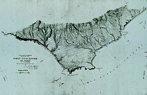
In the winter of 1868 and spring of 1869, Rockwell mapped Point Conception near Santa Barbara, California. In July 1869, he returned to Oregon. He continued his work on the Columbia River. He mapped Cape Disappointment. He also surveyed several bays near the Columbia's mouth. However, his work was made harder by smoke from forest fires, coastal fog, and heavy rains.
In the winter of 1871, Rockwell went back to California to survey San Simeon Bay. When the weather improved in the Pacific Northwest, he moved north. He mapped Puget Sound in Washington state. For the next four years, he kept moving between California and the Pacific Northwest. He worked in the south during winter and spring. Then he moved north from May or June through the fall.
In 1873, Rockwell married Cornelia Fleming Russell. Her uncle was the Governor of Tennessee. Cornelia's family was not happy about the marriage. This was because Rockwell had served in the Union Army during the Civil War. So, the couple married secretly on a ferry boat in San Francisco Bay. After their marriage, Cornelia traveled with Rockwell. She stayed as close as possible to his outdoor work sites. She may have even joined him in some of his field camps. Rockwell spent the next few years in northern California. He worked on surveys of the Russian River and Cape Mendocino. He also pinpointed the locations of many mountain peaks in northern California.
In 1879, Rockwell moved his family home from San Francisco to Portland, Oregon. He spent the next ten years working in the Pacific Northwest. He made regular trips to San Francisco, where the Coastal Survey's west coast office was. During this time, he mapped much of the lower Columbia River. He also mapped the highlands on both sides of the river. Between 1879 and 1884, he mapped the channels of the Columbia's main rivers. This included the Willamette River. His survey of the Willamette River was very detailed. It included 17,782 measurements of water depth. He also mapped 50 miles of Oregon coastline south of Astoria. This included important features like Nestucca Bay and Tillamook Bay. In April and May 1884, Rockwell visited British Columbia and Alaska. He filled his sketchbooks with drawings from his travels.
In the spring of 1890, Rockwell went back to California. He was to help with a big survey of the Los Angeles area. But soon after arriving, he was sent back to San Francisco. He had to take over a survey team whose leader had suddenly died. After finishing a survey of Point Sur in the Big Sur area, he returned to Portland in May 1890. He continued his Columbia River work. On June 1, 1892, Rockwell retired from the Coastal Survey. He had served for thirty-five years.
What Did Cleveland Rockwell Do After Retirement?
By 1892, Rockwell was well known in Portland. His work on the Columbia and Willamette rivers had made shipping safer for the city. His artwork was also greatly admired. Friends who received his paintings or drawings as gifts felt very lucky. After retiring, Rockwell opened an office in downtown Portland. He worked as a consulting engineer.
His father had left him a lot of money, which Rockwell invested. He was on the board of directors for three Portland banks. One of these was the Portland Trust Company. Through his investments, Rockwell became quite wealthy. His financial success allowed him to travel, hunt, and fish whenever he wanted.
Long before he retired, Rockwell had started writing about Oregon. He especially wrote about the Columbia River. His articles were published in magazines like The Pacific Monthly and Harper's Magazine. His articles were always carefully written and accurate. Rockwell usually included many drawings with his articles. This made them much more interesting to read.
Rockwell was a talented artist. He was skilled at drawing, watercolors, and oil painting. In 1873, he showed two of his paintings at the San Francisco Art Association show. He showed two more in their 1874 show. In 1877, Rockwell exhibited four paintings in the San Francisco show. After retirement, Rockwell spent more time painting. In 1883, he began showing his work at the annual Portland Mechanics Fair. He also showed his art at other local exhibitions.
He helped start the Portland Art Club in 1885. He also helped create the Portland Art Association in 1892. In the late 1890s, Rockwell started selling small watercolors for $10 and $20. He also finished several large oil paintings during this time. These were very popular in Portland society. Rockwell died of pneumonia in Portland on March 22, 1907, at age 69. His body was cremated and buried at Portland Memorial Mausoleum.
What Is Cleveland Rockwell's Legacy?
Rockwell played an important role in the early history of California and the Pacific Northwest. His survey teams mapped many major features along the Pacific coast. After Rockwell's death, his wife gave 36 volumes of his survey reports to the Oregon State Library. These reports cover the Columbia River and other areas in Oregon and Washington. Some of his hand-drawn maps are still kept in the archives of the National Oceanic and Atmospheric Administration in Washington, D.C.
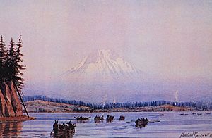
Today, Rockwell's artwork is well known in the Pacific Northwest. Many of his landscape watercolors and oil paintings are based on sketches he made during his survey trips. His paintings were done in the English romantic style. However, his works always showed the real landscapes accurately. It is thought that Rockwell created about 500 finished artworks. Only 134 of his paintings are known today. His sketchbooks also contain several hundred more drawings. Except for three casual portraits, all his known works are landscapes. His paintings and drawings are on display in at least seven west coast museums:
- Anchorage Museum of History and Art in Anchorage, Alaska
- Columbia River Maritime Museum in Astoria, Oregon
- Frye Art Museum in Seattle, Washington
- Glenbow Museum in Calgary, Canada
- Oakland Museum of California in Oakland, California
- Oregon Historical Society in Portland, Oregon
- Seattle Art Museum in Seattle, Washington
Rockwell's paintings and drawings are also sold at national auctions and by art galleries when they become available.
 | George Robert Carruthers |
 | Patricia Bath |
 | Jan Ernst Matzeliger |
 | Alexander Miles |


