Ross Island (Oregon) facts for kids

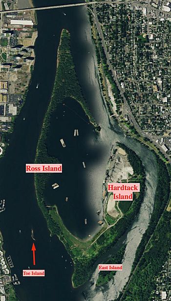
Satellite image of Ross Island, with each of the four islands labeled.
|
|
| Geography | |
|---|---|
| Location | Willamette River RM 14.1–15.7 in Portland, Oregon |
| Coordinates | 45°29′24″N 122°40′01″W / 45.490°N 122.667°W |
| Total islands | 4 |
| Major islands | 2 |
| Area | 0.625 sq mi (1.62 km2) |
| Length | 1.40 mi (2.25 km) |
| Width | 0.37 mi (0.6 km) |
| Highest elevation | 20 ft (6 m) |
| Administration | |
|
United States
|
|
| Demographics | |
| Population | 0 (2008) |
| Pop. density | 0 /sq mi (0 /km2) |
| Additional information | |
| approximately two-thirds of the island has been excavated | |

Ross Island is the main island in a group of four islands. It's located in the Willamette River in Portland, Oregon, in the United States. The islands cover about 400 acres in total.
For many years, from 1926 to 2001, a company called Ross Island Sand and Gravel (RISG) dug up sand and gravel from the islands. The other three islands in the group are Hardtack, East, and Toe Island. Ross Island was named after an early Oregon pioneer named Sherry Ross.
Where is Ross Island?
The islands divide the Willamette River, creating a smaller channel called Holgate Slough on the east side. They are about 1 mile (1.6 km) south of downtown Portland.
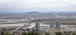
You can find the islands just south of the Ross Island Bridge. They are located between the Springwater Corridor Trail on the east and the South Waterfront on the west. They are also just north of the Oaks Bottom Wildlife Refuge and Willamette Park.
Ross is the longest island and the closest to the western shore. It is also the closest to the Ross Island Bridge. Hardtack Island is to its east. East Island is southeast of Hardtack, and Toe Island is southwest of Ross. There are no bridges to the islands, so you can only reach them by boat.
How the Islands Changed
Ross Island is connected to Hardtack Island by a special wall called a levee. This levee was built in 1926 by the U.S. Army Corps of Engineers. It helped create a calm water area, or lagoon, between the two islands.
This lagoon made it easier for RISG to dredge (dig up material from the riverbed). It also helped move water to the west side of the islands, making the shipping channel deeper for boats.
Protecting Nature
In 2007, the owner of RISG, Robert B. Pamplin, Jr., gave 45 acres (18 ha) of Ross Island to the city of Portland. The city plans to protect this land as a natural area.
The islands still have parts with forests along the riverbanks, called riparian zones. These areas are home to at least 50 different kinds of birds, including ospreys, eagles, and herons.
The city accepted the land after a long discussion. There were some worries about cleaning up the islands. The lagoon between Ross and Hardtack islands has some old, unwanted fill dirt that needs to be cleaned. The Oregon Department of Environmental Quality has listed it for cleanup. However, experts checked the 45 acres given to the city in 2007 and said they were in good condition.
Besides the 45 acres given to the city and the 350 acres (140 ha) still owned by RISG, the Port of Portland owns 10 acres (4.0 ha). People who care about nature hope the Port will also give its land to the city. They also hope that Pamplin and city officials will create a long-term plan to protect all the islands.
 | Emma Amos |
 | Edward Mitchell Bannister |
 | Larry D. Alexander |
 | Ernie Barnes |

