
Independence, Oregon facts for kids
Quick facts for kids
Independence, Oregon
|
|
|---|---|
_(polD0058).jpg)
Independence National Bank
|
|

Location in Oregon
|
|

Independence, Oregon
Location in the United States
|
|
| Country | United States |
| State | Oregon |
| County | Polk |
| Incorporated | 1874 |
| Area | |
| • Total | 3.08 sq mi (7.99 km2) |
| • Land | 2.98 sq mi (7.72 km2) |
| • Water | 0.10 sq mi (0.26 km2) |
| Elevation | 171 ft (52 m) |
| Population
(2020)
|
|
| • Total | 9,828 |
| • Density | 3,295.77/sq mi (1,272.41/km2) |
| Time zone | UTC-8 (Pacific) |
| • Summer (DST) | UTC-7 (Pacific) |
| ZIP code |
97351
|
| Area code(s) | 503 and 971 |
| FIPS code | 41-36150 |
| GNIS feature ID | 2410099 |
| Website | www.ci.independence.or.us |
Independence is a city in Polk County, Oregon, in the United States. It is located on the west bank of the Willamette River. You can find it along Oregon Route 51, just east of Monmouth. Independence is part of the larger Salem Metropolitan Statistical Area.
The oldest part of Independence, covering thirty city blocks, is listed on the National Register of Historic Places. This area is known as the Independence Historic District. In 2020, about 9,828 people lived in Independence.
Contents
History of Independence
How Independence Got Its Name
Independence was founded by early settlers, also called pioneers. They came from a town named Independence, Missouri.
One of the first pioneers was Elvin A. Thorp. He arrived in the area in 1845. He claimed land north of Ash Creek. Thorp then planned out a small town. This town was first called "Thorp's Town of Independence." It is now known as "Old Town." Thorp named the town after his hometown in Missouri. He also wanted to honor the idea of "Independence."
Growth and Development of the City
In 1847, another important person named Henry Hill came to the area. He was looking for flat land to raise farm animals. He found his spot on the west bank of the Willamette River. Hill claimed a large piece of land, about one square mile.
Later, in 1867, after working in the California gold mines, Hill planned out 40 acres for a new town area. This part became known as Henry Hill's Town of Independence. Both Thorp's and Hill's towns officially became one city in 1885. Henry Hill Elementary School was named after Henry Hill.
Independence as a Shipping Center
For many years, Independence was a busy place for shipping goods. Farmers and lumber companies used both trains and boats on the Willamette River. This lasted until the 1950s.
The city was especially famous for growing hops. Hops are used to make beer. This was a big business from the 1890s to the 1940s. Independence even had a "Hops Fiesta" festival every year.
Changes in the Mid-1900s
In the early 1950s, hop farming started to decline. This meant the city became less busy and prosperous. Major highways were built in the 1960s, but they went around downtown Independence. This made the city less of a travel hub. However, a new way to travel arrived when the Independence State Airport opened on August 14, 1964.
Geography of Independence
Independence is located at 44°51′11″N 123°11′29″W / 44.85306°N 123.19139°W. The United States Census Bureau says the city covers about 2.82 square miles (7.30 square kilometers). Most of this area is land (2.73 square miles or 7.07 square kilometers). A small part is water (0.09 square miles or 0.23 square kilometers). Ash Creek flows through Independence and then joins the Willamette River.
Population Facts
| Historical population | |||
|---|---|---|---|
| Census | Pop. | %± | |
| 1860 | 425 | — | |
| 1880 | 691 | — | |
| 1900 | 909 | — | |
| 1910 | 1,160 | 27.6% | |
| 1920 | 1,148 | −1.0% | |
| 1930 | 1,248 | 8.7% | |
| 1940 | 1,372 | 9.9% | |
| 1950 | 1,987 | 44.8% | |
| 1960 | 1,930 | −2.9% | |
| 1970 | 2,594 | 34.4% | |
| 1980 | 4,024 | 55.1% | |
| 1990 | 4,425 | 10.0% | |
| 2000 | 6,035 | 36.4% | |
| 2010 | 8,590 | 42.3% | |
| 2020 | 9,828 | 14.4% | |
| U.S. Decennial Census | |||
Population in 2010
In 2010, there were 8,590 people living in Independence. These people lived in 2,857 households. About 2,021 of these were families. The city had about 3,146 people per square mile.
The people living in Independence came from many different backgrounds.
- About 73.3% were White.
- About 19.1% were from other races.
- About 35.3% of the population identified as Hispanic or Latino.
Many households (42.0%) had children under 18 living there. The average household had almost 3 people. The average family had about 3.45 people.
The average age of people in the city was 28.3 years old.
- About 30.5% of residents were under 18.
- About 13.9% were between 18 and 24.
- About 27.3% were between 25 and 44.
- About 19.5% were between 45 and 64.
- About 8.7% were 65 or older.
The city had slightly more males (50.4%) than females (49.6%).
Education in Independence
Independence shares a school district with Monmouth. This is called the Central School District. Students in both cities attend the same schools. These include:
- Independence Elementary School
- Talmadge Middle School
- Central High School
Images for kids
-
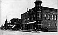
Downtown Independence around 1920, showing the Independence National Bank on the left.

See also
 In Spanish: Independence (Oregón) para niños
