Arco, Idaho facts for kids
Quick facts for kids
Arco, Idaho
|
|
|---|---|
 |
|
| Nickname(s):
Atomic City
|
|

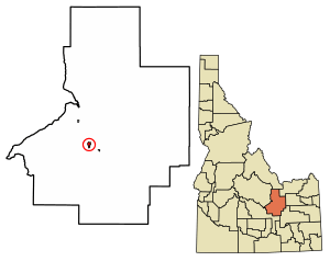
Location of Arco in Butte County, Idaho.
|
|
| Country | United States |
| State | Idaho |
| County | Butte |
| Area | |
| • Total | 1.08 sq mi (2.80 km2) |
| • Land | 1.07 sq mi (2.77 km2) |
| • Water | 0.01 sq mi (0.03 km2) |
| Elevation | 5,309 ft (1,618 m) |
| Population
(2020)
|
|
| • Total | 879 |
| • Density | 814/sq mi (313.9/km2) |
| Time zone | UTC-7 (Mountain (MST)) |
| • Summer (DST) | UTC-6 (MDT) |
| ZIP code |
83213
|
| Area codes | 208, 986 |
| FIPS code | 16-03160 |
| GNIS feature ID | 2409725 |
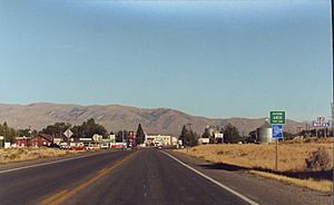
Arco is a city in Butte County, Idaho, United States. It's often called the "Atomic City" because of its special history with nuclear power. In 2020, about 879 people lived there. Arco is the main city and the county seat of Butte County.
Contents
History
Arco got its name around 1860 from a local rancher named Louis Arco. He even set up a ranch and trading post there around 1862.
Arco made history on July 17, 1955! It was the very first town in the world to be lit up by electricity that came only from nuclear power. This amazing event lasted for about an hour. It was powered by a special reactor called BORAX-III. This reactor was located nearby at what is now the Idaho National Laboratory.
Later, on January 3, 1961, another reactor at the same site, called SL-1, had an accident. Sadly, three people were hurt during this event. It was the first time a reactor accident caused harm to people in the United States.
Economy
The main ways people in Arco make a living are connected to the Idaho National Laboratory. This is a large research center. Farming and outdoor activities in the Lost River Valley also help the town's economy.
Highways
Arco is connected by several important highways:
 US 20 — This road goes west to Mountain Home and east to Idaho Falls.
 US 26 — This road goes west to Shoshone and east to Blackfoot.
 US 93 — This road goes north to Challis and south to Twin Falls.
Geography
Arco is located along the Big Lost River. It's a gateway to the Lost River Range mountains from the Snake River Plain. A cool place called Craters of the Moon National Monument is southwest of the city. The Idaho National Laboratory (INL) is located east of Arco.
Just two miles north of Arco is Arco Peak. This mountain rises about 2,220 feet above the city.
The city covers about 1.07 square miles of land. Most of it is land, with a tiny bit of water.
One of the most unique things in Arco is "Number Hill." This is a rocky hill with numbers painted all over it! Since 1920, each graduating class from Butte County High School paints their graduation year on the side of this hill.
Climate
Arco has a climate with warm summers and cold winters. Here's a look at the weather:
| Climate data for Arco, Idaho, 1991–2020 normals, extremes 1914–present | |||||||||||||
|---|---|---|---|---|---|---|---|---|---|---|---|---|---|
| Month | Jan | Feb | Mar | Apr | May | Jun | Jul | Aug | Sep | Oct | Nov | Dec | Year |
| Record high °F (°C) | 52 (11) |
59 (15) |
71 (22) |
87 (31) |
95 (35) |
97 (36) |
102 (39) |
100 (38) |
100 (38) |
85 (29) |
70 (21) |
59 (15) |
102 (39) |
| Mean maximum °F (°C) | 41.9 (5.5) |
45.4 (7.4) |
59.8 (15.4) |
71.6 (22.0) |
81.4 (27.4) |
89.0 (31.7) |
94.9 (34.9) |
93.1 (33.9) |
87.2 (30.7) |
75.4 (24.1) |
58.0 (14.4) |
45.2 (7.3) |
95.8 (35.4) |
| Mean daily maximum °F (°C) | 30.3 (−0.9) |
34.7 (1.5) |
45.9 (7.7) |
57.2 (14.0) |
67.0 (19.4) |
76.4 (24.7) |
86.6 (30.3) |
84.8 (29.3) |
74.9 (23.8) |
59.5 (15.3) |
42.6 (5.9) |
31.2 (−0.4) |
57.6 (14.2) |
| Daily mean °F (°C) | 18.6 (−7.4) |
23.2 (−4.9) |
34.4 (1.3) |
43.8 (6.6) |
52.8 (11.6) |
61.0 (16.1) |
69.1 (20.6) |
67.2 (19.6) |
57.9 (14.4) |
45.0 (7.2) |
30.8 (−0.7) |
20.3 (−6.5) |
43.7 (6.5) |
| Mean daily minimum °F (°C) | 7.0 (−13.9) |
11.7 (−11.3) |
22.8 (−5.1) |
30.4 (−0.9) |
38.6 (3.7) |
45.7 (7.6) |
51.6 (10.9) |
49.5 (9.7) |
41.0 (5.0) |
30.5 (−0.8) |
19.1 (−7.2) |
9.3 (−12.6) |
29.8 (−1.2) |
| Mean minimum °F (°C) | −12.0 (−24.4) |
−7.3 (−21.8) |
6.3 (−14.3) |
18.2 (−7.7) |
25.5 (−3.6) |
33.4 (0.8) |
42.3 (5.7) |
39.1 (3.9) |
28.4 (−2.0) |
16.1 (−8.8) |
2.8 (−16.2) |
−8.7 (−22.6) |
−15.8 (−26.6) |
| Record low °F (°C) | −46 (−43) |
−32 (−36) |
−20 (−29) |
−3 (−19) |
11 (−12) |
20 (−7) |
29 (−2) |
25 (−4) |
11 (−12) |
1 (−17) |
−22 (−30) |
−45 (−43) |
−46 (−43) |
| Average precipitation inches (mm) | 0.67 (17) |
0.62 (16) |
0.68 (17) |
0.86 (22) |
1.20 (30) |
1.13 (29) |
0.32 (8.1) |
0.54 (14) |
0.66 (17) |
0.71 (18) |
0.55 (14) |
0.86 (22) |
8.80 (224) |
| Average snowfall inches (cm) | 7.0 (18) |
4.6 (12) |
1.1 (2.8) |
1.3 (3.3) |
0.2 (0.51) |
0.0 (0.0) |
0.0 (0.0) |
0.0 (0.0) |
0.0 (0.0) |
0.3 (0.76) |
1.2 (3.0) |
8.1 (21) |
23.8 (61.37) |
| Average precipitation days (≥ 0.01 in) | 4.4 | 3.7 | 3.9 | 4.8 | 6.0 | 3.9 | 2.2 | 3.0 | 3.6 | 3.7 | 3.4 | 5.1 | 47.7 |
| Average snowy days (≥ 0.1 in) | 2.7 | 1.5 | 0.8 | 0.6 | 0.2 | 0.0 | 0.0 | 0.0 | 0.0 | 0.0 | 0.9 | 2.5 | 9.2 |
| Source 1: NOAA | |||||||||||||
| Source 2: National Weather Service | |||||||||||||
Demographics
Here's how Arco's population has changed over the years:
| Historical population | |||
|---|---|---|---|
| Census | Pop. | %± | |
| 1910 | 322 | — | |
| 1920 | 737 | 128.9% | |
| 1930 | 572 | −22.4% | |
| 1940 | 548 | −4.2% | |
| 1950 | 961 | 75.4% | |
| 1960 | 1,562 | 62.5% | |
| 1970 | 1,244 | −20.4% | |
| 1980 | 1,241 | −0.2% | |
| 1990 | 1,016 | −18.1% | |
| 2000 | 1,026 | 1.0% | |
| 2010 | 995 | −3.0% | |
| 2020 | 879 | −11.7% | |
| U.S. Decennial Census | |||
2010 Census
In 2010, Arco had 995 people living in 417 households. Most residents (95.1%) were White. About 3% of the population was Hispanic or Latino.
Around 30% of households had children under 18. Almost half (44.4%) were married couples. The average household had 2.35 people. The average age in the city was 41.2 years old.
Notable residents
- C. A. Bottolfsen — He was the Governor of Idaho twice.
- Warren Jones — He became a justice on the Idaho Supreme Court. He was the top student (valedictorian) at Butte County High School in 1961.
See Also
 In Spanish: Arco (Idaho) para niños
 | Anna J. Cooper |
 | Mary McLeod Bethune |
 | Lillie Mae Bradford |


