Butte County, Idaho facts for kids
Quick facts for kids
Butte County
|
||
|---|---|---|

|
||
|
||

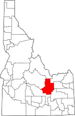
Location within the U.S. state of Idaho
|
||
 Idaho's location within the U.S. |
||
| Country | ||
| State | ||
| Founded | February 6, 1917 | |
| Named for | Big Southern Butte | |
| Seat | Arco | |
| Largest city | Arco | |
| Area | ||
| • Total | 2,234 sq mi (5,790 km2) | |
| • Land | 2,232 sq mi (5,780 km2) | |
| • Water | 2.0 sq mi (5 km2) 0.1% | |
| Population
(2020)
|
||
| • Total | 2,574 |
|
| • Density | 1.3/sq mi (0.5/km2) | |
| Time zone | UTC−7 (Mountain) | |
| • Summer (DST) | UTC−6 (MDT) | |
| Congressional district | 2nd | |
Butte County is a rural county located in the state of Idaho. It's in the western part of the United States. As of the 2020 census, about 2,574 people lived here. This makes it the third-least populated county in Idaho.
The main town and biggest city in Butte County is Arco. The county was created in 1917. It was formed from parts of Bingham, Blaine, and Jefferson counties. In 1937, it gained more land from Custer County. This gave Butte County its current shape.
Contents
History of Butte County
The first settlement in Butte County started around 1878. It was about 4 miles south of where the town of Arco is today. This early settlement was known by names like Kennedy Crossing. It was also called Lower Crossing of the Lost River.
In 1879, a post office was set up there. That's when the settlement officially became known as Arco. Other early towns like Era, Antelope, Martin, and Island (now Moore) were settled before 1890. By 1890, these five settlements had a total of 389 people.
In 1895, these areas became part of Blaine County. By 1900, the population of these areas grew to 714 residents. It increased even more to 1,787 people by 1910. A railroad was built from Blackfoot to Mackay. Because of this, the town of Arco moved to its current location in 1901.
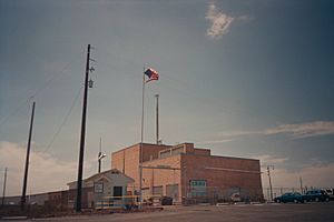
Butte County is part of the Idaho Falls area. A large part of the eastern county is home to the Idaho National Laboratory. This is a big research center that also stretches into nearby counties.
Geography of Butte County

Butte County covers a total area of about 2,234 square miles. Most of this area, about 2,232 square miles, is land. Only a small part, about 2.0 square miles, is water.
The Little Lost River flows through Butte County. Its waters, along with the Big Lost River, seem to disappear from the surface. They actually flow underground into the Snake River Plain aquifer. This happens right here in Butte County.
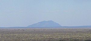
The county gets its name from the volcanic buttes that rise from the flat desert. A "butte" is a tall, isolated hill with steep sides and a flat top. The biggest one is Big Southern Butte. It's located in the southern part of the county. This butte rises about 2,500 feet above the desert floor. Early pioneers used it as an important landmark to guide their journeys.
Part of the Craters of the Moon National Monument and Preserve is in the southwestern part of the county. This unique area extends into three other counties as well. It's a great place to see volcanic landscapes.
Neighboring Counties
Butte County shares its borders with several other counties:
- Custer County - to the northwest
- Lemhi County - to the northwest
- Clark County - to the northeast
- Jefferson County - to the east
- Bingham County - to the southeast
- Blaine County - to the southwest
Major Roads
These are some of the main highways that go through Butte County:
Protected Natural Areas
Parts of these national protected areas are found in Butte County:
- Caribou-Targhee National Forest
- Craters of the Moon National Monument and Preserve
- Salmon-Challis National Forest
Population of Butte County
| Historical population | |||
|---|---|---|---|
| Census | Pop. | %± | |
| 1920 | 2,940 | — | |
| 1930 | 1,934 | −34.2% | |
| 1940 | 1,877 | −2.9% | |
| 1950 | 2,722 | 45.0% | |
| 1960 | 3,498 | 28.5% | |
| 1970 | 2,925 | −16.4% | |
| 1980 | 3,342 | 14.3% | |
| 1990 | 2,918 | −12.7% | |
| 2000 | 2,899 | −0.7% | |
| 2010 | 2,891 | −0.3% | |
| 2020 | 2,574 | −11.0% | |
| 2023 (est.) | 2,758 | −4.6% | |
| U.S. Decennial Census 1790–1960, 1900–1990, 1990–2000, 2010–2020 |
|||
As of the 2010 census, there were 2,891 people living in Butte County. The population density was about 1.3 people per square mile. Most of the people living in the county were white (95.5%). About 4.1% of the population was of Hispanic or Latino origin.
The average age of people in Butte County was about 41.7 years old. About 31.5% of households had children under 18 living with them.
Towns and Communities
Cities in Butte County
Other Communities
These are smaller, unincorporated communities in the county:
- Darlington
- Lost River
- Howe
Education in Butte County
Students in Butte County attend schools in these districts:
- Butte County Joint School District 111
- Mackay Joint School District 182
The College of Eastern Idaho serves this county. However, residents of Butte County do not pay taxes to support this college.
See also
 In Spanish: Condado de Butte (Idaho) para niños
 | Valerie Thomas |
 | Frederick McKinley Jones |
 | George Edward Alcorn Jr. |
 | Thomas Mensah |


