Little Lost River facts for kids
Quick facts for kids Little Lost River |
|
|---|---|

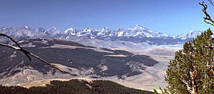
The Little Lost River Valley viewed from the west slope of the Lemhi Range
|
|

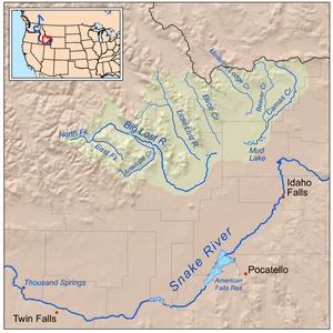
Map of the lost streams of Idaho including the Little Lost River
|
|
| Country | United States |
| State | Idaho |
| City | Howe |
| Physical characteristics | |
| Main source | Confluence of Sawmill and Summit Creeks Upper Little Lost River Valley, Butte County 6,100 ft (1,900 m) 44°11′14″N 113°16′45″W / 44.18722°N 113.27917°W |
| River mouth | Little Lost River Sinks Near Howe, Butte County 4,806 ft (1,465 m) 43°45′52″N 112°58′22″W / 43.76444°N 112.97278°W |
| Length | 49 mi (79 km), Northwest-southeast |
| Basin features | |
| Basin size | 963 sq mi (2,490 km2) |
| Tributaries |
|
The Little Lost River is a cool river found in the middle of Idaho, a state in the United States. It's about 49 miles (79 km) long. This river flows through a dry farming valley called the Little Lost River Valley. Tall mountains, the Lost River Range, are on one side, and the Lemhi Range is on the other.
What makes this river special? Instead of flowing into a bigger river or lake, it just vanishes into the ground! This happens at the edge of the Snake River Plain. That's why it's called the "Lost" River. The water goes deep underground into something called the Snake River Aquifer. Eventually, it reaches the Snake River through many springs further west.
The River's Journey
The Little Lost River starts when two streams, Summit Creek and Sawmill Creek, join together. This spot is about 10 miles (16 km) north of Hawley Mountain. From there, the river flows mostly south-southeast.
Many smaller streams join the Little Lost River along its way. Some of these are Wet Creek (which is the biggest), Badger Creek, Deer Creek, and Uncle Ike Creek. Farmers use the river's water to irrigate their crops.
The only town of any size along the river is Howe. A few miles past Howe, the river disappears into the earth. This happens at about 4,806 feet (1,465 m) above sea level.
The River's Valley
The river drains an area of about 963 square miles (2,490 km2) of land. All of this land is in Butte County. The valley where the river flows is about 50 miles (80 km) long and 20 miles (32 km) wide. The flat part of the valley floor is about 7 miles (11 km) wide.
It doesn't rain much in this area. Most of the water comes from snow that melts in the mountains.
Little Lost River Highway
The Little Lost River Highway is a road that runs north and south in Butte County. It's about 31.2 miles (50.2 km) long. This highway generally follows the lower part of the Little Lost River.
The road starts in the small community of Howe. It connects with SH 33 there. From Howe, the highway goes north-northwest towards another settlement called Clyde. Along the way, the highway crosses the Little Lost River two times. About Three and a half miles (5.6 km) north of Clyde, the highway changes its name to Pahsimeroi Road.
 | Georgia Louise Harris Brown |
 | Julian Abele |
 | Norma Merrick Sklarek |
 | William Sidney Pittman |

