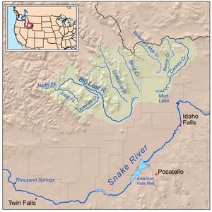
Lost streams of Idaho facts for kids
The Big Lost River and the Little Lost River are two special rivers in Idaho, United States. They are called "Lost" because their water disappears underground! These rivers flow into a low area and then sink into the ground. This water helps fill a huge underground water supply called the Snake River Aquifer.
The rivers are found in Custer County and Butte County. Even though their water goes underground, it eventually comes back up as many springs. These springs then flow into the larger Snake River.
Where the Lost Rivers Flow
The Big Lost River is about 135 miles (217 km) long. It starts high up in the Pioneer Mountains. It flows northeast, then turns southeast. The Lost River Range of mountains separates its valley from the Little Lost River Valley.
Along its path, a dam holds back the Big Lost River, forming a lake called Mackay Reservoir. Near the town of Arco, the river reaches a flat area called the Snake River Plain. Here, it curves east and then northeast. This is where the amazing part happens: the river enters a low area called the Big Lost River Sinks, and its water flows right into the ground! There's even a dry path nearby called the Dry Channel Big Lost River, which only has water sometimes.
The Little Lost River is shorter, about 49 miles (79 km) long. It flows southeast between two mountain ranges: the Lost River Range to its west and the Lemhi Range to its east. This river also reaches the Snake River Plain and flows into its own sinking spots, called the Little Lost River Sinks.
Both rivers' sinking areas are located near the Idaho National Laboratory, which is northeast of Craters of the Moon. The water from these "lost" rivers travels about 100 miles (160 km) underground! It then reappears at places like Thousand Springs near Hagerman and other springs downstream from Twin Falls.
Much of this underground water is used by people for irrigation, which means watering crops. After it's used, some of the water goes back into the ground. Eventually, it makes its way to the springs and joins the Snake River.
River Size and Water Flow
The area that collects water for the Big Lost River is about 1,400 square miles (3,600 km²). The average amount of water flowing in the Big Lost River near Arco is about 91.7 cubic feet per second (2.60 m³/s). Sometimes, it can flow as much as 1,840 cubic feet per second (52 m³/s), and other times, it can have no flow at all!
The Little Lost River collects water from an area of about 971 square miles (2,510 km²). Its average water flow is about 65 cubic feet per second (1.8 m³/s). The most water recorded flowing in it was 486 cubic feet per second (13.8 m³/s), and the least was about 3 cubic feet per second (0.085 m³/s).
 | Jessica Watkins |
 | Robert Henry Lawrence Jr. |
 | Mae Jemison |
 | Sian Proctor |
 | Guion Bluford |


