Hagerman, Idaho facts for kids
Quick facts for kids
Hagerman, Idaho
|
|
|---|---|

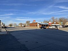
Main street of Hagerman, Idaho. This street runs concurrent with U.S. Highway 30.
|
|

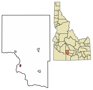
Location of Hagerman in Gooding County, Idaho.
|
|
| Country | United States |
| State | Idaho |
| County | Gooding |
| Area | |
| • Total | 0.61 sq mi (1.58 km2) |
| • Land | 0.59 sq mi (1.52 km2) |
| • Water | 0.02 sq mi (0.06 km2) |
| Elevation | 2,969 ft (905 m) |
| Population
(2010)
|
|
| • Total | 872 |
| • Density | 1,518.71/sq mi (586.24/km2) |
| Time zone | UTC-7 (Mountain (MST)) |
| • Summer (DST) | UTC-6 (MDT) |
| ZIP code |
83332
|
| Area code(s) | 208 |
| FIPS code | 16-34300 |
| GNIS feature ID | 2410680 |
Hagerman is a small city in Gooding County, Idaho, United States. In 2010, about 872 people lived there. The population grew from 656 people in 2000.
The area is famous for its amazing fossil beds. It also has many springs that bubble up from underground. Hagerman is home to a national fish hatchery, which is a place where fish are raised. There is also a university research station and many fish farms. These farms use warm geothermal water to help raise fish.
Contents
Amazing Fossils in Hagerman
Hagerman is home to the Hagerman Fossil Beds National Monument. This is a special park managed by the U.S. National Park Service. It protects some of the best fossil beds from the Pliocene epoch. This time period was about 5.3 to 2.6 million years ago.
No other fossil beds have so many different kinds of land and water animals from this time. Scientists have found over 180 types of animals and 35 types of plants here. These fossils come from hundreds of different sites. Eight of these species are found only in Hagerman. Also, 43 species were first discovered here.
The Hagerman Horse
A great example of the fossils found here is the Hagerman horse. Its scientific name is Equus simplicidens. This horse was an ancient relative of today's horses and looked a bit like a zebra. At the Hagerman Horse Quarry, scientists have found 20 complete skeletons of this horse. They have also found many partial skeletons.
Where is Hagerman?
Hagerman is located in Gooding County, Idaho. The city covers a total area of about 0.60 square miles (1.58 square kilometers). Most of this area, about 0.58 square miles (1.52 square kilometers), is land. A small part, about 0.02 square miles (0.06 square kilometers), is water.
Hagerman's Climate
Hagerman has a cold semi-arid climate. This means it is generally dry, but not a desert. It can get quite cold in winter and very hot in summer. The hottest temperature ever recorded in Hagerman was 112°F (44°C) on July 18, 1998. The coldest temperature recorded was -25°F (-32°C) on December 22, 1990.
People of Hagerman
| Historical population | |||
|---|---|---|---|
| Census | Pop. | %± | |
| 1920 | 327 | — | |
| 1930 | 327 | 0.0% | |
| 1940 | 435 | 33.0% | |
| 1950 | 520 | 19.5% | |
| 1960 | 430 | −17.3% | |
| 1970 | 436 | 1.4% | |
| 1980 | 602 | 38.1% | |
| 1990 | 600 | −0.3% | |
| 2000 | 656 | 9.3% | |
| 2010 | 872 | 32.9% | |
| 2020 | 968 | 11.0% | |
| U.S. Decennial Census | |||
In 2010, there were 872 people living in Hagerman. These people lived in 380 households. About 231 of these households were families. The city had about 1503 people per square mile (586 people per square kilometer).
Most of the people in Hagerman, about 93.8%, were White. About 13.8% of the population was Hispanic or Latino.
Households and Ages
About 26.8% of households had children under 18 living with them. Many households, 45%, were married couples. About 39.2% of households were not families.
The average age of people in Hagerman was 46.1 years old. About 24.4% of residents were under 18. About 25.2% were 65 years or older. The city had slightly more females (51.7%) than males (48.3%).
Education in Hagerman
Students in Hagerman attend schools in the Hagerman Joint School District 233. This district serves the local community.
Gooding County, where Hagerman is located, is also part of the area served by the College of Southern Idaho. This college provides higher education opportunities for students in the region.
See also
 In Spanish: Hagerman (Idaho) para niños
 | Charles R. Drew |
 | Benjamin Banneker |
 | Jane C. Wright |
 | Roger Arliner Young |


