Glacier Peak facts for kids
Quick facts for kids Glacier Peak |
|
|---|---|
| Dakobed Takobia |
|
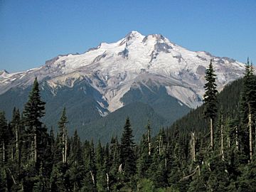
East slope of Glacier Peak with Cool (left), Chocolate (descending from summit), North Guardian and Dusty Glaciers (right)
|
|
| Highest point | |
| Elevation | 10,525+ ft (3,207+ m) NAVD 88 |
| Prominence | 7,498 ft (2,285 m) |
| Listing |
|
| Geography | |
| Location | Snohomish County, Washington, U.S. |
| Parent range | Cascade Range |
| Topo map | USGS Glacier Peak East |
| Geology | |
| Age of rock | Pleistocene |
| Mountain type | Stratovolcano |
| Volcanic arc | Cascade Volcanic Arc |
| Last eruption | 1700 |
| Climbing | |
| First ascent | 1898 by Thomas Gerdine and party |
| Easiest route | Rock/ice climb on Sitkum Glacier |
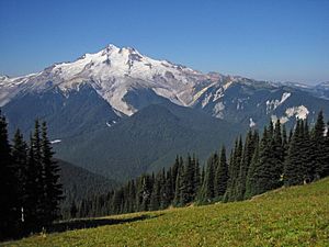
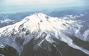
Glacier Peak or Dakobed is a tall mountain in Washington, USA. It is one of the five main stratovolcanoes (cone-shaped volcanoes) in the Cascade Volcanic Arc. This volcano is quite hidden away in the Glacier Peak Wilderness area.
Even though it's far into the mountains, you can sometimes see Glacier Peak from cities like Seattle. It is the fourth tallest peak in Washington state. Local Native Americans have many old stories about Glacier Peak and other volcanoes. Early American explorers didn't know it was a volcano at first. Glacier Peak is about 70 miles (113 km) northeast of Downtown Seattle.
Glacier Peak is one of Washington's most active volcanoes. It started forming about one million years ago during the Pleistocene epoch. After the last ice age, it had some of the biggest and most explosive eruptions in the state. It has erupted strongly five times in the last 3,000 years.
Contents
What is Glacier Peak Made Of?
The top of Glacier Peak is made of old lava domes. These are like hardened piles of thick lava. You can also see signs of past pyroclastic flows (fast-moving hot ash and gas) in nearby river valleys. These flows probably happened when lava domes collapsed.
On the western side of the volcano, there's a large lahar (a mudflow of volcanic ash and water) deposit. This mudflow traveled about 35 km (22 mi) into the White Chuck River Valley around 14,000 years ago. Other mudflows, some as recent as 5,500 years ago, also covered parts of the area.
There are also ash cloud deposits on the eastern side of the volcano. Scientists have found a very thick lahar in Dusty Creek, which is at least 30 meters (98 ft) deep. This area has many layers from past volcanic events. Tephra (pieces of rock and ash thrown out by a volcano) deposits are mostly on the left side of the volcano. Smaller tephra eruptions happened between 6,900–5,500 years ago, 3,450–200 years ago, and even 316–90 years ago.
About 1,800 meters (5,900 ft) up the mountain, there are three small cinder cones. These are small, cone-shaped hills made of volcanic ash and rock. The volcano also has hot springs, which are places where hot water comes out of the ground.
How Volcanoes Form Here
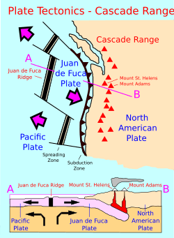
Glacier Peak is in Washington state, part of the Cascade Volcanic Arc. This arc of volcanoes formed because the oceanic Juan de Fuca Plate is slowly sliding under the North American Plate. This movement happens at about 4 cm (1.6 in) per year.
The Cascade Range has been volcanically active for about 36 million years. The volcanoes here don't all erupt at the same time. Scientists group them into "High Cascades" (younger volcanoes) and "Western Cascades" (older volcanoes). However, the volcanoes in Washington are all different ages.
History of Glacier Peak
Long ago, many Native American tribes lived around Glacier Peak. They saw the mountain as a powerful spirit and included it in their stories. When European-American explorers arrived, they heard these legends. But when other volcanoes were mapped, Glacier Peak was often left out.
In 1850, Native Americans told a naturalist named George Gibbs that the volcano had once "smoked." Glacier Peak was finally put on a map in 1898.
Native Americans also used the land around the Cascades for farming. Later, gold miners came to the area between the 1870s and 1890s. The first white person known to see the mountain was Daniel Lindsley in 1870. He was looking for possible railroad routes.
Eruptions of Glacier Peak
Even though Glacier Peak is 10,541 ft (3,213 m) tall, the volcanic part of it is actually quite small. It sits on top of a high ridge. Another volcano like this is the Mount Meager massif in Canada.
Of the five main volcanoes in Washington, only Glacier Peak and Mount St. Helens have had big eruptions in the last 15,000 years. Both volcanoes produce thick, sticky lava called dacite. This thick lava can't flow easily, so it builds up pressure inside the volcano. Eventually, this pressure causes an explosion that shoots out materials like tephra (volcanic ash and rock).
Scientists use methods like radiocarbon dating to figure out when eruptions happened. Glacier Peak had eruptions around 1700 AD, 1300 AD, 900 AD, 200 AD, 850 BC, 3150 BC, and 3550 BC. The size of these eruptions was measured using the Volcanic Explosivity Index (VEI). Most were VEI 2 to 4, which is smaller than the VEI 5 eruption of Mount St. Helens in 1980. These eruptions often started with a central vent eruption, followed by an explosion. They created mudflows, pyroclastic flows, and lava domes.
About 13,000 years ago, there were nine tephra eruptions over a few hundred years. These eruptions also caused pyroclastic flows. When these mixed with snow, ice, and water, they formed huge mudflows (lahars). These lahars rushed into three nearby rivers, filling their valleys with deep deposits. The mudflows reached the Stillaguamish River and Skagit Rivers, all the way to Puget Sound. In Arlington, about 60 miles (97 km) downstream, lahars left seven feet of sediment.
Since then, Glacier Peak has produced several more mudflows. The largest ones happened 5,900 and 1,800 years ago. These mudflows also traveled down the Skagit River to Puget Sound.
What are the Dangers?
The chance of Glacier Peak erupting in any given year is currently about 1 in 1,000.
When lahars (volcanic mudflows) reach towns, they can bury buildings and people. A famous example is the Armero tragedy in Colombia, where 23,000 people died from a huge mudflow. Lahars from Glacier Peak could threaten small towns like Darrington and Concrete. They could also affect larger towns like Mount Vernon and Burlington along the Skagit and Stillaguamish Rivers.
A 2005 study by the United States Geological Survey said that nine Cascade volcanoes, including Glacier Peak, were "very-high-threat volcanoes with inadequate monitoring." At that time, the only device to detect earthquakes on Glacier Peak hadn't worked for two years. Scientists want to watch it more closely.
Glaciers on Glacier Peak
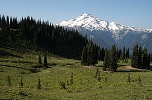
Glacier Peak has eleven important glaciers. When C.E. Rusk first saw them in 1906, they were starting to shrink but were still very large. From the Little Ice Age to 1958, the glaciers on Glacier Peak shrank by about 5,381 ft (1,640 m) on average.
However, in the early 1950s, many glaciers in the North Cascades started to grow again. This happened because of more winter snow and cooler summer temperatures. Ten of the fifteen glaciers around Glacier Peak grew, including all the ones directly on the mountain. These advances ranged from 50 to 1,575 ft (15 to 480 m) and ended in 1978.
From 1984 to 2005, the glaciers started shrinking again. On average, eight Glacier Peak glaciers shrank by about 1,017 ft (310 m) from their largest recent size. Milk Lake Glacier, on the north side of the mountain, completely melted away in the 1990s.
Fun Activities
The Pacific Crest Trail goes close to Glacier Peak. The Suiattle River crossing is a well-known spot on this trail. There used to be a bridge there, but storms washed it away in late 2003.
The first person known to climb Glacier Peak was Thomas Gerdine in 1897. He was with a group of scientists. The volcano is also a great place for skiers. To reach the mountain, you walk about 5 miles (8 km) along the White Chuck River Trail. The slopes are mostly challenging, good for experienced skiers.
See also
 In Spanish: Pico Glacier para niños
 | Audre Lorde |
 | John Berry Meachum |
 | Ferdinand Lee Barnett |


