
Snohomish County, Washington facts for kids
Quick facts for kids
Snohomish County
|
|||
|---|---|---|---|

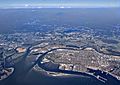
Aerial view of the Snohomish River delta, including portions of Everett, Lake Stevens, and Marysville
|
|||
|
|||

Location within the U.S. state of Washington
|
|||
 Washington's location within the U.S. |
|||
| Country | |||
| State | |||
| Founded | January 14, 1861 | ||
| Named for | the Snohomish people | ||
| Seat | Everett | ||
| Largest city | Everett | ||
| Area | |||
| • Total | 2,196 sq mi (5,690 km2) | ||
| • Land | 2,087 sq mi (5,410 km2) | ||
| • Water | 109 sq mi (280 km2) 5.0% | ||
| Population
(2020)
|
|||
| • Total | 827,957 | ||
| • Estimate
(2023)
|
844,761 |
||
| • Density | 384/sq mi (148/km2) | ||
| Time zone | UTC−8 (Pacific) | ||
| • Summer (DST) | UTC−7 (PDT) | ||
| Area code | 206, 360, 425, 564 | ||
| Congressional districts | 1st, 2nd, 8th | ||

Snohomish County is a county in the state of Washington. It is the third-most populated county in Washington. About 827,957 people lived here in 2020. The main city and county seat is Everett. Snohomish County is part of the larger Seattle metropolitan area.
The western part of the county is near Puget Sound. Most people live in this area. The eastern part has mountains, including the Cascade Range. This area is mostly part of Mount Baker–Snoqualmie National Forest. Snohomish County was created on January 14, 1861. It is named after the Snohomish people. The Tulalip Indian Reservation is also located here.
Since the mid-1900s, Snohomish County has become a center for making airplanes. This is because of the Boeing factory in Everett. Many people also live here and work in nearby Seattle. The county has 18 cities and 2 towns. It is connected by major roads like Interstate 5. A county council and an executive lead the local government.
Contents
What's in a Name? The Story of "Snohomish"
The name "Snohomish" comes from the Native American tribe that lived here. They were the largest group when settlers arrived in the 1800s. In their language, Lushootseed, the name is Sduhubš.
The exact meaning of Sduhubš is not fully clear. Some people thought it meant "lowland people." This would make sense because the tribe lived near the waters of Puget Sound. Others believed it meant "a style of union among them" or "sleeping waters."
The name "Snohomish" is also used for the Snohomish River. This river flows through the county. The City of Snohomish was also named after the tribe. It used to be the county seat. The way we spell "Snohomish" today was decided in 1857.
A Look Back: Snohomish County's History

Long ago, several Coast Salish groups lived in Snohomish County. They mainly settled along the coast and rivers. The Snohomish people were the biggest group. They lived from Warm Beach to Shoreline. The Stillaguamish lived near the Stillaguamish River.
European explorers first mapped this area in the late 1700s. Captain George Vancouver arrived in Puget Sound in 1792. He landed near where Everett is today.
Important Treaties and New Beginnings
The Treaty of Point Elliott was signed in Mukilteo in 1855. This treaty gave away Native American lands in the Puget Sound area. The Tulalip Indian Reservation was created for the tribes. This included the Snohomish, Snoqualmie, and Skykomish people.
Snohomish County was officially created on January 14, 1861. It was formed from parts of Island County and King County. Settlers wanted their own county because it was hard to travel to the old county seat.
Moving the County Seat
At first, Mukilteo was the temporary county seat. Then, after an election, the government moved to Cadyville, which later became Snohomish.
Later, leaders in the new city of Everett wanted the county seat moved there. After a county-wide election in 1894, it was decided to move the county seat to Everett. After some legal arguments, Everett officially became the county seat in December 1896.
Growth and Change Over Time
In the early days, Snohomish County's economy relied on natural resources. These included timber, mining, and farming. Railroads arrived in the late 1800s. This helped new towns grow quickly as people moved in.
During World War II, the county built ships and airplanes for the military. After the war, more people moved to Snohomish County. New neighborhoods were built for people working in Seattle. In 1967, Boeing started building a huge airplane factory in Everett. It is the world's largest building. The U.S. Navy also opened a major base in Everett in 1994.
Where is Snohomish County?

Snohomish County is in the Puget Sound region of Western Washington. To the south is King County. To the west are Puget Sound and other waters. Skagit County is to the north. To the east is Chelan County and the Cascade Range.
The county covers about 2,196 square miles. About 2,087 square miles are land. This makes it the 13th largest county in Washington. It is even bigger than the states of Delaware and Rhode Island.
Land and Mountains
The western part of the county has flat areas and rolling hills. This is where most towns are. The eastern part is mountainous. The Cascade Range runs through it. Much of this area is protected as part of the Mount Baker–Snoqualmie National Forest.
The highest point in Snohomish County is Glacier Peak. It is 10,541 feet above sea level. Several big rivers start in the Cascades. They flow west towards Puget Sound. These include the Stillaguamish and Snohomish rivers. These rivers create valleys that are good for farming. Sometimes, these valleys can flood.
Weather in Snohomish County
The western part of Snohomish County has a mild climate. Summers are dry, and winters are wet. This is typical for the Puget Sound area. The weather is affected by the ocean.
Winter temperatures are usually between 20 and 40 degrees Fahrenheit. Summer temperatures are between 55 and 65 degrees Fahrenheit. In June 2021, the county had record high temperatures, reaching up to 109 degrees Fahrenheit.
The western part of the county gets about 35 inches of rain each year. The mountains get much more, up to 180 inches. Most of the rain falls from October to March. The lowlands usually get 10 to 20 inches of snow each year.
Plants and Animals
About 68 percent of Snohomish County is covered by forests. These are mostly in the eastern parts. The forests have many conifer trees like Douglas firs, hemlocks, and cedars. You can also find some deciduous trees in areas that have been logged.
Who Lives in Snohomish County?
| Historical population | |||
|---|---|---|---|
| Census | Pop. | %± | |
| 1870 | 599 | — | |
| 1880 | 1,387 | 131.6% | |
| 1890 | 8,514 | 513.8% | |
| 1900 | 23,950 | 181.3% | |
| 1910 | 59,209 | 147.2% | |
| 1920 | 67,690 | 14.3% | |
| 1930 | 78,861 | 16.5% | |
| 1940 | 88,754 | 12.5% | |
| 1950 | 111,580 | 25.7% | |
| 1960 | 172,199 | 54.3% | |
| 1970 | 265,236 | 54.0% | |
| 1980 | 337,720 | 27.3% | |
| 1990 | 465,642 | 37.9% | |
| 2000 | 606,024 | 30.1% | |
| 2010 | 713,335 | 17.7% | |
| 2020 | 827,957 | 16.1% | |
| 2023 (est.) | 844,761 | 18.4% | |
| U.S. Decennial Census 1790–1960, 1900–1990, 1990–2000, 2010–2020 |
|||
In 2020, 827,957 people lived in Snohomish County. The population density was about 396.8 people per square mile.
Most people (66.1%) were white. Other groups included Asian (12.3%), Black or African American (3.54%), and Native American (1.3%). About 11.6% of the population was of Hispanic or Latino origin.
In 2010, there were 713,335 people. The average household had 2.62 people. The average family had 3.12 people. The median age was 37.1 years old.
Learning and Education

Snohomish County is one of the largest counties in the U.S. without a four-year university. However, there are many options for higher education.
Columbia College offers associate, bachelor's, and even master's degrees. Everett Community College and Edmonds College offer two-year degrees. They also provide career training and basic education. These two colleges help over 40,000 people each year. About 40% of high school graduates in the county start college at one of these community colleges.
Everett Community College leads the University Center of North Puget Sound. This center offers 25 bachelor's and master's degrees. These degrees come from several universities. These include Western Washington University and the University of Washington Bothell.
Edmonds College and Central Washington University have worked together since 1975. Students can earn a two-year degree from Edmonds College. Then, they can continue their studies for a bachelor's degree from Central Washington University-Lynnwood. This is done in Snoqualmie Hall, a building on the Edmonds College campus.
News and Media
Most people in Snohomish County get their news from Seattle. This includes The Seattle Times newspaper and TV news stations. The Everett Herald is the county's main daily newspaper. There are also weekly newspapers like the Snohomish County Tribune.
The county is part of the Seattle TV market. It gets news from stations like KOMO and KING. Local radio stations include KKXA and KRKO. There are also many smaller online news sites.
Snohomish County has been a filming location for movies and TV shows.
Getting Around: Transportation
Snohomish County has five main roads that connect it to other areas. There are three major roads that go north and south. These are Interstate 5, State Route 9, and State Route 99. The main road that goes east and west is U.S. Route 2.
 Interstate 5
 Interstate 405
 U.S. Route 2
 State Route 9
 State Route 92
 State Route 96
 State Route 99
 State Route 104
 State Route 203
 State Route 204
 State Route 522
 State Route 524
 State Route 525
 State Route 526
 State Route 527
 State Route 528
 State Route 529
 State Route 530
 State Route 531
 State Route 532
Buses and Trains
Several public transportation systems serve Snohomish County. They connect at places like Everett Station and Lynnwood Transit Center. Community Transit runs local buses and commuter buses. These go to the Boeing Everett Factory and Downtown Seattle.
Sound Transit is a regional agency. It offers light rail, commuter rail, and express bus services. These connect to Seattle and Bellevue. Everett Transit serves the city of Everett. Island Transit connects Camano Island to Stanwood and Everett.
The Link light rail system came to Snohomish County in August 2024. It has stations in Mountlake Terrace and Lynnwood. An extension to Everett is planned to open between 2037 and 2041.
Community Transit also has a bus rapid transit network called Swift.
- The Swift Blue Line opened in 2009. It runs from Everett to Shoreline.
- The Swift Green Line goes from the Boeing Everett Factory to Bothell.
- The Swift Orange Line opened in 2024 in Lynnwood and Mill Creek.
- A fourth line, the Swift Gold Line, is planned to connect Everett to Marysville and Smokey Point by 2029.
Sounder commuter trains run between Everett Station and Seattle. They stop in Mukilteo and Edmonds. Amtrak also has train lines that stop in the county. These include the Amtrak Cascades and the Empire Builder.
Airports and Ferries
Snohomish County has one major airport, Paine Field. It has offered passenger flights since March 2019. There are also three smaller public airports for private planes. These are in Arlington, Darrington, and Snohomish.
Two ferry routes connect Snohomish County to other counties. Washington State Ferries operates them.
- The Edmonds–Kingston ferry goes between Edmonds and Kingston in Kitsap County.
- The Mukilteo–Clinton ferry goes from Mukilteo to Clinton on Whidbey Island.
Towns and Cities in Snohomish County
Snohomish County is home to many different communities.
Cities
- Arlington
- Bothell (partly in King County)
- Brier
- Edmonds
- Everett (county seat)
- Gold Bar
- Granite Falls
- Lake Stevens
- Lynnwood
- Marysville
- Mill Creek
- Monroe
- Mountlake Terrace
- Mukilteo
- Snohomish
- Stanwood
- Sultan
- Woodway
Towns
Other Communities
Many other communities are located in Snohomish County. Some are called census-designated places (CDPs). Others are unincorporated communities, meaning they don't have their own local government.
- Alderwood Manor
- Arlington Heights
- Bothell East
- Bothell West
- Bryant
- Bunk Foss
- Canyon Creek
- Cathcart
- Cavalero
- Chain Lake
- Clearview
- Eastmont
- Esperance
- Fobes Hill
- Hat Island
- High Bridge
- Kayak Point
- Lake Bosworth
- Lake Cassidy
- Lake Goodwin
- Lake Ketchum
- Lake Roesiger
- Lake Stickney
- Larch Way
- Lochsloy
- Machias
- Maltby
- Martha Lake
- May Creek
- Meadowdale
- Mill Creek East
- Monroe North
- North Lynnwood
- North Marysville
- North Sultan
- Northwest Stanwood
- Oso
- Perrinville
- Picnic Point
- Silvana
- Silver Firs
- Sisco Heights
- Startup
- Sunday Lake
- Swede Heaven
- Three Lakes
- Verlot
- Warm Beach
- Woods Creek
Unincorporated communities
- Florence
- Fortson
- Galena
- Getchell
- Hazel
- Reiter
- Robe
- Silverton
- Sisco
- Smokey Point
- Trafton
- Tulalip Indian Reservation
Images for kids
-
Aerial view of the Snohomish River delta, including portions of Everett, Lake Stevens, and Marysville
-

Flag of Snohomish County
-

Seal of Snohomish County

See also
 In Spanish: Condado de Snohomish para niños
