Smokey Point, Washington facts for kids
Quick facts for kids
Smokey Point, Washington
|
|
|---|---|

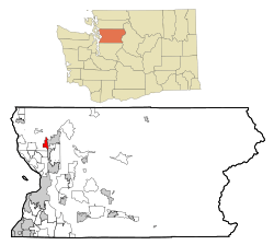
Location of Smokey Point, Washington
|
|
| Country | United States |
| State | Washington |
| County | Snohomish |
| Area | |
| • Total | 2.6 sq mi (6.9 km2) |
| • Land | 2.6 sq mi (6.8 km2) |
| • Water | 0.0 sq mi (0.1 km2) |
| Elevation | 125 ft (38 m) |
| Population
(2000)
|
|
| • Total | 1,556 |
| • Density | 594.0/sq mi (229.3/km2) |
| Time zone | UTC-8 (Pacific (PST)) |
| • Summer (DST) | UTC-7 (PDT) |
| ZIP codes |
98223, 98271
|
| Area code | 360 |
| FIPS code | 53-64995 |
| GNIS feature ID | 1512665 |
Smokey Point is a community in northern Snohomish County, Washington. It used to be a special area called a census-designated place. In the late 1900s and early 2000s, this area grew into a bedroom community where many people live and commute to work. It was then added to the nearby cities of Arlington and Marysville.
Contents
The Story of Smokey Point
Smokey Point started as a small settlement in the early 1900s. It was first known as Rex Corner in the 1930s. This name came from the owner of a restaurant located at what is now Smokey Point Boulevard and 172nd Street NE.
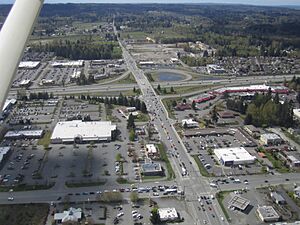
In 1946, Eric and Pearl Shurstad bought the restaurant. They changed it into a barbecue place and called it the "Smokey Point Café." Later, in the late 1960s, the main highway, U.S. Route 99, was replaced by Interstate 5. This new highway created an exit at Smokey Point. It also formed the Gissberg Ponds, which are now called Twin Lakes, from an old gravel pit.
Plans for a College and Growth
In 1966, people thought about building a four-year college in Smokey Point. The city of Arlington even offered 645 acres of land for it. But the state decided to build the college in Olympia instead. That college became The Evergreen State College.
By 1977, more people were moving to the area between Arlington and Marysville, including Smokey Point. The population grew to 16,000 people. In 1979, the Snohomish County Sherriff's Office opened a police station in Smokey Point.
In the early 1990s, Smokey Point was set up to have more factories and businesses. This was to help with a shortage of land for industries in the region. After a new naval base opened in Everett in 1994, the U.S. Navy chose Smokey Point for a support center. This center would have a grocery store for military families, offices, and a college. The 52-acre support center started being built in 1993 and opened in 1995.
In the 1990s, there was a plan to make Arlington Municipal Airport bigger. The idea was to help with busy air traffic at Seattle–Tacoma International Airport. But officials decided to build a third runway at Sea-Tac instead. This was because of existing traffic and people in Smokey Point not wanting the airport to expand.
In 2004, Marysville planned to build a large NASCAR racetrack south of Smokey Point. But this project was canceled two months later. People worried about traffic, the environment, and the high cost of road improvements. Later, the NASCAR site was considered for a new University of Washington campus. This campus, called UW North Sound, was put on hold in 2008 and canceled in 2011.
Annexation Challenges
In the early 1990s, there was a big debate about which city Smokey Point should join. Some property owners wanted to join Arlington, while others wanted to join Marysville. The group wanting to join Arlington reached the needed support first.
Marysville, which provided water and sewer services to the area, challenged this. A group of residents also opposed it. At first, there was one growth boundary for Arlington, Smokey Point, and Marysville. This made things confusing. After many meetings, Snohomish County officials gave Arlington the northeast part of Smokey Point and Marysville the western and southern parts. However, many people in the community did not like this. They wanted their whole community to be part of just one city. The County Council made the final decision and approved the split.
There was also a state law that would have moved the annexed land from the Lakewood School District to the school district of the annexing city. This would have hurt the Lakewood School District because most of the businesses in Smokey Point were joining Arlington. Local residents tried to make Smokey Point its own city to protect the school district's tax money.
Because of these issues, a group called Save Our Community and Schools (SOCS) was formed. SOCS worked hard to change the law to protect the Lakewood School District. They succeeded, and the Lakewood School District is still together today.
SOCS also tried to make Smokey Point and Lakewood into one new city. But this plan was put on hold because state law said a new city could not be formed while an annexation was still pending.
After many years of court cases and disagreements, the annexation issue was finally settled in 1999. The city of Arlington annexed the northeast part of Smokey Point. This was a smaller area than first planned because of the new boundaries. As a result, the dream of keeping Smokey Point as one community or making it its own city ended. Later, the southern and western parts of Smokey Point were annexed into the city of Marysville, as expected.
Business Growth
Smokey Point has seen a lot of business growth. The western side, which is now part of Marysville, has grown a lot. In late 2006, a shopping area called "Lakewood Crossing" opened near the Interstate 5 exit for Smokey Point.
Other areas have also grown. In the late 2010s, a part of Smokey Point Boulevard became an area with many car dealerships. Several car dealerships moved there from Marysville. Many large industrial buildings are also being built in the area, including a big Amazon distribution center.
Geography of Smokey Point
Smokey Point is located at 48°8′45″N 122°11′41″W / 48.14583°N 122.19472°W.
According to the United States Census Bureau, the area used to be about 6.9 square kilometers (2.6 square miles) in total. Most of this area, about 6.8 square kilometers (2.6 square miles), is land. A small part, about 0.1 square kilometers (0.0 square miles), is water.
People in Smokey Point
| Historical population | |||
|---|---|---|---|
| Census | Pop. | %± | |
| 1990 | 2,620 | — | |
| 2000 | 1,556 | −40.6% | |
| source: | |||
In 2000, there were 1,556 people living in Smokey Point. There were 628 households and 425 families. The population density was about 229 people per square kilometer (594 people per square mile).
- About 87% of the people were White.
- About 1.4% were African American.
- About 0.8% were Native American.
- About 4.8% were Asian.
- About 0.3% were Pacific Islander.
- About 1.4% were from other races.
- About 4.2% were from two or more races.
- About 5.8% of the population was Hispanic or Latino.
About 32% of households had children under 18 living with them. About 58% were married couples. The average household had 2.48 people, and the average family had 2.99 people.
The median age in Smokey Point was 37 years old.
- About 25% of the population was under 18.
- About 7% was between 18 and 24.
- About 31% was between 25 and 44.
- About 20% was between 45 and 64.
- About 17% was 65 years or older.
The median income for a household was $46,202. For a family, it was $53,828.
Getting Around Smokey Point
Several important roads go through Smokey Point. These include Interstate 5, Smokey Point Boulevard, State Route 531 (also known as 172nd Street NE), and 51st Avenue NE.
Local Services
The closest hospital is Cascade Valley Hospital and Clinics in Arlington. Smokey Point has its own clinic, the Cascade Skagit Health Alliance clinic. This clinic offers general and specialized medical services. It has about 68 rooms and can help up to 31,000 patients each year.
Sports in the Community
The stadium at Lakewood High School is home to the Snohomish County FC Steelheads. This is a semi-professional soccer team.
See also
 In Spanish: Smokey Point (Washington) para niños
 | Aurelia Browder |
 | Nannie Helen Burroughs |
 | Michelle Alexander |


