Monroe, Washington facts for kids
Quick facts for kids
Monroe
|
|
|---|---|
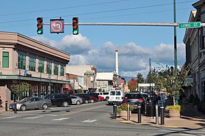
Main Street and Lewis Street in downtown Monroe
|
|
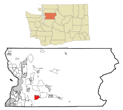
Location of Monroe, Washington
|
|
| Country | United States |
| State | Washington |
| County | Snohomish |
| Founded | 1864 |
| Incorporated | December 20, 1902 |
| Government | |
| • Type | Mayor–council |
| Area | |
| • Total | 6.16 sq mi (15.95 km2) |
| • Land | 6.10 sq mi (15.79 km2) |
| • Water | 0.06 sq mi (0.16 km2) |
| Elevation | 72 ft (22 m) |
| Population
(2020)
|
|
| • Total | 19,699 |
| • Estimate
(2022)
|
19,243 |
| • Density | 3,243.56/sq mi (1,252.39/km2) |
| Time zone | UTC-8 (Pacific (PST)) |
| • Summer (DST) | UTC-7 (PDT) |
| ZIP code |
98272
|
| Area code | 360 |
| FIPS code | 53-46685 |
| GNIS feature ID | 1523319 |
Monroe is a city in Snohomish County, Washington, United States. It sits where the Skykomish, Snohomish, and Snoqualmie rivers meet. This area is close to the Cascade foothills, about 30 miles (48 km) northeast of Seattle. In 2020, about 19,699 people lived in Monroe.
The city started in 1864 as Park Place, a town near the rivers. This spot was once a trading post for the native Skykomish people. Park Place was renamed Monroe in 1890 to honor U.S. President James Monroe. It moved northeast to be closer to the Great Northern Railway tracks, built in 1892. Monroe officially became a city in 1902. It became home to a large condensed milk factory and a state correctional facility.
Later in the 1900s, Monroe grew into a bedroom community, meaning many people who live there travel to work in nearby cities like Everett or Seattle. Today, it has the Monroe Correctional Complex and hosts the Evergreen State Fair every summer. The city is also at the meeting point of two main highways, U.S. Route 2 and State Route 522. These roads were made bigger to help commuters travel more easily.
Contents
Exploring Monroe's Past
Early Days and First Settlers
The area where Monroe is now was originally home to the Skykomish people. They lived near where the Skykomish and Snoqualmie rivers meet. This spot was called Tualco and was an important trading place. Another nearby village was used by the S'dodohobc group of the Snohomish people. The land was cleared to grow berries and hazelnuts. In 1855, the Skykomish and other tribes signed the Treaty of Point Elliott, giving up their traditional lands.
Even before the treaty was fully approved, American settlers started arriving. Robert Smallman, from England, was the first to settle in the Monroe area in 1855. Henry McClurg and his wife Martha arrived in 1860. McClurg later founded Park Place in 1864, about 1 mile (1.6 km) west of today's downtown Monroe. Other settlers, like Salem Woods and Charles Harriman, also came around this time.
Park Place and Tualco grew as more people moved in during the 1860s and 1870s. A local school district was set up in 1869. Park Place got a post office in 1877. A ferry started crossing the Skykomish River in 1882, and later, steamships traveled the river. The first roads were built in 1882, connecting Park Place to Snohomish. In the 1880s, settlers started raising dairy cattle and growing hops. Hops were a good crop for a while, but then a tiny bug and money problems in the 1890s ruined the harvest.
How Monroe Got Its Name
The old Park Place post office closed, and a new one opened in 1890. John Vanasdlen, who ran the new store, wanted to reopen the post office. However, the U.S. Post Office Department only allowed single-word names. Vanasdlen and McClurg chose "Monroe" to honor U.S. President James Monroe. The new Monroe post office opened on March 19, 1890.
The Great Northern Railway decided to build its cross-country railroad through Stevens Pass in the late 1880s. This brought new growth to the Skykomish Valley. Park Place was mapped out in 1890 and gained new businesses like a blacksmith, grocery store, and hotel. But in 1891, the railroad tracks were planned about 1 mile (1.6 km) northeast of Park Place, bypassing the town.
The railroad built a small station called "Wales" on Jack Stretch's land. Stretch created a new settlement called "Tye City" next to the tracks. The railroad was finished in January 1893. In late 1892 and early 1893, many businesses from Park Place moved their buildings to Tye City using teams of animals. After the post office moved, the new settlement became known as Monroe.
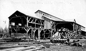
The railroad brought lumber companies to Monroe. The first shingle mill opened in 1894, and a sawmill opened in 1897. A bridge over the Skykomish River opened in 1894, replacing the ferry. The town's first church was built two years later. The county also set up a facility for those in need north of Monroe, where the Evergreen State Fairgrounds are today. Farmers in Monroe built the city's first creamery in 1895, which was later rebuilt after a fire. By 1900, Monroe also had a new school, telephone service, a local newspaper, a doctor, and paved sidewalks.
Becoming a City and New Businesses

On September 16, 1901, a fire destroyed many businesses in Monroe. But the town quickly rebuilt. Monroe officially became a city on December 20, 1902, after a vote. At that time, the area had over 900 residents and many businesses. A new town hall was finished in 1908, which is now a local history museum.
The city government allowed a private company to provide water in 1903. Later, the city built its own water system in 1923. Monroe also got electricity and a hospital in 1903. New roads and bridges were built, connecting Monroe to other towns.
In 1907, the state government chose Monroe for its second reformatory (a type of correctional facility). Construction began in 1910. The Pacific Coast Condensed Milk Company opened a large milk condensery in Monroe on August 29, 1908. This plant was the biggest producer of Carnation brand condensed milk. It helped Monroe's population grow to 2,500 people within two years. The Carnation condensery closed in 1928 and was destroyed by a fire in 1944.
By the early 1910s, Monroe had several school districts. A new high school opened in 1911. The Great Northern Railway built a new train station in 1909. The local timber industry slowed down, and farming became more important, especially dairy, vegetable, and berry farms.
Community Events and Growth
During the 1920s, Monroe's industries grew, bringing new businesses and even an early radio station. The county opened a new hospital in 1925. The town also gained new churches, a movie theater, and a large greenhouse run by the Great Northern Railway.
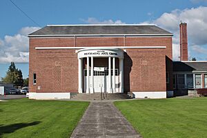
During the Great Depression in the 1930s, many farms struggled. Local groups helped unemployed residents with food and clothing. The Works Progress Administration (WPA) helped Monroe by fixing flood damage and improving roads. They also built a new middle school with an auditorium, which is now the Wagner Performing Arts Center.
Local farming groups started holding agricultural fairs and parades in the 1930s. The first Snohomish County Fair was held at the county farm grounds in 1946. It was renamed the Evergreen State Fair in 1949 and has been held in Monroe every year since. U.S. Route 2, a major highway, opened through the fairgrounds in 1949.
After the Great Depression and World War II, Monroe's economy relied more on farming and smaller businesses. A new hospital, Valley General Hospital, was built in 1961. A big earthquake in 1965 damaged the original Monroe High School. A new high school building opened in 1968. The Great Northern Railway became part of the Burlington Northern Railroad in 1970, and the Monroe train station was taken down.
Modern Suburban Development
State Route 522, a new highway connecting Monroe to Bothell, opened in 1965. This made it easier for people to travel, turning Monroe into a bedroom community for workers in Everett, Seattle, and the Eastside. New neighborhoods were built and added to the city. A new state prison, the Twin Rivers Corrections Center, opened in 1984, bringing new jobs.
In the late 1980s, a large farm area in western Monroe was sold to a developer. This led to the creation of the "Fryelands" neighborhood, with homes and businesses. An artificial lake called Lake Tye was created as part of this project, offering wetlands and a park. Between 1990 and 2000, Monroe's population doubled to over 13,000 people.
More homes meant more traffic on State Route 522. The state began widening the highway in 1995 to make it safer. In the 1990s and 2000s, many large strip malls and big-box stores were built along U.S. Route 2. Groups like the Downtown Revitalization and Enhancement Association of Monroe (DREAM) work to improve downtown Monroe and keep its main street special.
Monroe's Location and Environment
Monroe is in south-central Snohomish County. It's located near where the Skykomish and Snoqualmie rivers meet to form the Snohomish River. The city is in the western foothills of the Cascade Range and is crossed by U.S. Route 2, a major highway.
The city covers about 6.11 square miles (15.83 sq km). Most of this is land, with a small amount of water. The city's edges are generally defined by Lake Tye to the west, the Skykomish River to the south, and Woods Creek to the east. Monroe also has an area outside its main limits that is planned for future growth. The city has grown by adding land to its borders over the years.
Monroe is at the eastern end of the Snohomish River floodplain, with elevations from 40 to 210 feet (12 to 64 m). Areas near the Skykomish River can flood and are home to migratory birds and game animals. The city's neighborhoods are in the watersheds of French Creek and Woods Creek, which flow into the Skykomish River. Monroe is also on a local fault line. In 2019, two small earthquakes happened here, felt in Seattle and Vancouver, but they didn't cause damage.
Monroe's Weather
Monroe has weather similar to most of the Puget Sound area. Summers are dry, and winters are mild and rainy. Most of the rain falls in winter and early spring. Monroe gets rain about 177 days a year. Because it's in the Cascade foothills, Monroe gets more rain than nearby cities, about 48 inches (122 cm) annually. It rarely gets much snowfall, averaging about 8 inches (20 cm) per year since 1929.
July is the warmest month, with average high temperatures around 76.4°F (24.7°C). January is the coolest, with average highs around 44.9°F (7.2°C). The hottest temperature ever recorded was 102°F (39°C) on July 29, 2009. The coldest was -3°F (-19°C) on January 18, 1950. In March 2017, a small EF0 tornado hit Monroe, damaging some vehicles but not hurting anyone. Tornadoes are rare in Western Washington.
| Climate data for Monroe, WA (1991-2020 normals; extremes 1929-present) | |||||||||||||
|---|---|---|---|---|---|---|---|---|---|---|---|---|---|
| Month | Jan | Feb | Mar | Apr | May | Jun | Jul | Aug | Sep | Oct | Nov | Dec | Year |
| Record high °F (°C) | 72 (22) |
75 (24) |
79 (26) |
88 (31) |
94 (34) |
100 (38) |
102 (39) |
101 (38) |
97 (36) |
88 (31) |
77 (25) |
66 (19) |
102 (39) |
| Mean daily maximum °F (°C) | 45.5 (7.5) |
49.1 (9.5) |
53.6 (12.0) |
58.8 (14.9) |
65.5 (18.6) |
69.3 (20.7) |
75.7 (24.3) |
76.2 (24.6) |
70.1 (21.2) |
59.2 (15.1) |
49.7 (9.8) |
44.0 (6.7) |
58.3 (14.6) |
| Daily mean °F (°C) | 39.5 (4.2) |
41.3 (5.2) |
45.0 (7.2) |
49.5 (9.7) |
55.5 (13.1) |
59.7 (15.4) |
64.6 (18.1) |
64.7 (18.2) |
59.7 (15.4) |
51.0 (10.6) |
43.1 (6.2) |
38.4 (3.6) |
51.0 (10.6) |
| Mean daily minimum °F (°C) | 33.5 (0.8) |
33.6 (0.9) |
36.5 (2.5) |
40.1 (4.5) |
45.6 (7.6) |
50.1 (10.1) |
53.5 (11.9) |
53.1 (11.7) |
49.1 (9.5) |
42.9 (6.1) |
36.6 (2.6) |
32.9 (0.5) |
42.3 (5.7) |
| Record low °F (°C) | −3 (−19) |
−2 (−19) |
12 (−11) |
23 (−5) |
29 (−2) |
34 (1) |
33 (1) |
35 (2) |
30 (−1) |
21 (−6) |
1 (−17) |
1 (−17) |
−3 (−19) |
| Average precipitation inches (mm) | 6.15 (156) |
4.49 (114) |
5.22 (133) |
4.38 (111) |
3.28 (83) |
2.53 (64) |
1.15 (29) |
1.23 (31) |
2.76 (70) |
5.03 (128) |
7.39 (188) |
6.88 (175) |
50.49 (1,282) |
| Average snowfall inches (cm) | 0.9 (2.3) |
1.8 (4.6) |
0.2 (0.51) |
0.0 (0.0) |
0.0 (0.0) |
0.0 (0.0) |
0.0 (0.0) |
0.0 (0.0) |
0.0 (0.0) |
0.0 (0.0) |
0.3 (0.76) |
1.4 (3.6) |
4.6 (11.77) |
| Average precipitation days (≥ 0.01 in) | 20.4 | 17.3 | 20.4 | 17.3 | 14.2 | 12.4 | 6.4 | 6.1 | 11.3 | 17.8 | 21.6 | 21.9 | 187.1 |
| Average snowy days (≥ 0.1 in) | 0.4 | 0.6 | 0.2 | 0.0 | 0.0 | 0.0 | 0.0 | 0.0 | 0.0 | 0.0 | 0.2 | 0.6 | 2 |
| Source: NOAA | |||||||||||||
Monroe's Economy and Jobs
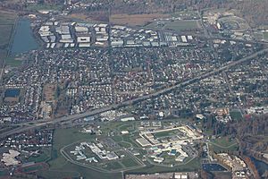
Monroe has about 7,644 working residents. Only 15 percent of them work within the city. Most people travel to other cities like Seattle (15%), Everett (9%), or Redmond (9%) for their jobs. The average trip to work for Monroe residents is about 30.8 minutes. Most people drive alone (75%), while some carpool (14%) or use public transit (3%). Many Monroe residents work in education and health care (19%), manufacturing (15%), or retail (13%).
The city of Monroe itself has 9,466 jobs. The biggest employer is the Washington State Department of Corrections, which runs the Monroe Correctional Complex and provides over 1,100 jobs. Other large employers include the Monroe School District, the Cadman quarry, the Evergreen State Fair, and EvergreenHealth Monroe hospital. The Fryelands area has a large business park with many jobs. Other major job areas include professional services, government, and retail stores along U.S. Route 2.
Monroe's Population and People
| Historical population | |||
|---|---|---|---|
| Census | Pop. | %± | |
| 1910 | 1,552 | — | |
| 1920 | 1,675 | 7.9% | |
| 1930 | 1,570 | −6.3% | |
| 1940 | 1,590 | 1.3% | |
| 1950 | 1,556 | −2.1% | |
| 1960 | 1,901 | 22.2% | |
| 1970 | 2,687 | 41.3% | |
| 1980 | 2,869 | 6.8% | |
| 1990 | 4,278 | 49.1% | |
| 2000 | 13,795 | 222.5% | |
| 2010 | 17,304 | 25.4% | |
| 2020 | 19,699 | 13.8% | |
| 2022 (est.) | 19,243 | 11.2% | |
| U.S. Decennial Census 2020 Census |
|||
Monroe is the ninth largest city in Snohomish County. In 2021, about 20,209 people lived there. The city has a larger Hispanic and Latino population compared to the rest of the county. Monroe's population grew quickly after it became a city in 1902. It stayed under 2,000 until the 1970s. Then, as new roads and neighborhoods were built, the population increased a lot, especially in the 1990s and early 2000s. The number of people living at the Monroe Correctional Complex has been included in the city's population counts since 1996. Most homes in Monroe (over 65%) are single-family houses.
Monroe's Population in 2010
According to the 2010 census, Monroe had 17,304 people living in 5,024 households. The city had about 2,860 people per square mile (1,104 per sq km). Most residents (78.6%) were White. There were also people who identified as African American (3.5%), Native American (1.4%), Asian (2.8%), Pacific Islander (0.4%), and other races. About 17.1% of the population was Hispanic or Latino.
In the households, 46.6% had children under 18. About 54.0% were married couples. The average household had 2.92 people, and the average family had 3.41 people. The average age in Monroe was 33.1 years. About 26.6% of residents were under 18, and 7.2% were 65 or older. The population was 56.3% male and 43.7% female.
Monroe's Culture and Fun
Arts and Entertainment
A non-profit arts council was started in Monroe in 2003. This group helps fund art projects and events in the city. For example, they helped create an 80-foot (24 m) mural showing local river life in downtown Monroe in 2004. The arts council also turned an old elementary school auditorium into the city's performing arts center.
Monroe has been a filming location for several movies and TV shows. Parts of the 1981 film Jacqueline Bouvier Kennedy were filmed here. The Emerald Glen Farm was used for the 1984 TV series Hot Pursuit and horror films like The Ring. Scenes from The Butterfly Effect and Late Autumn were filmed at the Monroe Correctional Complex. The first episode of the web series The Man in the High Castle also has a scene filmed at the Lewis Street Bridge.
Attractions and Events
Monroe is famous for the annual Evergreen State Fair. This big county fair happens in late August and early September at the fairgrounds northwest of downtown. It's the second largest fair in Washington state, attracting about 350,000 visitors over twelve days. The city also has a parade during the fair's opening weekend. The 200-acre (81 ha) fairgrounds, owned by the county, host other events all year. The fairgrounds also have the Evergreen Speedway, a racetrack that once hosted NASCAR races.
The Summer Meltdown music festival moved to Monroe in 2022, drawing about 4,000 people. The annual Washington Midsummer Renaissance Faire also moved to Sky Meadows Park near Monroe in 2023.
The Reptile Zoo, also known as the Washington Serpentarium, is a roadside animal park for reptiles. It's located on U.S. Route 2 east of Monroe. This 3,000-square-foot (280 sq m) building houses 150 creatures and gets 40,000 visitors each year. It moved to the Monroe area in 2003.
Parks and Recreation
Monroe has 14 parks, covering a total of 207 acres (84 ha). The city's parks and recreation department takes care of these parks and organizes fun events for residents. Monroe also has 14 miles (23 km) of trails for walking and biking that connect neighborhoods and parks. The city's biggest park is Al Borlin Park, a 90-acre (36 ha) nature preserve with hiking trails. The city is also near two county parks: Lord Hill Regional Park, a 1,300-acre (530 ha) nature reserve, and Fairfield Park, which has several soccer fields.
The largest community park in Monroe is the 64.5-acre (26.1 ha) Lake Tye Park. It has sports fields, a skate park, and a 49-acre (20 ha) artificial lake where you can fish. In 2014, the city suggested building a 7-mile (11 km) walking and biking trail to Snohomish, which would connect to the regional Centennial Trail.
Local Media and Library
Monroe is served by The Everett Herald and The Seattle Times, which are daily newspapers for the Puget Sound area. The Monroe Monitor and Valley News was a local weekly newspaper published in Monroe since 1899, but it stopped publishing in 2021.
Monroe has a public library run by the Sno-Isle Libraries system. The city's first library opened in 1906. A dedicated library building opened in 1966. The current library building opened in 2002 and cost $6.8 million to build. It's 20,000 square feet (1,900 sq m) and has 84,000 items. The Monroe library serves over 36,622 residents and loaned out over 291,000 items in 2014.
Preserving Monroe's History
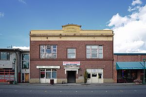
Monroe's local historical society started in 1976. It runs a museum that opened in 1982 in the old city hall building from 1908. The museum has local items, like a carved canoe and old photos. The historical society also has an exhibit at the Evergreen State Fair in the Shannahan Cabin, a historic home from the 1880s. The fairgrounds also have the Western Heritage Center, a museum with old farming and industrial tools.
Downtown Monroe has several historic buildings from the early 1900s that have been preserved. At the northeast end of downtown, there's a 150-foot (46 m) tall steam stack. This is the last part of a Carnation milk condensery plant built in 1908 that burned down in 1944.
Famous People from Monroe
Monroe has been home to several notable people:
- Kathryn Aalto, landscape designer and author
- Benson Boone, singer
- Chuck Close, painter and photographer
- Anthony Curcio, American football player and author
- Ben Dragavon, professional soccer player and coach
- Chad Eaton, American football player
- Blye Pagon Faust, film producer
- Roger Fisher, guitarist
- James Fogle, author
- Little Current, racehorse
- Arthur H. Livermore, science educator and chemist
- Alex Love, flyweight boxer
- Lloyd Meeds, U.S. representative
- Lee Orr, track and field Olympian
- Ian Parmley, professional baseball player
- Kirk Pearson, state representative and senator
- Elizabeth Scott, state representative
- Dave Somers, county executive
- Joseph J. Tyson, Catholic bishop
- Yukon Eric, professional wrestler
Monroe's Schools and Learning
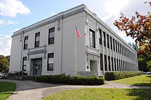
The Monroe School District runs the public schools in the city and nearby areas. In 2016, about 7,096 students were enrolled. The district has one high school, Monroe High School, which opened in 1999.
The district also has one middle school and three elementary schools within Monroe. Many of these schools were updated in 2018. The district's main offices are in the old Central Grade School building, which opened in 1916.
The school district also has special learning centers, like the Sky Valley Educational Center. This center was involved in lawsuits where students, parents, and teachers sued over exposure to harmful chemicals. The lawsuits were settled, with money awarded for the cleanup and damages.
Monroe is also home to the East Campus of Everett Community College. This branch campus opened in 1999 and moved to a new building near Lake Tye in 2010. It has about 400 students.
Monroe's Services and Transport
Getting Around Monroe
Monroe is at the meeting point of three highways:
- U.S. Route 2 (US 2): Goes east from Everett and over Stevens Pass.
- State Route 203: Goes south along the Snoqualmie River.
- State Route 522: An expressway that connects Monroe to Seattle and Bothell.
Other important roads in Monroe include Main Street and North Kelsey Street. US 2 often has traffic jams in Monroe, and there have been plans for a bypass road, but it's not funded yet.
The city is crossed by a major railroad line, the Scenic Subdivision, used by BNSF Railway for freight and by Amtrak's Empire Builder passenger train. Community Transit provides public bus service in Monroe. There are local bus routes along US 2 and a commuter bus route to Downtown Seattle during busy times. Snoqualmie Valley Transportation also runs a daily shuttle between Monroe and Duvall.
Monroe also has a private airfield, First Air Field, next to the Evergreen State Fairgrounds. It handles about 50 takeoffs and landings each day.
City Services
Monroe's public services are provided by the city government, regional groups, and private companies. Electricity comes from the Snohomish County Public Utility District (PUD). Puget Sound Energy provides natural gas. Telecommunications services, like phones and internet, are provided by Verizon and Comcast. The city has a contract with Waste Management for garbage, recycling, and yard waste collection.
The city government manages tap water and sewage services. Monroe buys its drinking water from the City of Everett, which gets it from Lake Chaplain. Wastewater is collected and cleaned at a sewage treatment plant before being released into the Skykomish River. The Washington State Department of Corrections is the biggest user of the city's water services.
See also
 In Spanish: Monroe (Washington) para niños
 | George Robert Carruthers |
 | Patricia Bath |
 | Jan Ernst Matzeliger |
 | Alexander Miles |


