Skykomish River facts for kids
Quick facts for kids Skykomish River |
|
|---|---|

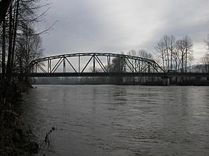
Skykomish River at Monroe, near flood stage
|
|

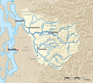
Map of the Skykomish River highlighted in the Snohomish River watershed
|
|
|
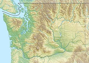
Mouth of the Skykomish River in Washington
|
|
| Country | United States |
| State | Washington |
| County | Snohomish County, King County |
| Physical characteristics | |
| Main source | Confluence of the North and South Forks 47°48′47″N 121°34′41″W / 47.81306°N 121.57806°W |
| River mouth | Snohomish River Monroe 47°49′49″N 122°2′48″W / 47.83028°N 122.04667°W |
| Length | 29 mi (47 km) |
| Basin features | |
| Basin size | 834 sq mi (2,160 km2) |
The Skykomish River is a river about 29-mile (47 km) long in Washington, USA. It flows from the western side of the Cascade Mountains. The river starts where its two main parts, the North Fork Skykomish River and South Fork Skykomish River, meet. This meeting point is near a town called Index.
The Skykomish River then flows northwest towards Puget Sound. Along its way, other rivers like the Sultan River and the Wallace River join it near Sultan. Finally, it meets the Snoqualmie River at Monroe to form the Snohomish River. The Snohomish River then continues its journey to Port Gardner Bay, which is part of Puget Sound.
The Skykomish River and its branches, including the South Fork and Tye River, stretch for about 62.4 miles (100 km). The area of land that drains into the Skykomish River is about 834 square miles (2,160 km2). You can often see U.S. Highway 2 and the BNSF Railway following the river's path. People sometimes call the Skykomish River "Sky River" or "The Sky" for short.
Scientists from the U.S. Geological Survey say that the South Fork is the main source of the Skykomish River. It carries about twice as much water as the North Fork. The name "Skykomish" comes from a native language called Northern Lushootseed. It means "upriver people" and was the name of a local Native American group.
Contents
North Fork Skykomish River: Where Does It Begin?
The North Fork Skykomish River starts high up in the Henry M. Jackson Wilderness. This area is near a place called Dishpan Gap, along the Pacific Crest Trail. It begins as a small stream flowing down from the north side of Skykomish Peak.
The Wild Sky Wilderness helps protect the smaller streams and forests around the North Fork Skykomish. As the river flows, it generally moves southwest from its source. Before it meets Goblin Creek, the river goes through a short but amazing canyon. In this canyon, the water drops over Deer Falls. A little further down, the river flows through an even shorter, twisted canyon at Bear Creek Falls.
What Rivers Join the North Fork?
Several smaller streams and rivers flow into the North Fork Skykomish. These are called tributaries.
- Pass Creek: This creek leads towards Cady Pass.
- Quartz Creek: It flows from Monte Cristo Peak.
- Goblin Creek: This creek also flows from Monte Cristo Peak.
- West Cady Creek
- Troublesome Creek: It flows from Monte Cristo Peak, passes through Blanca Lake, and joins the North Fork below Bear Creek Falls.
- Silver Creek: This creek starts near Silvertip Mountain. It flows past Mineral City, an old mining town, before joining the North Fork.
- Salmon Creek: It joins the North Fork just below another old mining town called Galena.
- Trout Creek: This creek joins the North Fork upstream from the town of Index.
South Fork Skykomish River: Its Journey and Waterfalls
The South Fork Skykomish River begins where the Tye River and the Beckler River meet. This spot is east of the town of Skykomish. From there, the South Fork flows northwest.
Near the town of Skykomish, the Beckler River joins it. West of Skykomish, the Miller River adds its waters. Before the South Fork meets the North Fork, it creates some beautiful waterfalls. These include Eagle Falls, followed by Canyon Falls, and then Sunset Falls.
What Rivers Join the South Fork?
Here are some of the rivers and creeks that flow into the South Fork Skykomish:
- Beckler River: This river joins the South Fork very close to where it begins.
- Rapid River: A branch of the Beckler River.
- Miller River: It joins the South Fork near a place called Miller River.
- Money Creek: This creek joins the South Fork near Grotto.
- Index Creek: It joins the South Fork near Baring.
- Barclay Creek
History of the Skykomish River Area
In the 1890s, the Great Northern Railway built train tracks along the Skykomish River. These tracks followed the South Fork Skykomish and Tye Rivers, crossing the mountains at Stevens Pass. Today, these tracks are owned by BNSF Railway.
Stevens Pass is named after John Frank Stevens, who surveyed the area for the railway. Two long train tunnels, both called Cascade Tunnel, were built at Stevens Pass. The first one was replaced in 1929 by the New Cascade Tunnel. This new tunnel is about 7.8 miles (12.6 km) long. For almost 60 years, it was the longest railroad tunnel in North America!
The western entrance of the New Cascade Tunnel is near where Tunnel Creek meets the Tye River. A small amount of water from both tunnels flows into the Tye River. There's a special place called the Iron Goat Trail interpretive center near Scenic. It tells the story of the old railway and a major train event that happened there, known as the Wellington Disaster.
Native American trails also used to follow the Skykomish and North Fork Skykomish rivers to cross the Cascade Mountains at Cady Pass.
Recreation: Fun on the Skykomish River
The Skykomish River is a popular spot for outdoor activities. Many people enjoy rafting and kayaking on its waters, especially during the summer months near Index, Washington. The river has rapids that are mostly rated Class III or Class III+, which means they are exciting but manageable for many. There's also a more challenging Class IV+ rapid called Boulder Drop.
The Skykomish River and its smaller streams are also great for recreational fishing. The river is home to different types of fish, including chinook, coho, and pink salmon. You can also find steelhead and bull trout here.
Waterfalls of the Skykomish River
The Skykomish River and its forks are home to several beautiful waterfalls.
North Fork Waterfalls
South Fork Waterfalls
 | Tommie Smith |
 | Simone Manuel |
 | Shani Davis |
 | Simone Biles |
 | Alice Coachman |


