Baring, Washington facts for kids
Quick facts for kids
Baring, Washington
|
|
|---|---|

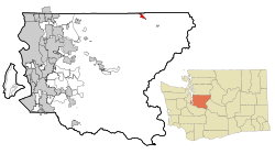
Location of Baring, Washington
|
|
| Country | United States |
| State | Washington |
| County | King |
| Area | |
| • Total | 1.13 sq mi (2.93 km2) |
| • Land | 1.04 sq mi (2.70 km2) |
| • Water | 0.09 sq mi (0.24 km2) |
| Elevation | 774 ft (236 m) |
| Population | |
| • Total | 255 |
| • Density | 211/sq mi (81.6/km2) |
| Time zone | UTC-8 (Pacific (PST)) |
| • Summer (DST) | UTC-7 (PDT) |
| ZIP code |
98224
|
| Area code(s) | 360 |
| FIPS code | 53-04300 |
| GNIS feature ID | 1516134 |
Baring is a small community in King County, Washington, United States. It is a place where the government counts people, called a census-designated place (CDP). In 2020, about 255 people lived there. This was a little more than the 220 people counted in 2010.
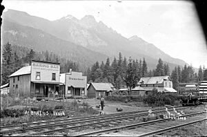
Baring is located on U.S. Highway 2. This highway goes through mountains, but near Baring, it's very flat and straight for about three miles. People sometimes call this part the "Baring Straight." This is a fun play on words, like the Bering Strait between Alaska and Russia. The community was first called "Salmon." But by 1909, it became known as Baring.
Contents
History of Baring
The towns in the Skykomish River valley grew because of railways and roads. These paths helped people cross the Cascade Mountains at Stevens Pass. In the late 1800s, the Great Northern Railway was expanding. Its chief engineer, John F. Stevens, explored the area. He found that Stevens Pass was a great spot for the railway to cross the mountains. The first train came through in June 1893.
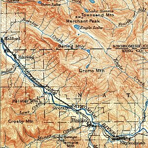
Early roads were also important. The Skykomish Tote Road connected towns along the railway. You can see it in old photos and maps.
Building the Cascade Highway
In 1912, people in Baring wanted better roads. They started a "Good Roads Club." Their goal was to build a highway across the Cascade Mountains. By 1913, King, Chelan, and Snohomish counties worked together. They planned the Cascade Scenic Highway project. This highway was also known as King County Road No. 999.
However, building the highway took a long time. World War I caused delays. There were also problems with money and construction. King County finished its part of the road by 1917. This section was about 28 miles long. But cars could not cross the mountains until 1924. The highway officially opened in July 1925.
The Stevens Pass Highway
The Cascade Scenic Highway and Stevens Pass Highway were very important. They made it easier to travel and connect with other places. In the 1930s, the Stevens Pass Highway became State Road 15. Over time, it was changed, paved, and renamed many times. In the late 1940s, it finally became US 2.
Geography of Baring
Baring is in the northeastern part of King County. It sits in the valley of the South Fork Skykomish River. You can find it at these coordinates: 47°45′50″N 121°28′34″W / 47.76389°N 121.47611°W.
US-2 goes southeast from Baring for about 7 miles to Skykomish. If you go northwest, it's about 41 miles to Everett.
The United States Census Bureau says Baring covers a total area of about 2.9 square kilometers. Most of this area, about 2.7 square kilometers, is land. The rest, about 0.2 square kilometers, is water. This means about 8% of Baring's area is water.
Population and People
| Historical population | |||
|---|---|---|---|
| Census | Pop. | %± | |
| 1910 | 140 | — | |
| 1920 | 71 | −49.3% | |
| 1930 | 111 | 56.3% | |
| 1940 | 105 | −5.4% | |
| 1990 | 161 | — | |
| 2000 | 233 | 44.7% | |
| 2010 | 220 | −5.6% | |
| 2020 | 255 | 15.9% | |
| U.S. Decennial Census | |||
In 2000, there were 233 people living in Baring. They lived in 105 households. About 90% of the people were White. There were also people who identified as Native American, Asian, and Pacific Islander. Some people were from two or more races. About 2% of the population was Hispanic or Latino.
About 20% of the people were under 18 years old. The average age in Baring was 40 years.
Climate in Baring
Baring has an Oceanic climate. This type of climate is often called "Cfb" on climate maps. It means the area has mild summers and cool, wet winters.
| Climate data for Baring (1991–2020 normals, extremes 1970–present) | |||||||||||||
|---|---|---|---|---|---|---|---|---|---|---|---|---|---|
| Month | Jan | Feb | Mar | Apr | May | Jun | Jul | Aug | Sep | Oct | Nov | Dec | Year |
| Record high °F (°C) | 61 (16) |
73 (23) |
80 (27) |
91 (33) |
100 (38) |
107 (42) |
101 (38) |
98 (37) |
98 (37) |
86 (30) |
70 (21) |
60 (16) |
107 (42) |
| Mean maximum °F (°C) | 52.7 (11.5) |
59.4 (15.2) |
67.8 (19.9) |
78.0 (25.6) |
84.7 (29.3) |
86.8 (30.4) |
91.7 (33.2) |
90.9 (32.7) |
85.8 (29.9) |
72.7 (22.6) |
59.0 (15.0) |
51.2 (10.7) |
94.3 (34.6) |
| Mean daily maximum °F (°C) | 41.9 (5.5) |
46.6 (8.1) |
51.6 (10.9) |
58.5 (14.7) |
66.0 (18.9) |
69.4 (20.8) |
76.7 (24.8) |
77.1 (25.1) |
70.9 (21.6) |
58.3 (14.6) |
47.4 (8.6) |
40.8 (4.9) |
58.8 (14.9) |
| Daily mean °F (°C) | 36.7 (2.6) |
39.2 (4.0) |
42.8 (6.0) |
48.2 (9.0) |
55.0 (12.8) |
58.8 (14.9) |
64.4 (18.0) |
64.7 (18.2) |
59.5 (15.3) |
49.9 (9.9) |
41.6 (5.3) |
36.2 (2.3) |
49.8 (9.9) |
| Mean daily minimum °F (°C) | 31.5 (−0.3) |
31.8 (−0.1) |
33.9 (1.1) |
38.0 (3.3) |
44.0 (6.7) |
48.1 (8.9) |
52.1 (11.2) |
52.2 (11.2) |
48.1 (8.9) |
41.5 (5.3) |
35.7 (2.1) |
31.6 (−0.2) |
40.7 (4.8) |
| Mean minimum °F (°C) | 21.8 (−5.7) |
23.3 (−4.8) |
26.4 (−3.1) |
30.9 (−0.6) |
35.4 (1.9) |
41.2 (5.1) |
45.4 (7.4) |
45.0 (7.2) |
39.9 (4.4) |
31.0 (−0.6) |
25.3 (−3.7) |
21.9 (−5.6) |
16.3 (−8.7) |
| Record low °F (°C) | 3 (−16) |
6 (−14) |
16 (−9) |
27 (−3) |
30 (−1) |
31 (−1) |
37 (3) |
38 (3) |
30 (−1) |
23 (−5) |
8 (−13) |
3 (−16) |
3 (−16) |
| Average precipitation inches (mm) | 16.72 (425) |
10.60 (269) |
11.90 (302) |
8.35 (212) |
5.02 (128) |
3.96 (101) |
1.73 (44) |
1.90 (48) |
4.79 (122) |
12.30 (312) |
18.06 (459) |
14.56 (370) |
109.89 (2,791) |
| Average snowfall inches (cm) | 13.8 (35) |
4.6 (12) |
3.8 (9.7) |
0.8 (2.0) |
0.0 (0.0) |
0.0 (0.0) |
0.0 (0.0) |
0.0 (0.0) |
0.0 (0.0) |
0.1 (0.25) |
4.2 (11) |
17.0 (43) |
44.3 (113) |
| Average precipitation days (≥ 0.01 in) | 20.0 | 17.1 | 19.9 | 18.4 | 15.0 | 13.0 | 6.7 | 6.1 | 11.0 | 16.6 | 20.3 | 19.9 | 184.0 |
| Average snowy days (≥ 0.1 in) | 4.7 | 2.1 | 2.4 | 0.3 | 0.0 | 0.0 | 0.0 | 0.0 | 0.0 | 0.1 | 2.4 | 5.1 | 17.1 |
| Source 1: NWS | |||||||||||||
| Source 2: NOAA | |||||||||||||
See also
 In Spanish: Baring (Washington) para niños
 | Selma Burke |
 | Pauline Powell Burns |
 | Frederick J. Brown |
 | Robert Blackburn |


