
Bering Strait facts for kids

The Bering Strait is a narrow stretch of ocean that separates the continents of Asia and North America. It lies between Russia (at Cape Dezhnev) and Alaska, United States (at Cape Prince of Wales). This important waterway is just south of the Arctic Circle.
About 40,000 years ago, during the last ice age, this area was a wide land bridge called Beringia. It connected Asia and North America. As the ice melted, the sea level rose, and Beringia was covered by water, forming the strait we see today. The International Date Line also runs through the strait. This means if you look from the Russian side to the Alaskan side, it's like looking into "tomorrow"!
Geography of the Strait

The Bering Strait is about 82 kilometers wide at its narrowest point. It is also quite shallow, with an average depth of 50 meters. The deepest part is about 90 meters.
There are three small islands in the strait. The two main ones are the Diomede Islands, located right in the middle. Big Diomede Island belongs to Russia, and Little Diomede Island belongs to the United States. The International Date Line runs right between these two islands. There is also a tiny rock called Fairway Rock southeast of the Diomede Islands.
Ideas for a Crossing
For many years, people have thought about building a bridge or tunnel across the Bering Strait. This would be a huge project to connect Alaska and Russia. Cars and trains could then travel between North America and the connected road systems of Asia, Europe, and Africa.
Such a crossing would likely have three main parts. One section would link Big Diomede Island to Russia. Another would connect Little Diomede Island to Alaska. A final link would join the two Diomede Islands.
So far, no actual construction has begun. This is mainly because the strait is in a very remote area. Also, there aren't many major highways or railroads nearby that connect to the rest of Asia or America. If a crossing were built, new roads and railways would also need to be constructed to reach it. However, this idea might become more important in the future.
Images for kids
-
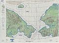
A Defense Mapping Agency map of the Bering Strait from 1973.

See also
 In Spanish: Estrecho de Bering para niños
