
Fairway Rock facts for kids

Fairway Rock is a small, rocky island in the Bering Strait. It has mostly steep sides. You can find it southeast of the Diomede Islands and west of Alaska's Cape Prince of Wales. This island is part of Alaska, a U.S. state. It covers an area of about 0.3 square kilometers (0.12 square miles).
People from the Eskimo groups in the Bering Strait region knew about Fairway Rock long ago. James Cook wrote about it in 1778. Later, Frederick Beechey named it in 1826. No one lives on the island. However, many seabirds nest there, especially least and crested auklets. Local people sometimes visit to collect bird eggs. From the 1960s to the 1990s, the United States Navy placed special equipment on the island. This equipment used radioisotope thermoelectric generators to monitor the environment.
Contents
Geography of Fairway Rock
Fairway Rock is made of granite. It is a leftover from a time when glaciers covered the area. The larger nearby Diomede Islands were also formed this way.
Fairway Rock is located about 12 miles (19 km) southeast of Little Diomede Island. It is also about 20 miles (32 km) west of Cape Prince of Wales. The island is reported to be between 300 meters (980 ft) and 1.5 kilometers (0.93 mi) long.
The island rises steeply from the water. It reaches about 534 feet (163 m) above sea level. You can easily see Fairway Rock from the coast of Alaska at Cape Prince of Wales. Its steep cliffs mean it does not cause extra danger for ships. The Bering Strait around Fairway Rock is fairly shallow, about 50 meters (160 ft) deep.
Scientists sometimes study the ocean currents north of Fairway Rock. They look at how a Von Kármán vortex street is created there. This is a pattern of swirling vortices.
Fairway Rock is part of Alaska's Nome Census Area. It is also in the Alaska Department of Fish and Game Wildlife Conservation Unit 22E. The land belongs to the Inalik Native Corporation. You can find Fairway Rock on United States Geological Survey maps in the Teller Quadrangle.
Flora and Fauna

The island's tall cliffs are a safe place for many migratory birds. Local people have lived nearby for thousands of years. They visit the island in the spring to gather bird eggs. This tradition continued as recently as the 1990s.
About 35,000 seabirds breed on the island. This includes around 25,000 least auklets and crested auklets. In 1925, other birds were seen nesting there. These included the tufted puffin (Fratercula cirrhata) and horned puffin (Fratercula corniculata). Also, parakeet auklets (Aethia psittacula) and Pallas' murre (Uria lomvia arra) nested in the cliff cracks. In 1960, people from Little Diomede said there was a large glaucous gull (Larus hyperboreus) colony on Fairway Rock. It was even bigger than the one on Little Diomede.
The Steller sea lion might also breed on Fairway Rock.
History
Discovery and Naming
For the sake of convenience, I named each of these islands. The eastern one I called Fairway Rock, as it is an excellent guide to the eastern channel, which is the widest and best.
—Capt. Frederick William Beechey, Narrative of a voyage to the Pacific and Beering's Strait to cooperate with the polar expeditions: performed in His Majesty's ship Blossom, pp. 337–338.
Captain James Cook first saw Fairway Rock on August 8, 1778. The English naval officer and mapmaker Frederick William Beechey named it in July 1826. He called it "Fairway" because it was a good guide for ships. Unlike some other names he gave, "Fairway" stuck.
Fairway Rock was mentioned in travel stories. John Muir passed it on his voyage aboard the Corwin in 1881. Roald Amundsen also saw it from the Gjøa in 1906.
In 1964, the U.S. Coast Guard icebreaker USCGC Northwind (WAGB-282) visited the rock. They put an unmanned, propane-powered station there. This station measured water flows across the Bering Strait. The Northwind crew helped keep the station working until it closed.
The Radioisotope Thermoelectric Generator (RTG)

On August 11, 1966, the U.S. Navy placed a special power source on Fairway Rock. It was a strontium-powered radioisotope thermoelectric generator (RTG). This device was used to power instruments that monitored the environment.
The old generator on Fairway Rock used propane. It could not work during the winter. The new RTG was needed quickly. It powered sensors on the ocean floor that watched for submarine traffic. Moving the new generator from Baltimore to Alaska and then to Fairway Rock was a big job.
Commander John C. LeDoux helped make this happen very fast. He got approval to move the generator in just four days. An Air Force flight took it to Alaska. Getting it onto the island was tricky. There were no Navy helicopters nearby. A special pilot was hired. The Army Corps of Engineers set up two places for refueling. A Coast Guard ship (USCGC Northwind (WAGB-282)) went along for safety. The whole trip across the Bering Strait was done safely. The project took only 10 days. It was done mostly with phone calls and visits, not a lot of paperwork.
This device was the first of its kind used by the U.S. government without people watching it. In 1981, two more RTGs were added to the island. All three RTGs were taken off the rock in 1995. This was a joint operation by the Army and Navy. Chinook helicopters from Fort Wainwright, Alaska, helped move them. The RTGs were then taken to the Hanford Nuclear Reservation in Washington state for safe disposal.
Images for kids
-
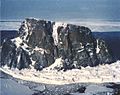
Fairway Rock during the spring of 1989.

See also
 In Spanish: Roca Fairway para niños
