Cape Prince of Wales facts for kids
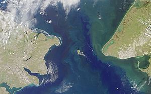
Cape Prince of Wales is the westernmost point of mainland North and South America. It is located in Alaska, United States. This important cape marks the end of the Continental Divide in North America. It also separates the Pacific Ocean from the Arctic Ocean.
Where is Cape Prince of Wales?
Cape Prince of Wales is found on the Seward Peninsula in Alaska. It is very close to the small town of Wales. This cape is a key landmark in the Bering Strait. The Bering Strait is a narrow sea passage that connects the Bering Sea (part of the Pacific) and the Chukchi Sea (part of the Arctic).
The cape is about 51 miles (82 km) away from Cape Dezhnev in Russia. These two capes are the closest points between the continents of North America and Asia. The Diomede Islands and Fairway Rock are also nearby in the Bering Strait.
How the Cape Got Its Name
The cape was first discovered in 1732 by a Russian expedition. This group was led by a military mapmaker named Mikhail Gvozdev. His ship was called Sviatoi Gavriil, which means St. Gabriel. Later, another explorer, Vitus Bering, named the cape after Gvozdev.
In 1778, Captain James Cook of the British Royal Navy gave the cape its current name. He likely named it after George Augustus Frederick, who was the Prince of Wales at that time.
The local Inuit people, specifically the Yupik, had their own name for the cape. It was called Nykhta. This name was written down by G.Sarychev in 1826. The name "Cape Prince of Wales" was officially approved by the USA Board on Geographic Names in 1944.
See also
 In Spanish: Cabo Príncipe de Gales para niños
 | Delilah Pierce |
 | Gordon Parks |
 | Augusta Savage |
 | Charles Ethan Porter |


