Diomede Islands facts for kids

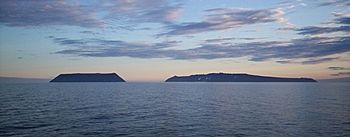
Diomede Islands: Little Diomede (left, U.S.) and Big Diomede,(right, Russia) viewed from the north, looking south
|
|

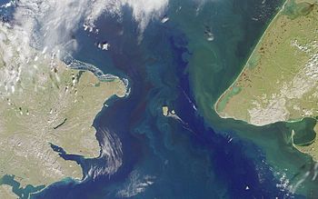
Satellite photo of the Bering Strait, with the Diomede Islands at center
|
|
| Geography | |
| Location | Bering Strait |
| Coordinates | 65°47′N 169°01′W / 65.783°N 169.017°W |
| Total islands | 2 |
| Area | 35 km2 (14 sq mi) |
| Administration | |
| Demographics | |
| Population |
|
| Additional information | |
| Time zones |
|
The Diomede Islands are two small, rocky islands found in the middle of the Bering Strait. This strait is a narrow waterway that separates Alaska (part of the United States) from Siberia (part of Russia). These islands are also known in Russia as the Gvozdev Islands.
There are two main islands:
- The Russian island of Big Diomede, also called Imaqłiq or Ratmanov Island.
- The U.S. island of Little Diomede, also called Iŋaliq or Krusenstern Island.
The Diomede Islands are located between the Chukchi Sea to the north and the Bering Sea to the south. They are famous because the International Date Line runs between them. This means Big Diomede is almost a full day ahead of Little Diomede! Because of this time difference, people sometimes call Big Diomede "Tomorrow Island" and Little Diomede "Yesterday Island."
Contents
Why Are They Called Diomede Islands?
The islands are named after a Greek saint, Saint Diomedes. A Danish explorer named Vitus Bering first saw these islands on August 16, 1728. This was the day the Russian Orthodox Church celebrates Saint Diomedes.
Where Are the Diomede Islands Located?
The two islands are separated by an international border. This border is also where the International Date Line passes through. The closest distance between the two islands is about 3.8 km (2.4 mi).
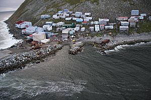
The small village on Little Diomede Island is located on the west side. Big Diomede Island is the easternmost point of Russia.
During winter, a bridge of ice often forms between the two islands. In theory, you could walk from the United States to Russia across this ice. However, it is not allowed to travel between the islands this way.
History of the Diomede Islands
The first European to explore the Bering Strait was a Russian explorer named Semyon Dezhnev in 1648. He mentioned seeing two islands with native people.
Later, in 1728, Vitus Bering officially rediscovered the Diomede Islands. A few years after that, in 1732, a Russian mapmaker named Mikhail Gvozdev accurately mapped the islands.
The Border Between Nations
In 1867, the United States bought Alaska from Russia. The treaty that made this deal official used the Diomede Islands to draw the border. It stated that the border would run exactly in the middle of Little Diomede (Krusenstern Island) and Big Diomede (Ratmanov Island).
During the Cold War, a time of tension between the United States and the Soviet Union, this border was very strict. People called it the "Ice Curtain".
However, in 1987, an amazing swimmer named Lynne Cox swam from one island to the other. Both the leaders of the United States and the Soviet Union praised her for this brave act.
Life on the Islands
After 1948, the Soviet government moved the native people from Big Diomede Island to mainland Russia. Today, only military units live on Big Diomede.
Little Diomede still has a small population of Inupiat people. In 2010, about 115 people lived there. The village has a school, a post office, and a store. Some residents are known for their beautiful ivory carving. When the weather is good, planes bring supplies and people to the island.
See also
 In Spanish: Islas Diómedes para niños
 | Aurelia Browder |
 | Nannie Helen Burroughs |
 | Michelle Alexander |


