
Nome Census Area, Alaska facts for kids
Quick facts for kids
Nome Census Area
|
|
|---|---|
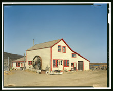
Iditarod Trail Shelter Cabins, Cape Nome Roadhouse, Cape Nome
|
|

Location within the U.S. state of Alaska
|
|
.svg) Alaska's location within the U.S. |
|
| Country | |
| State | |
| Established | 1980 |
| Named for | Nome |
| Largest city | Nome |
| Area | |
| • Total | 28,278 sq mi (73,240 km2) |
| • Land | 22,962 sq mi (59,470 km2) |
| • Water | 5,316 sq mi (13,770 km2) 18.8%% |
| Population
(2020)
|
|
| • Total | 10,046 |
| • Estimate
(2022)
|
9,835 |
| • Density | 0.355259/sq mi (0.137166/km2) |
| Time zone | UTC−9 (Alaska) |
| • Summer (DST) | UTC−8 (ADT) |
| Congressional district | At-large |
The Nome Census Area is a special part of Alaska, USA. It covers most of the Seward Peninsula. In 2020, about 10,046 people lived here. This was more than the 9,492 people in 2010. It's part of an "unorganized borough," which means it doesn't have a main government town like other areas. The biggest town in the area is Nome.
Contents
Geography of Nome Census Area
The Nome Census Area is very large! It covers about 28,278 square miles (73,240 square kilometers). Most of this area, about 22,962 square miles (59,470 square kilometers), is land. The rest, about 5,316 square miles (13,770 square kilometers), is water. This means almost 19% of the area is water.
The area also includes a big island called St. Lawrence Island. About 14% of the people in the Nome Census Area live on this island. Two of its larger towns, Gambell and Savoonga, are found there. The Nome Census Area is the seventh largest "county-equivalent" area in Alaska.
Neighboring Areas
The Nome Census Area shares borders with other parts of Alaska and even another country:
- Northwest Arctic Borough, Alaska - to the north
- Yukon-Koyukuk Census Area, Alaska - to the east
- Kusilvak Census Area, Alaska - to the south
- Chukotsky District, Chukotka Autonomous Okrug (in Russia) - to the west
Protected Natural Areas
Some parts of the Nome Census Area are protected to keep nature safe. These include:
- Alaska Maritime National Wildlife Refuge (part of the Bering Sea unit)
- Bering Land Bridge National Preserve (part)
- Yukon Delta National Wildlife Refuge (part)
- Andreafsky Wilderness (part)
People of Nome Census Area
The population of the Nome Census Area has changed over the years.
| Historical population | |||
|---|---|---|---|
| Census | Pop. | %± | |
| 1960 | 6,091 | — | |
| 1970 | 5,749 | −5.6% | |
| 1980 | 6,537 | 13.7% | |
| 1990 | 8,288 | 26.8% | |
| 2000 | 9,196 | 11.0% | |
| 2010 | 9,492 | 3.2% | |
| 2020 | 10,046 | 5.8% | |
| 2023 (est.) | 9,763 | 2.9% | |
| U.S. Decennial Census 1790-1960 1900-1990 1990-2000 2010-2020 |
|||
Population in 2020
In 2020, the United States Census collected information about the people living in the Nome Census Area. Here's a look at the different groups:
| Race | Percentage of Population |
|---|---|
| White | 21.83% |
| Black or African American | 1.16% |
| American Indian or Alaska Native | 82.57% |
| Asian | 2.19% |
| Native Hawaiian and Other Pacific Islander | 0.37% |
| Some other race | 1.26% |
Towns and Villages
The Nome Census Area has several towns and villages.
Cities
Census-Designated Place
- Port Clarence is a place the census bureau uses for gathering data.
Unincorporated Communities
These are small communities that are not officially organized as cities or towns:
- Haycock
- Solomon
Images for kids
-
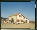
Iditarod Trail Shelter Cabins, Cape Nome Roadhouse, Cape Nome
See also
 In Spanish: Área censal de Nome para niños
