Kusilvak Census Area, Alaska facts for kids
Quick facts for kids
Kusilvak Census Area
|
|
|---|---|

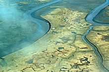
Aerial view of Tutakoke Bird Camp, Coast of the Bering Sea just south of Hooper Bay, near Chevak, Alaska.
|
|

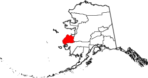
Location within the U.S. state of Alaska
|
|
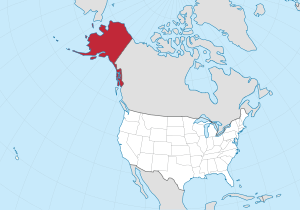
 Alaska's location within the U.S. |
|
| Country | |
| State | |
| Established | 1980 |
| Named for | Kusilvak Mountains |
| Largest city | Hooper Bay |
| Area | |
| • Total | 19,673 sq mi (50,950 km2) |
| • Land | 17,081 sq mi (44,240 km2) |
| • Water | 2,592 sq mi (6,710 km2) 13.2%% |
| Population
(2020)
|
|
| • Total | 8,278 |
| • Density | 0.44/sq mi (0.17/km2) |
| Time zone | UTC−9 (Alaska) |
| • Summer (DST) | UTC−8 (ADT) |
| Congressional district | At-large |
The Kusilvak Census Area is a special part of Alaska, a state in the United States. It used to be called the Wade Hampton Census Area. This area is not like a regular county with its own government. Instead, it's part of something called the Unorganized Borough. This means it doesn't have a main "county seat" or capital city.
In 2020, about 8,368 people lived here. That's more than the 7,459 people who lived there in 2010. The biggest town in the Kusilvak Census Area is Hooper Bay. It is located right on the coast of the Bering Sea.
The Kusilvak Census Area is known for having a lower average income compared to other places in the U.S. In 2014, it also had a higher number of people who were looking for jobs but couldn't find them.
Contents
History of Kusilvak Census Area
This area was first named after a person called Wade Hampton III. He was a politician from South Carolina. In 1913, a judge in Alaska named a mining area after him. This area later became the census area we know today.
Over time, many people felt that the name "Wade Hampton" was not right for Alaska. Wade Hampton III had owned enslaved people and was a general in the American Civil War. Many Native residents and others felt his history did not fit the region.
So, in July 2015, the Governor of Alaska, Bill Walker, officially changed the name. The area was renamed after the Kusilvak Mountains. These are the tallest mountains in the region.
Geography of Kusilvak
The Kusilvak Census Area is quite large. According to the U.S. Census Bureau, it covers about 19,673 square miles. Most of this area, about 17,081 square miles, is land. The rest, about 2,592 square miles, is water. This means about 13.2% of the area is covered by water.
Nearby Areas and Protected Lands
The Kusilvak Census Area shares borders with other parts of Alaska:
- To the north is the Nome Census Area, Alaska.
- To the east is the Yukon–Koyukuk Census Area, Alaska.
- To the south is the Bethel Census Area, Alaska.
A large part of the Yukon Delta National Wildlife Refuge is also located here. This refuge is a special place that protects wildlife. Inside it, there's also a wilderness area called Andreafsky Wilderness.
People of Kusilvak Census Area
The number of people living in the Kusilvak Census Area has grown steadily over the years.
| Historical population | |||
|---|---|---|---|
| Census | Pop. | %± | |
| 1960 | 3,128 | — | |
| 1970 | 3,917 | 25.2% | |
| 1980 | 4,665 | 19.1% | |
| 1990 | 5,791 | 24.1% | |
| 2000 | 7,028 | 21.4% | |
| 2010 | 7,459 | 6.1% | |
| 2020 | 8,368 | 12.2% | |
| 2023 (est.) | 8,001 | 7.3% | |
| U.S. Decennial Census 1790–1960 1900–1990 1990–2000 2010–2020 |
|||
In 2000, there were 7,028 people living in the area. Most people, about 92.53%, identified as Native American. About 4.74% were White. A small number of people were from other racial backgrounds.
Many people in the area speak Central Alaskan Yup'ik. About 49.75% of the population spoke Yup'ik at home in 2000. The other 50% spoke English.
The Kusilvak Census Area has a very young population. In 2000, almost half of the people, 46.60%, were under 18 years old. This is the highest percentage for any county-like area in the United States. The average age was 20 years old, making it the youngest county in the U.S.
How Diverse is Kusilvak?
Here's a look at the different racial groups in the Kusilvak Census Area from the 2020 census:
| Race | Percentage of Population |
|---|---|
| White | 3.84% |
| Black or African American | 0.65% |
| American Indian or Alaska Native | 96.93% |
| Asian | 0.55% |
| Native Hawaiian and Other Pacific Islander | 0.29% |
| Some other race | 0.42% |
Towns and Villages in Kusilvak
The Kusilvak Census Area is home to several communities. These include cities, census-designated places, and unincorporated villages.
Cities
- Alakanuk
- Chevak
- Emmonak
- Hooper Bay
- Kotlik
- Marshall
- Mountain Village
- Nunam Iqua (formerly Sheldon Point)
- Pilot Station
- Russian Mission
- Scammon Bay
- St. Mary's
Census-designated place
Unincorporated Communities
- Bill Moore's Slough
- Chuloonawick
- Hamilton
- Ohogamiut
See also
 In Spanish: Área censal de Wade Hampton para niños
 | Selma Burke |
 | Pauline Powell Burns |
 | Frederick J. Brown |
 | Robert Blackburn |

