
Bering Land Bridge National Preserve facts for kids
Quick facts for kids Bering Land Bridge National Preserve |
|
|---|---|
|
IUCN Category V (Protected Landscape/Seascape)
|
|

Serpentine Tors
|
|

Bering Land Bridge National Preserve
Location in Alaska
|
|
| Location | Seward Peninsula, Alaska, United States |
| Nearest city | Kotzebue, Alaska |
| Area | 2,697,391 acres (10,915.95 km2) |
| Created | December 1, 1978 |
| Visitors | 2,642 (in 2018) |
| Governing body | National Park Service |
| Website | Bering Land Bridge National Preserve |
The Bering Land Bridge National Preserve is a very remote national park area in Alaska. It's located on the Seward Peninsula. This special preserve protects a part of the famous Bering Land Bridge. This land bridge once connected Asia with North America over 13,000 years ago. This was during the Pleistocene ice age, a time when huge glaciers covered much of the Earth.
Most of this ancient land bridge is now under the waters of the Chukchi and Bering Seas. During the ice age, when sea levels were much lower, this bridge was a highway. It was used by people, animals, and plants to travel between continents. Scientists still discuss if early humans first came to the Americas across this land bridge, also called Beringia, or by a coastal route.
The Bering Land Bridge National Monument was created in 1978 by the President. In 1980, it became a national preserve. This change allowed local people to continue hunting for food and for sport. The preserve has important archaeological sites and amazing geological features. It also shows signs of recent volcanic activity, like lava flows and lakes formed in volcanic craters called maars. Hot springs are a popular spot for visitors.
Contents
Exploring the Preserve's Geography
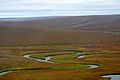
The preserve is located on the northern side of the Seward Peninsula. It covers a huge area of about 2.7 million acres. The preserve stretches along the coast from near Deering to Cape Espenberg. It then goes westward along the shore of the Chukchi Sea. The preserve's inland parts reach the Continental Divide and the Bendeleben Mountains. This area includes volcanic spots like Serpentine Hot Springs and lava fields. The highest point in the preserve is Mount Boyan.
There are no roads to get into the preserve. You can reach it by small planes or boats in the summer. In winter, people use ski planes, snowmobiles, or dog sleds. The preserve has several important geological and historical sites. Serpentine Hot Springs is the most visited place. Other cool spots include the Trail Creek Caves, Devil Mountain Lakes, and the Lost Jim Lava Flow.
-
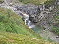
Dorothy Falls
-
Copper Canyon
-
Cottonwood
-
Kuzitrin Lake
.jpg)
.jpg)
.jpg)
.jpg)
Volcanoes and Rocks
The Seward Peninsula is a piece of the ancient Beringia landmass. This landmass connected Alaska and Siberia when sea levels were low during the ice ages. Most of this region was not covered by glaciers during the ice age. The preserve has five main types of landscapes: a northern coastal plain, rolling hills, a lava plateau, flat areas, and mountains.
The Seward Peninsula is mostly made of metamorphic rocks called blueschist. It also has sand, gravel, silt, and some moraines left by glaciers. Along the coast, you can see old beach ridges. These form lagoons and sandbars. The rolling hills are further inland. The Serpentine Hot Springs and Trail Creek Caves are in this area, which has limestone and other minerals.

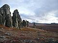
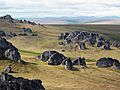
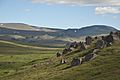
Volcanic activity in the preserve's interior has left areas of basalt rock. Some of this activity was recent. The Lost Jim lava flow is only about 1,000 to 2,000 years old. It came from about 75 vents, with the largest being the Lost Jim Cone, which is about 75 feet tall. Hot springs are another sign of this volcanic past. The Serpentine Hot Springs have water temperatures from 140°F to 170°F. Local people have used them for thousands of years. Granite tors are also volcanic remnants. They formed underground and were later uncovered by erosion. The preserve has the four largest and northernmost maar lakes in the world at Cape Espenberg. These round craters formed from volcanic explosions.
The action of ice and permafrost (permanently frozen ground) creates unique features. These include polygonal ice wedges and pingos (ice-cored hills).
Serpentine Hot Springs
Serpentine Hot Springs is also known as Iyat or Uunaatuq in the Inupiaq language. Iyat means "cooking pot." These springs are in the northern part of the Seward Peninsula. They are located on the right bank of Hot Springs Creek, which flows into the Serpentine River.
-
Serpentine rocks
-
Serpentine Tors
-
Serpentine Tors
-
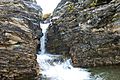
Serpentine Falls
.jpg)
_Photo1_resize_(16085999268).jpg)
.jpg)
.jpg)
History of the Area
The Serpentine Hot Springs were first described by Arthur J. Collier in 1902. Charles McLennan was likely the first non-Native person to reach the springs in 1900. Miners used the area off and on until about 1915. They built a cabin, bathhouse, and a bathing pool. A runway might have been built in 1923, and a bunkhouse was brought in by workers in 1949. In 1953, the nearby village of Shishmaref received money to build a public bathhouse.
It is believed that the springs were used by Inupiat people for a very long time. They used them for cooking, healing, and spiritual purposes. Anthropologists who studied the Inupiat in the area reported that local people believed the hot springs had strong healing powers.

The Seward Peninsula was a pathway for Asian peoples to migrate into the Americas. The oldest human-made items found here are animal bones from about 13,000 BC. The clearest proof of human life comes from the Trail Creek Caves. These items date back to between 10,000 and 7,000 BC.
Later cultures, like the Denbigh culture (4000 to 2000 BC), left behind tools at Cape Espenberg and other sites. The Choris culture followed, bringing pottery and new stone tools. Then came the Ipuitak culture. These cultures lived in many of the same places.
From 600 AD to the early 1800s, different cultures lived in the area. Their traditional ways of life changed when Europeans arrived. The fur trade, whaling, and missionary activities changed the local economy. In the late 1800s, gold prospectors came to the Seward Peninsula. They spread across the peninsula, and some even used hydraulic mining in the Pinnel River area. More outsiders came during World War II, as Alaska was important in the Pacific war.

Amazing Wildlife and Plants
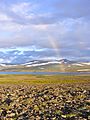
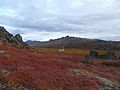
Most of the land in the preserve is tundra, with permafrost underneath. The tundra supports many low-growing plants. Grasses and sedges, like cottongrass, are common. Large trees cannot grow on the tundra. Only dwarf species like Arctic willow, Alaska willow, and dwarf birch can survive.
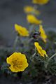
Berry plants in the preserve include bog blueberry, crowberry, low-bush cranberry, and cloudberry. Lichens grow in rocky areas. Many types of mosses and liverworts are also found. In spring, the preserve bursts with wildflowers. These include Alpine Arnica, fireweed, and alpine forget-me-not.
-
Potentilla uniflora
-
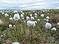
Eriophorum angustifolium
-
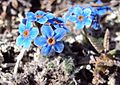
Eritrichium nanum
.jpg)
.jpg)
.jpg)
.jpg)
.jpg)
.jpg)
Caribou are animals that survived the ice age in the preserve. Muskoxen were brought back to the area in 1970 after they had disappeared in the early 1900s. Besides native caribou, Siberian tundra reindeer were also introduced in 1894. Their population grew to 600,000 in the 1930s but is now about 4,000.
Other mammals in the preserve include walruses, polar bears, red foxes, brown bears, Arctic foxes, ribbon seals, wolverines, and beavers. Important nesting birds include sandhill cranes and yellow-billed loons.
-
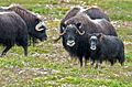
Muskox family

.jpg)
.jpg)
.jpg)
.jpg)
.jpg)
The rivers and streams of the Seward Peninsula are home to freshwater fish and anadromous salmon. Anadromous fish live in saltwater but return to freshwater to lay eggs. The main salmon species are chinook, coho, sockeye, chum, and pink salmon. Other fish like Dolly Varden trout and Arctic grayling stay in freshwater their whole lives. The preserve also has northern pike and other fish.
-
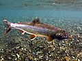
Dolly Varden trout
.jpg)
_(cropped).jpg)
.jpg)
.jpg)
The preserve has typical northwestern Alaska weather. Winters are long and cold, with temperatures sometimes reaching -65°F. Summer temperatures average about 50°F. The average yearly temperature is 21°F.
Muskoxen Mass Death in 2011
In February 2011, a whole herd of 55 muskoxen died in a storm in the National Preserve. The herd was crossing a bay in the Kotzebue Sound. They were caught by surprise by a strong tidal surge and flooding during a winter storm. When the water rushed in, it broke the ice under them. The herd fell into the freezing water. The temperature was below -30°C, and all the muskoxen died and froze in the ice. Researchers found them because four of the animals had radio collars. Besides this preserve, muskoxen also live in Gates of the Arctic National Park and Preserve. There is also a muskox farm in Palmer.
|
