Kotzebue, Alaska facts for kids
Quick facts for kids
Kotzebue
Qikiqtaġruk
|
||
|---|---|---|

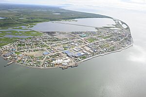
Aerial view of Kotzebue
|
||
|
||
| Motto(s):
"Gateway to the Arctic" "An All American City"
|
||

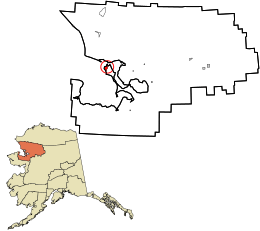
Location in Northwest Arctic Borough and the state of Alaska.
|
||
| Country | United States | |
| State | Alaska | |
| Borough | Northwest Arctic | |
| Incorporated | October 14, 1958 | |
| Government | ||
| • Type | Council-manager | |
| Area | ||
| • Total | 26.50 sq mi (68.64 km2) | |
| • Land | 24.76 sq mi (64.12 km2) | |
| • Water | 1.75 sq mi (4.52 km2) | |
| Elevation | 20 ft (6 m) | |
| Population
(2020)
|
||
| • Total | 3,102 | |
| • Density | 125.30/sq mi (48.38/km2) | |
| Time zone | UTC−9 (AKST) | |
| • Summer (DST) | UTC−8 (AKDT) | |
| ZIP code |
99752
|
|
| Area code | 907 | |
| FIPS code | 02-41830 | |
| GNIS feature ID | 1413378 | |
| Website | City of Kotzebue, Alaska | |
Kotzebue (pronounced KOTS-ə-bew) is a city in Alaska, a state in the United States. Its native name is Qikiqtaġruk, which means "big island." Kotzebue is the main city in the Northwest Arctic Borough. It is the biggest community there and an important center for business and travel. In 2020, about 3,102 people lived in Kotzebue.
Contents
Exploring Kotzebue's Past
Early History and Name Origins
People called Iñupiat have lived in Kotzebue for a very long time. Archeologists have found proof they were here since at least the 1400s. Because of its good location and size, Kotzebue became a busy place for trading and gathering. People from nearby rivers like the Noatak, Selawik, and Kobuk came here. Even people from the Russian Far East traveled to trade. They exchanged things like furs, seal oil, animal hides, and weapons. People also gathered for fun events, like the ones you see at the World Eskimo Indian Olympics today. When whalers, traders, and gold seekers arrived, the trading center grew even more.
The city's original name, Qikiqtaġruk, comes from the Iñupiaq language. Kotzebue got its current name from the nearby Kotzebue Sound. This sound was named after Otto von Kotzebue. He was a Baltic German explorer who searched for the Northwest Passage in 1818.
Key Moments in Kotzebue's History
In 1897, people started bringing reindeer to the area. Even though Alaska had wild caribou (which are like reindeer), these domesticated reindeer came from Asia. A United States post office opened in Kotzebue in 1899.
Later, in 1991, the film Salmonberry was filmed in Kotzebue. A very important event happened on September 2, 2015. U.S. President Barack Obama visited Kotzebue to talk about climate change. He was the first sitting president to visit a place north of the Arctic Circle.
Discovering Kotzebue's Location
Kotzebue is built on a gravel strip of land called a spit. This spit is at the end of the Baldwin Peninsula, right in the Kotzebue Sound. It is about 30 miles (48 km) from other small towns like Noatak and Kiana. Kotzebue is located about 33 miles (53 km) north of the Arctic Circle on Alaska's western coast.
The city covers about 28.7 square miles (74.3 sq km) in total. Most of this area, about 27.0 square miles (69.9 sq km), is land. The remaining 1.6 square miles (4.1 sq km) is water.
Kotzebue is home to the NANA Regional Corporation. This is one of thirteen corporations created to manage land claims for Alaska Native people. Kotzebue is also a great starting point for visiting Kobuk Valley National Park. The Northwest Arctic Heritage Center in town helps visitors learn about the park. The Selawik National Wildlife Refuge also has an office here.
Kotzebue's Weather and Climate
Kotzebue has a very dry subarctic climate. This means it has long, very cold winters with some snow. The summers are short and mild. The average temperature in February is about -3.5°F (-19.7°C). In July, it's around 54.7°F (12.6°C). The average temperature for the whole year is about 21.8°F (-5.7°C).
It usually rains most in the summer months. The city gets about 10.1 inches (25.7 cm) of precipitation each year. Snowfall is usually light, with about 39 inches (99 cm) per season. The coldest temperature ever recorded was -58°F (-50°C). The warmest was 85°F (29°C).
| Climate data for Kotzebue, Alaska | |||||||||||||
|---|---|---|---|---|---|---|---|---|---|---|---|---|---|
| Month | Jan | Feb | Mar | Apr | May | Jun | Jul | Aug | Sep | Oct | Nov | Dec | Year |
| Record high °F (°C) | 39 (4) |
40 (4) |
39 (4) |
48 (9) |
71 (22) |
85 (29) |
85 (29) |
80 (27) |
69 (21) |
57 (14) |
40 (4) |
37 (3) |
85 (29) |
| Mean daily maximum °F (°C) | 3.7 (−15.7) |
3.0 (−16.1) |
7.2 (−13.8) |
19.6 (−6.9) |
37.8 (3.2) |
50.8 (10.4) |
60.0 (15.6) |
56.7 (13.7) |
46.4 (8.0) |
27.5 (−2.5) |
13.3 (−10.4) |
6.0 (−14.4) |
27.7 (−2.4) |
| Mean daily minimum °F (°C) | −8.6 (−22.6) |
−9.9 (−23.3) |
−7.7 (−22.1) |
3.3 (−15.9) |
25.3 (−3.7) |
38.8 (3.8) |
49.4 (9.7) |
47.4 (8.6) |
37.2 (2.9) |
18.8 (−7.3) |
3.2 (−16.0) |
−6.4 (−21.3) |
15.9 (−8.9) |
| Record low °F (°C) | −55 (−48) |
−52 (−47) |
−58 (−50) |
−44 (−42) |
−12 (−24) |
20 (−7) |
30 (−1) |
26 (−3) |
13 (−11) |
−19 (−28) |
−37 (−38) |
−49 (−45) |
−58 (−50) |
| Average precipitation inches (mm) | .55 (14) |
.42 (11) |
.38 (9.7) |
.41 (10) |
.33 (8.4) |
.57 (14) |
1.43 (36) |
2.00 (51) |
1.70 (43) |
.95 (24) |
.71 (18) |
.60 (15) |
10.05 (255) |
| Average snowfall inches (cm) | 5.6 (14) |
4.3 (11) |
3.9 (9.9) |
3.9 (9.9) |
1.2 (3.0) |
trace | trace | trace | 1.0 (2.5) |
5.8 (15) |
6.5 (17) |
7.1 (18) |
39.3 (100) |
| Average precipitation days (≥ 0.01 in) | 8.5 | 6.9 | 6.7 | 6.5 | 5.5 | 5.9 | 9.9 | 14.0 | 12.3 | 10.9 | 9.5 | 9.6 | 106.2 |
| Average snowy days (≥ 0.1 in) | 7.8 | 6.5 | 6.0 | 6.5 | 2.1 | .1 | 0 | 0 | 1.1 | 7.4 | 8.6 | 8.9 | 55.0 |
| Source: NOAA (normals, 1971−2000), Weather.com (extremes) | |||||||||||||
People of Kotzebue
| Historical population | |||
|---|---|---|---|
| Census | Pop. | %± | |
| 1880 | 200 | — | |
| 1910 | 193 | — | |
| 1920 | 230 | 19.2% | |
| 1930 | 291 | 26.5% | |
| 1940 | 372 | 27.8% | |
| 1950 | 623 | 67.5% | |
| 1960 | 1,290 | 107.1% | |
| 1970 | 1,696 | 31.5% | |
| 1980 | 2,054 | 21.1% | |
| 1990 | 2,751 | 33.9% | |
| 2000 | 3,082 | 12.0% | |
| 2010 | 3,201 | 3.9% | |
| 2020 | 3,102 | −3.1% | |
| U.S. Decennial Census | |||
Kotzebue first appeared on the U.S. Census in 1880. It was then called "Kikiktagamute." The city officially became a town in 1958.
In 2000, there were 3,082 people living in Kotzebue. About 71% of the people were American Indian (mostly Iñupiat). About 20% were White, and other groups made up the rest. Many households had children under 18 living with them. The average household had about 3 to 4 people.
Kotzebue's Important Services
Getting Around: Transportation
Ralph Wien Memorial Airport is Kotzebue's airport. It is the only airport in the Northwest Arctic Borough with regular flights. You can fly from here to Ted Stevens Anchorage International Airport and the Nome Airport.
News and Radio: Media
The Arctic Sounder is a weekly newspaper. It covers news for Kotzebue and the surrounding Northwest Arctic Borough. It also covers the North Slope Borough.
KOTZ is the local public radio station. It broadcasts at 720 AM. KOTZ helps connect Kotzebue with other communities in the borough.
Learning in Kotzebue: Education
The Northwest Arctic Borough School District runs two schools in Kotzebue. These are June Nelson Elementary School (JNES) and Kotzebue Middle High School (KMHS). In 2017, these were the largest schools in the district.
There is also a private school called Nikaitchuat Iḷisaġviat. The Native Village of Kotzebue runs this school. It teaches young children (Pre-K to first grade) using the Iñupiaq language.
The University of Alaska Fairbanks (UAF) has a campus here called Chukchi Campus. It offers classes, a library, and other services for the community.
Famous People from Kotzebue
Many interesting people have come from Kotzebue. Here are a few:
- Willie Hensley (born 1941): He was a state representative and senator. He helped create the NANA Regional Corporation. He was also important in passing the Alaska Native Claims Settlement Act.
- Reggie Joule (born 1952): He served many terms in the Alaska House of Representatives. He was also the borough mayor. He became famous for his skills in the World Eskimo Indian Olympics. He even appeared on The Tonight Show Starring Johnny Carson twice.
- John Baker (born c. 1962): He won the 2011 Iditarod Trail Sled Dog Race.
Understanding "Toxins" in Kotzebue
You might hear that Kotzebue is listed as a place with a lot of "toxins." This can sound scary, but it's important to understand why. The United States Environmental Protection Agency (EPA) tracks certain releases. In 2016, a report said Kotzebue "produced" a huge amount of toxins. This made it seem like the most "toxic" place in the U.S.
However, these "toxins" don't actually come from Kotzebue itself. As National Geographic explained, the source is the Red Dog mine. This mine is one of the world's largest zinc and lead mines. It is located about 80 miles (129 km) north of Kotzebue. The EPA sometimes links releases from remote places to the nearest city. So, even though the mine is far away, its releases were connected to Kotzebue in the report. This means the city itself is not producing these substances.
See also
 In Spanish: Kotzebue (Alaska) para niños
 | Dorothy Vaughan |
 | Charles Henry Turner |
 | Hildrus Poindexter |
 | Henry Cecil McBay |


