Deering, Alaska facts for kids
Quick facts for kids
Deering
Ipnatchiaq
|
|
|---|---|

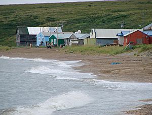
Houses along the Chukchi Sea in Deering
|
|

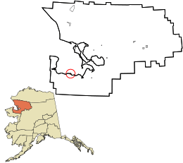
Location in Northwest Arctic Borough and the state of Alaska.
|
|
| Country | United States |
| State | Alaska |
| Borough | Northwest Arctic |
| Incorporated | October 28, 1970 |
| Area | |
| • Total | 5.09 sq mi (13.18 km2) |
| • Land | 5.02 sq mi (12.99 km2) |
| • Water | 0.07 sq mi (0.19 km2) |
| Elevation | 7 ft (2 m) |
| Population
(2020)
|
|
| • Total | 182 |
| • Density | 36.28/sq mi (14.01/km2) |
| Time zone | UTC-9 (Alaska (AKST)) |
| • Summer (DST) | UTC-8 (AKDT) |
| ZIP code |
99736
|
| Area code | 907 |
| FIPS code | 02-18510 |
| GNIS feature ID | 1412894 |
Deering (Inupiaq: Ipnatchiaq or Ipnasiaq) is a small city in Alaska, a state in the United States. It is found in the Northwest Arctic Borough. Deering is located on a sandy strip of land called a spit. This spit is where the Inmachuk River meets Kotzebue Sound. It is about 92 km (57 mi) southwest of Kotzebue.
In 2020, 182 people lived in Deering. This was more than the 136 people who lived there in 2000. The city has a community hall, a health clinic, a post office, a church, and two stores. It also has a National Guard building called an armory.
Contents
Culture and Community Life
Most people living in Deering are Iñupiat. The Iñupiat are Native Alaskans. They are very active in subsistence. This means they get most of their food and supplies directly from nature. They hunt, fish, and gather plants. This way of life is very important to their culture.
A Look at Deering's History
Deering started in 1901. It was a place to get supplies for gold miners. It was first called "Yutica." It was close to an old Eskimo village named Inmachukmiut. The name "Deering" likely came from a ship. This ship was called the Abbie M. Deering. It was in the area around that time. Deering officially became a city in 1970. It also has a city council. This council helps the community make decisions.
Where is Deering? (Geography)
Deering is located at these coordinates: 66°4′33″N 162°43′6″W / 66.07583°N 162.71833°W. This means it is in the northern part of Alaska. It is on the Seward Peninsula. The city's total area is about 13.18 square kilometres (5.09 sq mi). Most of this area is land, with a small part being water.
Deering's Weather (Climate)
Deering has a cold climate. It is located in the Arctic region. The weather changes a lot throughout the year. Summers are cool, and winters are very cold.
| Climate data for Deering, Alaska (1991–2020) | |||||||||||||
|---|---|---|---|---|---|---|---|---|---|---|---|---|---|
| Month | Jan | Feb | Mar | Apr | May | Jun | Jul | Aug | Sep | Oct | Nov | Dec | Year |
| Record high °F (°C) | 52 (11) |
57 (14) |
49 (9) |
54 (12) |
70 (21) |
78 (26) |
85 (29) |
81 (27) |
65 (18) |
58 (14) |
46 (8) |
45 (7) |
85 (29) |
| Mean maximum °F (°C) | 32.8 (0.4) |
36.0 (2.2) |
30.4 (−0.9) |
41.0 (5.0) |
56.5 (13.6) |
70.9 (21.6) |
75.7 (24.3) |
69.9 (21.1) |
59.6 (15.3) |
47.7 (8.7) |
36.1 (2.3) |
33.5 (0.8) |
76.7 (24.8) |
| Mean daily maximum °F (°C) | 3.8 (−15.7) |
9.1 (−12.7) |
8.1 (−13.3) |
21.9 (−5.6) |
40.4 (4.7) |
55.7 (13.2) |
62.0 (16.7) |
57.3 (14.1) |
48.4 (9.1) |
33.6 (0.9) |
20.5 (−6.4) |
9.5 (−12.5) |
30.9 (−0.6) |
| Daily mean °F (°C) | −3.9 (−19.9) |
0.7 (−17.4) |
−0.1 (−17.8) |
14.4 (−9.8) |
33.1 (0.6) |
46.9 (8.3) |
53.7 (12.1) |
49.8 (9.9) |
41.4 (5.2) |
27.5 (−2.5) |
12.8 (−10.7) |
1.7 (−16.8) |
23.2 (−4.9) |
| Mean daily minimum °F (°C) | −11.6 (−24.2) |
−7.8 (−22.1) |
−8.3 (−22.4) |
6.9 (−13.9) |
25.8 (−3.4) |
38.1 (3.4) |
45.4 (7.4) |
42.4 (5.8) |
34.4 (1.3) |
21.3 (−5.9) |
5.1 (−14.9) |
−6.1 (−21.2) |
15.5 (−9.2) |
| Mean minimum °F (°C) | −35.5 (−37.5) |
−33.5 (−36.4) |
−27.6 (−33.1) |
−14.2 (−25.7) |
10.5 (−11.9) |
27.7 (−2.4) |
35.8 (2.1) |
30.5 (−0.8) |
21.9 (−5.6) |
5.3 (−14.8) |
−16.0 (−26.7) |
−29.5 (−34.2) |
−39.2 (−39.6) |
| Record low °F (°C) | −47 (−44) |
−48 (−44) |
−36 (−38) |
−25 (−32) |
−9 (−23) |
21 (−6) |
29 (−2) |
25 (−4) |
16 (−9) |
−15 (−26) |
−30 (−34) |
−43 (−42) |
−48 (−44) |
| Average precipitation inches (mm) | 0.11 (2.8) |
0.14 (3.6) |
0.03 (0.76) |
0.17 (4.3) |
0.21 (5.3) |
0.43 (11) |
1.68 (43) |
1.82 (46) |
0.87 (22) |
0.37 (9.4) |
0.13 (3.3) |
0.08 (2.0) |
6.04 (153) |
| Average precipitation days (≥ 0.01 in) | 3.4 | 3.4 | 1.5 | 3.2 | 4.4 | 6.3 | 12.9 | 13.4 | 11.6 | 6.7 | 3.7 | 3.1 | 73.6 |
| Source: NOAA | |||||||||||||
Who Lives in Deering? (Demographics)
| Historical population | |||
|---|---|---|---|
| Census | Pop. | %± | |
| 1910 | 100 | — | |
| 1920 | 73 | −27.0% | |
| 1930 | 183 | 150.7% | |
| 1940 | 230 | 25.7% | |
| 1950 | 174 | −24.3% | |
| 1960 | 95 | −45.4% | |
| 1970 | 85 | −10.5% | |
| 1980 | 150 | 76.5% | |
| 1990 | 157 | 4.7% | |
| 2000 | 136 | −13.4% | |
| 2010 | 122 | −10.3% | |
| 2020 | 182 | 49.2% | |
| U.S. Decennial Census | |||
Deering first appeared in the U.S. Census in 1910. It became an official city in 1970.
In 2000, there were 136 people living in Deering. Most of the people (over 93%) were Native American, mainly Iñupiat. A small number of people were White or of two or more races.
The average household in Deering had about three people. Many households (40.5%) had children under 18 living there. The median age of people in Deering was 27 years old. This means half the people were younger than 27, and half were older.
The Abbie M. Deering Ship
The city of Deering might be named after a ship called the Abbie M. Deering. A book from 1900 tells the story of this ship. Twenty men bought it to sail to the "Alaskan Gold Fields" during the Klondike Gold Rush. They left Lynn, Massachusetts in November 1897. They sailed around South America and reached San Francisco five months later. They sold the ship there.
Records show the ship did make it to Alaska. It was lost near the Aleutian Islands in September 1903. The famous writer Rudyard Kipling even mentioned the Abbie M. Deering in his 1897 novel Captains Courageous.
Learning in Deering (Education)
The Deering School serves the children of the community. It is run by the Northwest Arctic Borough School District. In 2017, the school had 4 teachers and 50 students. All of the students were Alaska Natives.
See also

- In Spanish: Deering (Alaska) para niños
 | DeHart Hubbard |
 | Wilma Rudolph |
 | Jesse Owens |
 | Jackie Joyner-Kersee |
 | Major Taylor |

