
Aleutian Islands facts for kids
| Geography | |
|---|---|
| Location | Pacific Ocean, Bering Sea |
| Administration | |
| Demographics | |
| Population | 8,162 |
The Aleutian Islands are a long chain of over 300 small islands. Most of these islands were formed by volcanoes. They stretch across the northern Pacific Ocean, creating a natural border between the cold Bering Sea and the large Gulf of Alaska. The name "Aleutian" might come from a word meaning "island."
These islands are very far west, reaching almost from the Alaska Peninsula in the United States towards the Kamchatka Peninsula in Russia. They even cross the 180th meridian, which means they are the furthest west part of the United States. Almost all the islands belong to Alaska. However, the Commander Islands at the very western end are part of Russia.
The Aleutian Islands are home to 57 volcanoes. This makes them an important part of the "Pacific Ring of Fire." This is an area around the Pacific Ocean where many earthquakes and volcanic eruptions happen. The Alaska Marine Highway, a ferry system, also travels through these islands.
About 8,200 people live on the US part of the islands. They live in 11 towns or villages spread across seven different islands. Around 600 people live on the Russian side of the islands.
Images for kids
-
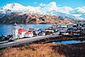
Unalaska Island in the Aleutian Islands.
-
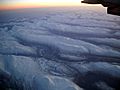
The Aleutian Islands seen from high up in the sky.
-
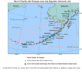
Active Aleutian volcanoes.
-
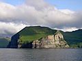
Cape Promontory, Cape Lutkes on Unimak Island in the Aleutian Islands, Alaska.
-
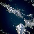
An image of the islands taken by astronauts from the STS-56 space mission.
-
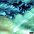
These cloud formations were seen over the western Aleutian Islands.
-

An image of the islands taken by the ASTER satellite.
-
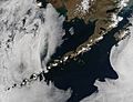
The Aleutian Islands on May 15, 2014, as seen by NASA's Aqua satellite.


.jpg)

See also
 In Spanish: Islas Aleutianas para niños
