
Unimak Island facts for kids
|
Native name:
Unimax
|
|
|---|---|

Unimak Island from space, September 1992 (viewed from Shuttle Endeavour on STS-47)
|
|

Unimak
Location in Alaska
|
|
| Geography | |
| Location | Northern Pacific Ocean |
| Coordinates | 54°46′06″N 164°11′12″W / 54.76833°N 164.18667°W |
| Archipelago | Aleutian Islands |
| Area | 1,571.41 sq mi (4,069.9 km2) |
| Length | 95 km (59 mi) |
| Width | 116 km (72.1 mi) |
| Highest elevation | 9,373 ft (2,856.9 m) |
| Highest point | Mount Shishaldin |
| Administration | |
| State | Alaska |
| Borough | Aleutians East |
| Demographics | |
| Population | 64 (2000) |
| Pop. density | 0.02 /km2 (0.05 /sq mi) |

Unimak Island is the largest island in the Aleutian Islands chain. This island is part of the U.S. state of Alaska. Its name in the Aleut language is Unimax.
Contents
Geography of Unimak Island
Unimak Island is the most eastern island in the Aleutians. It covers an area of about 1,571 square miles (4,070 square kilometers). This makes it the ninth largest island in the United States. It is also the 134th largest island in the world.
Volcanoes and Landforms
Unimak Island is home to Mount Shishaldin. This is one of the ten most active volcanoes in the world. It is a tall, cone-shaped volcano.
The Fisher Caldera is a large volcanic crater on the island. It is located in the west-central part of Unimak. This area has many small volcanic cones. It also has lakes that do not drain into rivers. The caldera is named after Bernard Fisher. He was a geologist who died nearby.
Mount Westdahl is another volcano on Unimak Island. It is about 5,426 feet (1,654 meters) tall. This volcano is located at the western end of the island.
Population and Capes
According to the 2000 United States Census, 64 people lived on Unimak Island. All of them lived in the city of False Pass. This small city is at the eastern end of the island.
Cape Lutke is a headland on the island. A headland is a piece of land that sticks out into the sea. Cape Pankof is another headland. It is located at the very southwest tip of the island.
Wildlife and Nature on Unimak Island
A large part of Unimak Island is protected land. In 1980, about 910,000 acres (368,000 hectares) of the island became a wilderness area. This area is managed by the United States Fish and Wildlife Service. It is part of the Alaska Maritime National Wildlife Refuge. This means the land is kept wild to protect its animals and plants.
Animals of Unimak Island
Unimak Island has many different land mammals. This is because it is connected to the Alaska Peninsula. You can find Alaska Peninsula brown bears here. There are also porcupine caribou, which are a type of reindeer.
West of Unimak Island, the largest native mammal is the red fox. This shows how the types of animals change as you move further into the Aleutian Islands.
Important Structures on Unimak Island
Unimak Island has a history of important buildings, especially lighthouses.
Lighthouses
The Scotch Cap Lighthouse was built in 1903. It was operated by the U.S. Coast Guard. On April 1, 1946, a large tsunami hit the lighthouse. This happened during the 1946 Aleutian Islands earthquake. Even though the lighthouse was 98 feet (30 meters) above the sea, the powerful wave pulled it into the ocean. Five Coast Guard workers lost their lives in this event.
The Cape Sarichef Lighthouse is also located on Unimak Island.
Airports
- Cape Sarichef Airport
Images for kids
-
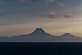
Shishaldin, Isanotski and Roundtop volcanoes as seen from the Unimak Pass in morning light.
-
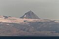
Pogramni (6569ft, 2002m) volcano as seen from the Unimak Pass in morning light.
-
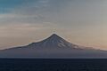
Shishaldin (9373ft, 2857m) volcano as seen from the Unimak Pass in morning light.
-
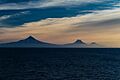
Isanotski (8104ft, 2470m) and Roundtop (6128ft, 1871m) volcanoes as seen from the Unimak Pass in morning light.


See also
 In Spanish: Isla Unimak para niños
