
Cape Espenberg facts for kids


Cape Espenberg is a piece of land that sticks out into the Chukchi Sea in Alaska. It's located on the Seward Peninsula.
This cape points north. It is about 42 miles (68 km) northwest of Deering. On its southeast side, you'll find Goodhope Bay, which is part of the Kotzebue Sound.
A naval officer named Otto von Kotzebue gave the cape its name in 1816. He named it after Dr. Karl Espenberg. Dr. Espenberg was a surgeon who traveled around the world with Captain Adam Johann von Krusenstern between 1803 and 1806.
Cape Espenberg is right on the Arctic Circle. It's at the end of a long, flat beach area, about 30 km (19 miles) long. This area is the northernmost part of the Seward Peninsula in western Alaska.
The cape faces the wide Chukchi Sea. This sea can have open water for 1,000 km (620 miles). However, ice usually covers the sea for part of the year. In recent years, the ice cover has been getting shorter.
Contents
How Cape Espenberg Was Formed
Cape Espenberg is a place where a lot of sand and sediment collect. This happens because of strong winds from the west and northwest. These winds create a system that moves sand along the coast for about 200 km (124 miles).
Sandy Beaches and Lagoons
There's a lot of sand available offshore. This sand forms sandy barrier islands along most of the northwest coast of the Seward Peninsula. These islands stretch from the Bering Strait all the way into Kotzebue Sound. They create many large lagoons behind them.
The Chukchi Sea doesn't have very big tides, usually less than 50 cm (20 inches). Strong currents from the west help keep sandbars offshore. These sandbars usually reduce the power of waves hitting the shore.
Storms and Sand Movement
Sometimes, especially in the fall, strong storm surges happen. These are like very high tides caused by storms. The water level can rise 3 to 4 meters (10 to 13 feet) during these events.
The beaches at Cape Espenberg are very flat. They are made of fine and medium sand. You might also find a few scattered rocks. These rocks likely arrived on ice that floated to the area.
Sand dunes are found behind the beach. Grass helps to hold these dunes in place. They can reach a height of about 4 meters (13 feet).
Where Does the Sand Come From?
Geologists believe the sand comes from several places. Much of it is fine quartz sand. This sand is densest on the shallow seafloor north of the Bering Strait. It has a long and complex history. A lot of sand from the Yukon River flowed into the southern Chukchi Sea a long time ago. This sand helped form and reshape the early barrier islands.
Another source of sand might be from ancient rivers like the Noatak and Kobuk. These rivers once flowed across the land bridge called Beringia when sea levels were lower. This sand was then reshaped into dunes during the Ice Age.
Darker, medium-sized sand comes from the erosion of cliffs nearby. These cliffs were formed by a volcanic eruption about 17,000 years ago. This eruption created a maar.
New sand is brought to the shore during the five-month period when the water is open, from June to November. Over thousands of years, sand has generally moved onto the land, building up the beaches. However, storms and changes in currents can cause sand to move offshore, leading to erosion of the beaches. In recent years, some beaches have become narrower and shallower.
Things Found on the Beach
You can find many interesting things on the beach. These include bones from ancient animals like horses, bison, or mammoths. You might also find modern and old seashells.
Driftwood, mostly spruce trees, gathers on the storm beach and in channels that cut across the beach ridges. This wood travels from the forested areas along the Yukon River. Cottonwood and birch trees are rare.
Sometimes, currents reverse direction due to easterly winds. This can cause beach erosion. When this happens, you might see starfish and eelgrass from the lagoons washed up on the beach.
Dunes and Climate
Cape Espenberg is located in a tundra region. Sand dunes form along the beach because the sand dries out in winter. Onshore winds in late spring also help. A type of beach grass that can survive being buried by sand helps to stabilize the dunes.
Taller dunes are linked to more intense storms that happened during the Little Ice Age. These dunes contain layers of shells that were deposited during storm surges. Strong storms caused erosion across the land between 1000 BC and AD 200, and again during the Little Ice Age.
The beach area is about 1 km (0.6 miles) northwest of the cape's navigational light. It is mostly untouched by people. The National Park Service limits the use of motor vehicles there. The area is almost empty of people. The closest settlement is about 10 km (6 miles) away. It has a few cabins used by Inupiat hunters and fishers during certain seasons.
History of Human Settlement
Cape Espenberg has a rich history of human activity going back over 4,000 years. Archaeologists have been studying the area since the 1950s. J. Louis Giddings first visited the cape then.
Archaeological Discoveries
The National Park Service has done surveys and excavations at the cape. Researchers have found small sites and large villages with many old house foundations in the Espenberg dunes. Scientists have used over 120 radiocarbon dates to create a timeline of the cultures that lived there.
Since 2007, several research projects have been funded by the National Science Foundation. These projects are led by John F. Hoffecker, Owen K. Mason, and Claire M. Alix. The dunes hold amazing information about how buildings changed over time and how cultures adapted to climate changes. The earliest people lived at the cape around 2500 BCE. They were the first to adapt to a maritime (sea-based) way of life along the northern Alaska coast.
Ancient Metal Artifacts
In 2011, archaeologists made an exciting discovery at Cape Espenberg. They found metal objects, including a bronze buckle. This buckle was likely made in East Asia, either Siberia or farther south.
These metal items were found near a house where the Birnirk people lived. The Birnirk people are believed to be the ancestors of today's Inuit people. Experts at Purdue University studied the metal. They found that the objects were not made locally.
The metal was brought to Cape Espenberg at least 500 years before Europeans had regular contact with the area in the late 1700s. The buckle itself wasn't directly dated. However, it was attached to a leather strap. This strap was dated to around AD 1200 using radiocarbon dating.
Images for kids
-
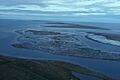
Barrier islands and lagoons at Cape Espenberg
-
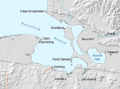
Map showing Kotzebue Sound and Cape Espenberg
