
Solomon, Alaska facts for kids
Quick facts for kids
Solomon, Alaska
Aaŋuutaq
|
|
|---|---|
|
Former mining camp
|
|
| Country | United States |
| State | Alaska |
| Census Area | Nome Census Area |
| Population
(2010)
|
|
| • Total | 0 |

Solomon (in Inupiaq: Aaŋuutaq) was a small community in Alaska. It was located in the Nome Census Area, which is part of the Unorganized Borough of Alaska. In 2010, the population of Solomon was zero. This means no one lived there at that time. Before that, in 2000, four people lived there.
The Solomon State Field Airport is very close to where Solomon used to be. The land there is about 23 feet (7 meters) above sea level. The closest big town to Solomon is Nome.
Contents
The History of Solomon
Solomon was first settled by the Fish River tribe. Later, in the early 1900s, it became a busy place for mining. It grew into a town around that time.
Early Days and Challenges
The first post office in Solomon opened in 1900. Otto Weihe was the first postmaster. He was in charge of the mail for the town.
In 1913, a very strong storm hit Solomon. This storm destroyed the local railroad and most of the town. People who survived the storm had to move. They went to a nearby place called Dickson, which had recently been left empty.
A few years later, in 1918, a serious illness spread around the world. This was the Spanish flu epidemic. It also reached Solomon, affecting the people living there.
Population Changes in Solomon
| Historical population | |||
|---|---|---|---|
| Census | Pop. | %± | |
| 1940 | 106 | — | |
| 1950 | 93 | −12.3% | |
| 1980 | 4 | — | |
| 1990 | 6 | 50.0% | |
| 2000 | 4 | −33.3% | |
| 2010 | 0 | −100.0% | |
| U.S. Decennial Census | |||
Solomon first appeared in the U.S. Census in 1940. At that time, 106 people lived there. In 1950, the population was 93. After that, it wasn't counted again until 1980.
By 2010, no one lived in Solomon. However, some people still own cabins there. They use these cabins during certain times of the year.
About the Area
The schools for this area are part of the Bering Strait School District. This district is based in Unalakleet. The old settlement of Dickson was right across the Solomon River.
Solomon is about 30 miles (48 kilometers) east of Nome. The Nome-Council Highway is the only road that goes through Solomon. The Solomon State Field Airport is a gravel airstrip. Small planes use it for charter flights from Nome.
There is also a small place to stay in Solomon, like a bed and breakfast. It is open in the summer. Government survey teams often use it when they are working in the area.
Images for kids
-
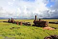
The last train to nowhere, a famous sight along the Nome to Council Road, at the Solomon Bridge at Mile 33.
-
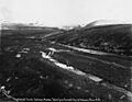
Creek viewed from Council City and Solomon River Railroad
-
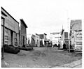
Main Street
-
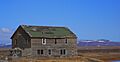
Ol' Man Pete Curran's Store

.jpg)
.jpeg)

