
Port Clarence, Alaska facts for kids
Quick facts for kids
Port Clarence, Alaska
|
|
|---|---|

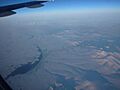
Bering Strait. Port Clarence bay is the large bight in the southeast.
|
|

Location of Port Clarence, Alaska
|
|
| Country | United States |
| State | Alaska |
| Census Area | Nome |
| Area | |
| • Total | 35.02 sq mi (90.71 km2) |
| • Land | 34.05 sq mi (88.20 km2) |
| • Water | 0.97 sq mi (2.51 km2) |
| Elevation | 16 ft (5 m) |
| Population
(2020)
|
|
| • Total | 0 |
| • Density | 0.00/sq mi (0.00/km2) |
| Time zone | UTC-9 (Alaska (AKST)) |
| • Summer (DST) | UTC-8 (AKDT) |
| ZIP code |
99762
|
| Area code(s) | 907 |
| FIPS code | 02-63170 |
| GNIS feature ID | 1408213 |
Port Clarence is a special area in Alaska, located in the Nome Census Area. It is a census-designated place (CDP), which means it's a community identified by the census bureau. This area sits on a narrow strip of land that separates Port Clarence Bay from the vast Bering Strait. According to the 2020 census, no one lives there anymore, but it has an interesting history. In 2010, 24 people lived there, showing a big change over time.
Contents
A Look Back: History of Port Clarence
Port Clarence has a rich past, playing different roles throughout the years.
Early Days and Reindeer
In 1897, a missionary named Sheldon Jackson had a very successful Teller Reindeer Station at Port Clarence. This station became famous during the Overland Relief Expedition. This expedition was a rescue mission to save whalers who were stuck near Point Barrow.
During the gold rush in Nome from 1898 to 1899, people also found smaller amounts of gold and high-quality tin in Port Clarence.
In 1899, the Harriman Alaska Expedition visited Port Clarence. They took many photographs, creating an important record of the Alaska Natives who lived there.
The United States Coast and Geodetic Survey mapped the coastline of Port Clarence in 1900. This helped sailors and explorers understand the area better.
From 1961 to 2010, Port Clarence was home to a LORAN-C station. This station was managed by the United States Coast Guard. LORAN-C was a special radio navigation system that helped ships and planes know exactly where they were. The LORAN-C program ended on February 8, 2010. The station had a very tall tower, about 1,350 feet (411.48 meters) high, built in 1961. It was the tallest structure in Alaska until it was taken down in 2010.
Where is Port Clarence? Geography Explained
Port Clarence is located at coordinates 65°15′58″N 166°51′10″W / 65.26611°N 166.85278°W. This means it's quite far north in Alaska!
The area covers about 36.5 square miles (90.71 square kilometers). Most of this area, about 35.5 square miles (88.20 square kilometers), is land. The rest, about 1.0 square mile (2.51 square kilometers), is water.
Who Lived Here? Population Changes
Port Clarence has seen many changes in its population over the years. It first appeared in the U.S. Census in 1890 as an area with 485 residents. At that time, the census included people from several small native villages and even some ships in the area.
After 1890, Port Clarence was not counted separately again until 1980. It was then designated as a census-designated place (CDP).
The population numbers have varied:
- In 1980, there were 29 people.
- In 1990, the population was 26.
- By 2000, it had decreased to 21 people.
- In 2010, the population slightly increased to 24.
- However, by the 2020 census, the population was 0. This means no one officially lived in Port Clarence at that time.
| Historical population | |||
|---|---|---|---|
| Census | Pop. | %± | |
| 1890 | 485 | — | |
| 1980 | 29 | — | |
| 1990 | 26 | −10.3% | |
| 2000 | 21 | −19.2% | |
| 2010 | 24 | 14.3% | |
| 2020 | 0 | −100.0% | |
| U.S. Decennial Census | |||
Weather in Port Clarence: Climate Facts
Port Clarence experiences a subarctic climate, which is a type of climate found in very cold regions. It's almost like a tundra climate, known for its long, cold winters and short, cool summers.
| Climate data for Port Clarence, Alaska | |||||||||||||
|---|---|---|---|---|---|---|---|---|---|---|---|---|---|
| Month | Jan | Feb | Mar | Apr | May | Jun | Jul | Aug | Sep | Oct | Nov | Dec | Year |
| Record high °F (°C) | 42 (6) |
45 (7) |
35 (2) |
48 (9) |
64 (18) |
76 (24) |
81 (27) |
80 (27) |
72 (22) |
51 (11) |
43 (6) |
35 (2) |
81 (27) |
| Mean daily maximum °F (°C) | 9.4 (−12.6) |
4.7 (−15.2) |
7.2 (−13.8) |
20.7 (−6.3) |
36.1 (2.3) |
48.9 (9.4) |
56.5 (13.6) |
54.2 (12.3) |
46.6 (8.1) |
33.1 (0.6) |
20.3 (−6.5) |
10.7 (−11.8) |
29.0 (−1.7) |
| Daily mean °F (°C) | 2.8 (−16.2) |
−1.6 (−18.7) |
1.0 (−17.2) |
12.9 (−10.6) |
30.2 (−1.0) |
43.1 (6.2) |
50.9 (10.5) |
49.8 (9.9) |
41.8 (5.4) |
29.1 (−1.6) |
15.4 (−9.2) |
4.7 (−15.2) |
23.3 (−4.8) |
| Mean daily minimum °F (°C) | −3.8 (−19.9) |
−8.1 (−22.3) |
−5.5 (−20.8) |
5.1 (−14.9) |
24.4 (−4.2) |
37.2 (2.9) |
45.4 (7.4) |
44.8 (7.1) |
36.9 (2.7) |
24.9 (−3.9) |
10.5 (−11.9) |
−1.4 (−18.6) |
17.5 (−8.1) |
| Record low °F (°C) | −44 (−42) |
−48 (−44) |
−36 (−38) |
−28 (−33) |
−6 (−21) |
20 (−7) |
20 (−7) |
25 (−4) |
18 (−8) |
−5 (−21) |
−12 (−24) |
−30 (−34) |
−48 (−44) |
| Average precipitation inches (mm) | 1.11 (28) |
1.47 (37) |
0.15 (3.8) |
0.46 (12) |
0.27 (6.9) |
0.70 (18) |
0.98 (25) |
1.82 (46) |
1.48 (38) |
0.92 (23) |
0.64 (16) |
1.26 (32) |
11.26 (286) |
| Average snowfall inches (cm) | 4.4 (11) |
11.7 (30) |
3.0 (7.6) |
1.9 (4.8) |
0.4 (1.0) |
0.0 (0.0) |
0.0 (0.0) |
0.0 (0.0) |
0.0 (0.0) |
3.5 (8.9) |
5.2 (13) |
6.4 (16) |
36.5 (93) |
| Source: WRCC | |||||||||||||
Images for kids
-
The Bering Sea shore just south-east of Port Clarence

See also
 In Spanish: Port Clarence (Alaska) para niños
