
Cape Nome facts for kids

Cape Nome is a piece of land that sticks out into the sea, like a small peninsula. It's located in Alaska, a U.S. state. You can find it on the northern shore of Norton Sound, about 15 miles east of the city of Nome. It's surrounded by water on some sides: Norton Sound to the south, Hastings Creek to the west, and a lagoon and rivers to the east. From the coast, Cape Nome stretches inland for about 4 miles and is connected to Nome by road.
Contents
How Cape Nome Got Its Name
Cape Nome has had a few different names over time! In 1833, a person named Mikhail Tebenkov called it Tolstoi, which means "blunt" or "broad." Later, in 1852, a Russian map called it Sredul, meaning "middle."
The name "Nome" first appeared on British maps around 1849. It was used by Henry Kellett, a British explorer. Some people think the name "Nome" might have come from a mistake. A geographer named George Davidson suggested that someone might have misread a note that said "? Name" as "C. Nome."
A Look Back: Cape Nome's History
Cape Nome is about 129 miles southeast of the Bering Strait. This strait is a narrow waterway that separates North America from Asia. Scientists believe that a land bridge once connected these two continents. People from both sides might have met and traded goods thousands of years ago.
Explorers like Commodore Joseph Billings and Otto van Kotzebue explored areas near Cape Nome in the late 1700s and early 1800s. Later, a trading post was set up at St. Michael. This post was about 130 miles by sea or 225 miles by land from Cape Nome.
Before gold was found, a mission was already at Cape Nome. It even had a government reindeer herd! But everything changed in 1898 when gold was discovered on the Snake River. Miners quickly rushed to the area. On October 18, 1898, the Cape Nome mining precinct was officially created.
There was also an Inuit village at the cape. It had about 80 people. The village was called Ayacheruk, though maps sometimes spelled it Aiacheruk.
Exploring Cape Nome's Geography

Cape Nome is a rocky piece of land that sticks out from the Seward Peninsula. East of Cape Nome, the coastline has large lagoons, which are shallow bodies of water separated from the sea by sandbars. West of Cape Nome, the shoreline is mostly straight.
Near the coast, between the Sinuk River and Cape Nome, there's a flat area about 700 feet high. The land around Cape Nome is often called "tundra gravels." This is a crescent-shaped lowland that stretches from Cape Nome to the hills west of Cripple River.
Cape Nome's Population Over Time
| Historical population | |||
|---|---|---|---|
| Census | Pop. | %± | |
| 1880 | 60 | — | |
| 1890 | 41 | −31.7% | |
| U.S. Decennial Census | |||
The U.S. Census first recorded Cape Nome in 1880. It was listed as an Inuit village called "Ayacheruk." At that time, 60 people lived there, all Inuit.
In 1890, the census recorded Cape Nome again. It included the native villages of Ahyoksekawik (Ayacheruk) and Kogluk. The population had dropped to 41 people, all of whom were native. After 1890, Cape Nome was no longer listed separately in the census.
The Rocks and Land of Cape Nome

Cape Nome is known for its interesting rock formations. It has large granite formations, which are very hard, coarse-grained rocks. There are also "greenstone" formations. These greenstones are like long, thin sheets of rock that have pushed into other rock types, like limestone and schist.
The seaward side of Cape Nome shows a lot of these granite formations. You can also find other types of rocks mixed in, like porphyritic rocks with large feldspar crystals. Tiny crystals of allanite, epidote, and other minerals like chlorite and albite can also be seen. Sometimes, small amounts of quartz fill in cracks in the feldspar crystals.
Scientists have studied the rocks of Cape Nome to understand their age and how they formed. They've found that the granite here is very old, forming over millions of years. In 1947, geologists looked for special minerals in the Cape Nome granites, but they didn't find any radioactive minerals or allanite at that time.
Digging into the Past: Archaeology at Cape Nome
Between 1970 and 1976, archaeologists dug up parts of Cape Nome. They found evidence that different groups of people lived here at different times. They dug over 300 pits to learn about the "Late Norton" and "Early Norton" phases of civilization. These discoveries helped them understand a culture called the "Pre-Birnirk culture," which they named the "Cape Nome Phase."
Images for kids
-
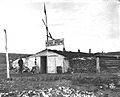
Cape Nome roadhouse, 1901

