
Snoqualmie River facts for kids
Quick facts for kids Snoqualmie River |
|
|---|---|

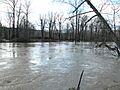
Snoqualmie River flooding several miles below Snoqualmie Falls in December 2004
|
|

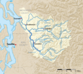
Map of the Snoqualmie River highlighted in the Snohomish River watershed
|
|


Location of the mouth of the Snoqualmie River in Washington
|
|
| Country | United States |
| State | Washington |
| Counties | King, Snohomish |
| Physical characteristics | |
| Main source | Confluence of the Middle and North Forks 47°31′15″N 121°46′33″W / 47.52083°N 121.77583°W |
| River mouth | Snohomish River 47°49′11″N 122°1′45″W / 47.81972°N 122.02917°W |
| Length | 45 mi (72 km) |
| Basin features | |
| Tributaries |
|
| Official name: Snoqualmie (Middle Fork) | |
| Type: | Wild, Scenic |
| Designated: | December 19, 2014 |
The Snoqualmie River is a 45-mile (72 km) long river in Washington state. It flows through King County and Snohomish County. The river gets its water from three main branches: the North, Middle, and South Forks. These branches start in the Cascade Mountains.
The three forks meet near the town of Snoqualmie. Just after they join, the river plunges over the famous Snoqualmie Falls. After the falls, the Snoqualmie River flows north through rich farmland. It passes through towns like Fall City, Carnation, and Duvall. Finally, it meets the Skykomish River to form the Snohomish River near Monroe. The Snohomish River then flows into Puget Sound at Everett.
Other smaller rivers that join the Snoqualmie River include the Taylor River and the Pratt River. These both flow into the Middle Fork. The Tolt River joins near Carnation, and the Raging River joins at Fall City. Much of the Snoqualmie River's water comes from melting snow in the Alpine Lakes Wilderness.
Contents
What are the Main Branches of the Snoqualmie River?
The Snoqualmie River has three important branches, called forks. They are the South Fork, Middle Fork, and North Fork. Each fork starts in the mountains and flows down to meet the main river.
South Fork: Where Does it Begin?

The South Fork is about 31 miles (50 km) long. It starts from a small place called Source Lake, located at 47°27′18″N 121°27′9″W / 47.45500°N 121.45250°W. It flows mostly northwest until it joins the main Snoqualmie River. This happens just above Snoqualmie Falls. Along its path, the South Fork drops over six different waterfalls.
Middle Fork: A Popular Outdoor Area

The Middle Fork is about 41 miles (66 km) long. It begins at Chains Lakes, at 47°33′30″N 121°14′15″W / 47.55833°N 121.23750°W. It flows south to Williams Lake, then east. It meets the North Fork near North Bend. The Taylor River and Pratt River also add their water to the Middle Fork. The upper parts of the Middle Fork, Taylor, and Pratt river valleys are inside the Alpine Lakes Wilderness area.
The Middle Fork Valley is a very popular place for outdoor activities. People like to visit it even in winter because it's not too high up and is close to Seattle. A road called the Middle Fork Road goes deep into the valley. Parts of this road were built on old railroad tracks from the 1920s and 1930s. The valley was heavily logged, meaning trees were cut down, from 1923 through the 1970s.
North Fork: Starting at Lake Kanim
The North Fork is about 28 miles (45 km) long. It starts at a small lake called Lake Kanim, at 47°39′41″N 121°28′58″W / 47.66139°N 121.48278°W. Right after leaving the lake, it flows over Kanim Falls. The river then flows east before turning north. Before it joins the Middle Fork, it flows through a canyon near Ernie's Grove. This canyon has several waterfalls, including Fantastic Falls.
Famous Waterfalls of the Snoqualmie River
The Snoqualmie River and its branches have many beautiful waterfalls.
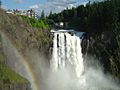
Snoqualmie Falls: A Washington Landmark

The most famous waterfall is Snoqualmie Falls. It is 268-foot (82 m) high. Over a million people visit it every year. It was even shown on the TV show Twin Peaks.
Other Notable Waterfalls
The three forks of the Snoqualmie River also have important waterfalls:
- The North Fork has Fantastic Falls (35 feet high) and Kanim Falls (200 feet high).
- The Middle Fork has Nellie Falls (150 feet high).
- The South Fork has several waterfalls, including Twin Falls (135 feet high), Weeks Falls, Franklin Falls (135 feet high), and Fall-into-the-Wall Falls (22 feet high).
Water Sports on the Snoqualmie River
The Snoqualmie River is a great place for whitewater kayaking and rafting. Different parts of the river offer different levels of difficulty, from easy (Class II) to very challenging (Class V+). The nearby Raging River also has a good kayaking spot.
How Does the Snoqualmie River Flood?

The Snoqualmie River often floods. This usually happens multiple times each year. When it floods, it covers local farmland and closes roads that are low to the ground. During very big floods, all roads to the towns of Carnation and Duvall can be completely closed. This happened in 2020, 2009, 2006, and 1990.
The river's water level is watched by six special stations called USGS streamgages. These stations are on each fork, just above the falls, and near Carnation and Duvall. The information from these stations helps the National Weather Service predict floods and warn people. The Tolt River and Raging River also have these monitoring stations.
To help reduce flooding in the town of Snoqualmie, a project called the Snoqualmie Flood Reduction Project was finished in 2005. This project, done by the Army Corps of Engineers, made the river wider just above the falls.
Images for kids
-
Snoqualmie River flooding several miles below Snoqualmie Falls in December 2004
-
Map of the Snoqualmie River highlighted in the Snohomish River watershed
-
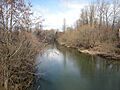
The Middle Fork Snoqualmie River, looking north from State Route 202 near North Bend
-
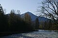
The Middle Fork Snoqualmie River near North Bend. Mount Washington is in the background.
-
Snoqualmie Falls and Salish Lodge
-
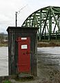
Stream Gaging Station, Carnation, during the March 13, 2007 flood
See also
 In Spanish: Río Snoqualmie para niños
