Snoqualmie, Washington facts for kids
Quick facts for kids
Snoqualmie, Washington
|
|
|---|---|
|
City
|
|
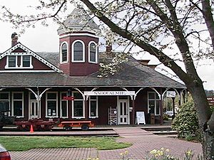
Snoqualmie Depot
|
|
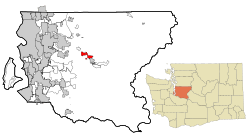
Location within King County
|
|
| Country | United States |
| State | Washington |
| County | King |
| Government | |
| • Type | Mayor–council |
| Area | |
| • Total | 7.42 sq mi (19.22 km2) |
| • Land | 7.18 sq mi (18.59 km2) |
| • Water | 0.24 sq mi (0.63 km2) |
| Elevation | 427 ft (130 m) |
| Population
(2020)
|
|
| • Total | 14,121 |
| Time zone | UTC−8 (PST) |
| • Summer (DST) | UTC−7 (PDT) |
| ZIP code |
98065
|
| Area code(s) | 425 |
| FIPS code | 53-65205 |
| GNIS feature ID | 1526014 |
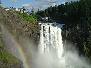
Snoqualmie (pronounced "snow-KWAWL-mee") is a city in King County, Washington, United States. It is located right next to the famous Snoqualmie Falls. The city is about 28 miles (45 km) east of Seattle.
Snoqualmie is home to the Northwest Railway Museum. In 2020, about 14,121 people lived there. You might recognize Snoqualmie from TV! Many outdoor scenes for the show Twin Peaks were filmed here. Some scenes were also filmed in nearby North Bend and Fall City. Famous movie actress Ella Raines was born in Snoqualmie Falls in 1920. This area is now part of Snoqualmie city.
Contents
- What's in a Name? The Meaning of Snoqualmie
- A Look Back: The History of Snoqualmie
- Where is Snoqualmie? Geography and Climate
- Snoqualmie's Economy: How People Make a Living
- Who Lives in Snoqualmie? Population Facts
- City Landmark: Snoqualmie's Historic District
- Friends Around the World: Sister Cities
- See also
What's in a Name? The Meaning of Snoqualmie
The name "Snoqualmie" comes from the Native American tribe who lived here. It's an English version of their word sdukʷalbixʷ. This word means "people of the moon" in the Lushootseed language.
A Look Back: The History of Snoqualmie
The Snoqualmie Valley has been home to the Snoqualmie Tribe for at least 13,000 years. The first written record of explorers in the valley dates back to 1851. Samuel Hancock traveled up the river with the Snoqualmie tribe. They told him the land was called Hyas Kloshe Illahee, meaning "good land."
Early Settlers and Fort Alden
In the 1850s, there was a lot of tension between Native Americans and new settlers. To deal with this, Fort Alden was built in 1856 near a Snoqualmie village. This area later became the city of Snoqualmie. After a conflict called the Treaty War ended, Fort Alden was no longer needed and was left empty.
Jeremiah Borst was a very successful early settler. He arrived in 1858 and bought a lot of land. He sold pigs and apples in Seattle, which helped him buy more land from other settlers.
Logging and Hops: Early Industries
The first lumber mill in the Snoqualmie Valley started around 1872. Within five years, there were 12 logging companies working on the Snoqualmie River. They sent millions of board feet of lumber to Seattle. Logging and mill work employed 140 men within 15 years.
In 1882, a huge hop farm was started on Jeremiah Borst's land. It grew to cover 1,500 acres (6.1 km2), with 900 acres (3.6 km2) just for hops. This farm was known as "The Largest Hop Ranch in the World." However, it became less important by the late 1890s due to market changes and pests.
Railways and City Growth
By the late 1800s, the Puget Sound region was growing fast. But major railways were not reaching it. So, a group of Seattle business people built their own railway. The Seattle, Lake Shore and Eastern Railway opened up the Snoqualmie Valley. It helped send natural resources to markets worldwide. It also brought tourists to see the beautiful area and the amazing Falls.
This new interest led to more people wanting to buy land. The area that is now Snoqualmie was officially planned out in August 1889. The first residents were Edmund and Louisa Kinsey. They opened the first hotel, store, post office, and helped build the first church. Two of their sons became famous photographers, documenting the early timber industry.
Power from the Falls
The Snoqualmie Falls Hydroelectric Plant was built in the late 1890s. It was the first power plant at the Falls. It provided both electricity and jobs to the area. A small town grew up near the falls for the workers. Even today, more than 100 years later, the original generators are still used by Puget Sound Energy.
Snoqualmie officially became a city in 1903. At first, land prices were very high. This led many people to build homes wherever they wanted, even if they didn't own the land. The city council's first job was to lower land prices. They also had to move these buildings to create the town's layout we see today.
Timber and Modern Changes
In 1917, a new, all-electric lumber mill opened across the river. It was only the second one in the U.S. This mill and its company town, Snoqualmie Falls, provided stable jobs for many years. This continued even through World War I and the Great Depression.
However, Snoqualmie's growth slowed down in the mid-1900s. The city was bypassed when a major highway, U.S. Route 10 (now Interstate 90), was built. This shifted business to other towns.
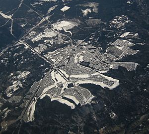
By the 1960s, the homes from the old mill town were moved. The city's population grew slowly for 30 years. This changed in the mid-1990s when Snoqualmie added 1,300 acres (5.3 km2) of undeveloped land. This land became Snoqualmie Ridge, a planned community. It includes homes, a business park, shops, and a private golf course. More land was added in 2004 for more homes and a hospital.
The city council works to keep Snoqualmie's historic and natural feel. At the same time, they meet the needs of a growing population. The historic downtown area has been improved to attract more visitors. Snoqualmie continues to grow with new homes, businesses, and public spaces like parks.
In 2012, Snoqualmie added 593 acres (2.4 km2) of a former mill site. This site is now home to Dirtfish, a school for rally car drivers. It's one of the largest undeveloped industrial areas in King County.
Where is Snoqualmie? Geography and Climate
Snoqualmie is located at 47°31′59″N 121°50′40″W. It sits about 410 feet (125 meters) above sea level.
The city covers a total area of about 6.51 square miles (16.86 km2). Most of this is land (6.40 sq mi or 16.58 km2), with a small amount of water (0.11 sq mi or 0.28 km2).
Neighboring Towns
Snoqualmie is surrounded by other communities:
 |
Fall City |  |
||
| Preston | ||||
| North Bend |
Snoqualmie's Weather
Snoqualmie has a warm-summer Mediterranean climate. This means it has warm, dry summers and mild, wet winters.
| Climate data for Snoqualmie, Washington (1991–2020 normals, extremes 1899–2021) | |||||||||||||
|---|---|---|---|---|---|---|---|---|---|---|---|---|---|
| Month | Jan | Feb | Mar | Apr | May | Jun | Jul | Aug | Sep | Oct | Nov | Dec | Year |
| Record high °F (°C) | 67 (19) |
75 (24) |
81 (27) |
90 (32) |
97 (36) |
114 (46) |
104 (40) |
102 (39) |
98 (37) |
95 (35) |
75 (24) |
67 (19) |
114 (46) |
| Mean maximum °F (°C) | 57.9 (14.4) |
62.9 (17.2) |
69.1 (20.6) |
75.4 (24.1) |
81.7 (27.6) |
85.5 (29.7) |
89.5 (31.9) |
88.2 (31.2) |
84.6 (29.2) |
75.8 (24.3) |
61.8 (16.6) |
57.1 (13.9) |
92.8 (33.8) |
| Mean daily maximum °F (°C) | 46.4 (8.0) |
49.6 (9.8) |
53.7 (12.1) |
58.9 (14.9) |
64.1 (17.8) |
69.0 (20.6) |
75.8 (24.3) |
76.7 (24.8) |
70.4 (21.3) |
59.5 (15.3) |
51.1 (10.6) |
45.8 (7.7) |
60.1 (15.6) |
| Daily mean °F (°C) | 41.1 (5.1) |
42.4 (5.8) |
45.4 (7.4) |
49.5 (9.7) |
55.1 (12.8) |
59.8 (15.4) |
64.9 (18.3) |
65.2 (18.4) |
59.7 (15.4) |
51.5 (10.8) |
44.7 (7.1) |
40.7 (4.8) |
51.7 (10.9) |
| Mean daily minimum °F (°C) | 35.8 (2.1) |
35.3 (1.8) |
37.2 (2.9) |
40.1 (4.5) |
46.1 (7.8) |
50.6 (10.3) |
54.0 (12.2) |
53.7 (12.1) |
49.1 (9.5) |
43.5 (6.4) |
38.3 (3.5) |
35.7 (2.1) |
43.3 (6.3) |
| Mean minimum °F (°C) | 23.1 (−4.9) |
24.2 (−4.3) |
27.6 (−2.4) |
30.4 (−0.9) |
35.1 (1.7) |
42.6 (5.9) |
45.3 (7.4) |
45.6 (7.6) |
39.7 (4.3) |
31.0 (−0.6) |
26.4 (−3.1) |
24.6 (−4.1) |
20.2 (−6.6) |
| Record low °F (°C) | −1 (−18) |
−3 (−19) |
8 (−13) |
24 (−4) |
26 (−3) |
31 (−1) |
36 (2) |
35 (2) |
30 (−1) |
23 (−5) |
2 (−17) |
3 (−16) |
−3 (−19) |
| Average precipitation inches (mm) | 8.64 (219) |
5.83 (148) |
6.74 (171) |
5.29 (134) |
4.04 (103) |
3.15 (80) |
1.24 (31) |
1.22 (31) |
3.02 (77) |
6.22 (158) |
9.47 (241) |
8.42 (214) |
63.28 (1,607) |
| Average snowfall inches (cm) | 1.5 (3.8) |
0.2 (0.51) |
0.3 (0.76) |
0 (0) |
0 (0) |
0 (0) |
0 (0) |
0 (0) |
0 (0) |
0 (0) |
0.1 (0.25) |
1.5 (3.8) |
3.6 (9.1) |
| Average precipitation days (≥ 0.01 in) | 20.8 | 15.1 | 20.3 | 19.1 | 15.1 | 12.5 | 7.0 | 5.8 | 10.0 | 16.1 | 20.5 | 18.9 | 181.2 |
| Average snowy days (≥ 0.1 in) | 0.8 | 0.3 | 0.2 | 0 | 0 | 0 | 0 | 0 | 0 | 0 | 0.2 | 0.8 | 2.3 |
| Source 1: NOAA | |||||||||||||
| Source 2: The Weather Channel | |||||||||||||
Snoqualmie's Economy: How People Make a Living
For a long time, logging and the Weyerhaeuser company's mills were the main jobs in Snoqualmie. Since 1989, the mill has been much smaller, and it closed completely in 2003. Dairy farming was also important until the 1950s, but farming is not a big part of the economy anymore. When Interstate 90 was finished in the 1970s, it became easier to travel to Seattle and the nearby Eastside areas. This meant more residents started working in those cities.
Local Businesses and Tourism
The Snoqualmie Ridge Business Park was built in the 1990s. It has many businesses and employs over a thousand people. Most of these workers live in Snoqualmie. Some major employers include Space Labs, Motion Water Sports, Technical Glass, T-Mobile, Zetec, and King County's environmental department. Philips Oral Healthcare also has many employees in Snoqualmie who make the Sonicare electric toothbrush.
Tourism is also a big part of Snoqualmie's economy. People visit for the beautiful scenery and fun activities. Snoqualmie Falls and the nearby Salish Lodge are very popular. About 1.5 million people visit the Falls each year. The Northwest Railway Museum in downtown Snoqualmie has a historic train station. It offers fun train rides for visitors. The Snoqualmie Indian Tribe owns the Snoqualmie Casino, which opened in 2008 a few miles outside the city.
Who Lives in Snoqualmie? Population Facts
| Historical population | |||
|---|---|---|---|
| Census | Pop. | %± | |
| 1910 | 279 | — | |
| 1920 | 450 | 61.3% | |
| 1930 | 752 | 67.1% | |
| 1940 | 775 | 3.1% | |
| 1950 | 806 | 4.0% | |
| 1960 | 1,216 | 50.9% | |
| 1970 | 1,260 | 3.6% | |
| 1980 | 1,370 | 8.7% | |
| 1990 | 1,546 | 12.8% | |
| 2000 | 1,631 | 5.5% | |
| 2010 | 10,670 | 554.2% | |
| 2020 | 14,121 | 32.3% | |
| 2021 (est.) | 13,810 | 29.4% | |
| U.S. Decennial Census 2018 Estimate |
|||
In 2010, there were 10,670 people living in Snoqualmie. There were 3,547 households, and 2,912 families. The city had about 1,667 people per square mile (644 per km2).
Population Details from 2010
- About 35% of residents were under 18 years old.
- About 39% were between 25 and 44 years old.
- The average household had about 3 people.
- The average family had about 3.3 people.
- The median age in the city was 33.7 years old.
- The population was split almost evenly between males (50%) and females (50%).
Diversity in Snoqualmie
In 2010, the racial makeup of the city was:
- 83.3% White
- 0.8% African American
- 0.9% Native American
- 9.3% Asian
- 0.1% Pacific Islander
- 1.4% from other races
- 4.4% from two or more races
- Hispanic or Latino people made up 5.3% of the population.
City Landmark: Snoqualmie's Historic District
The city of Snoqualmie has named one special area as a landmark:
| Landmark | Built | Listed | Address | Photo |
|---|---|---|---|---|
| Snoqualmie Historic Commercial District | 1889–1941 | 1997 | Railroad Avenue vicinity |  |
Friends Around the World: Sister Cities
Snoqualmie has "sister cities" in other countries. These partnerships help build cultural ties and understanding.
- Gangjin, South Korea
- Chaclacayo, Peru
See also
 In Spanish: Snoqualmie (Washington) para niños
 | Precious Adams |
 | Lauren Anderson |
 | Janet Collins |


