
Snoqualmie Pass facts for kids
Quick facts for kids Snoqualmie Pass |
|
|---|---|

I-90 through Snoqualmie Pass
|
|
| Elevation | 3,015 ft (919 m) |
| Traversed by | |
| Location | King / Kittitas counties, Washington, U.S. |
| Range | Cascade Range |
| Coordinates | 47°25′23″N 121°24′40″W / 47.423°N 121.411°W |

Snoqualmie Pass
Location in Washington (state)

Snoqualmie Pass
Location in the United States
|
|
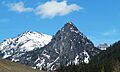
Snoqualmie Pass is a mountain pass in the Cascade Range in Washington. It carries Interstate 90 (I-90) over the mountains. The highest point of the pass is at an elevation of about 3,015 feet (921 meters). This spot is on the border between Kittitas County and King County.
Snoqualmie Pass is special because it's the lowest of the three main routes across Washington State. These routes stay open all year. The other two are Stevens Pass to the north and White Pass to the south. I-90 is a very important road for trade. It connects Seattle with places to the east. About 29,000 vehicles use the pass every day. It is also the only divided highway that crosses the state from east to west.
The pass gives its name to a small community right at the top. This community is called Snoqualmie Pass, Washington. Both the community and the pass are named after the Snoqualmie people. They are a Native American tribe from the valley to the west.
Contents
Weather at Snoqualmie Pass
As you go up into the Cascades, the weather at Snoqualmie Pass changes a lot. It has a special climate with a lot of rain and snow. This can make travel tricky sometimes. On average, the pass gets over 100 inches of rain each year. It also gets more than 400 inches of snow! There are over 170 days a year with some rain or snow.
| Climate data for Snoqualmie Pass | |||||||||||||
|---|---|---|---|---|---|---|---|---|---|---|---|---|---|
| Month | Jan | Feb | Mar | Apr | May | Jun | Jul | Aug | Sep | Oct | Nov | Dec | Year |
| Record high °F (°C) | 56 (13) |
61 (16) |
67 (19) |
81 (27) |
84 (29) |
94 (34) |
101 (38) |
101 (38) |
101 (38) |
88 (31) |
65 (18) |
53 (12) |
101 (38) |
| Mean daily maximum °F (°C) | 32.4 (0.2) |
37.1 (2.8) |
42.1 (5.6) |
48.9 (9.4) |
56.3 (13.5) |
62.9 (17.2) |
70.3 (21.3) |
69.3 (20.7) |
63.9 (17.7) |
53.8 (12.1) |
39.9 (4.4) |
33.7 (0.9) |
50.9 (10.5) |
| Mean daily minimum °F (°C) | 20.9 (−6.2) |
23.3 (−4.8) |
26.0 (−3.3) |
30.0 (−1.1) |
34.2 (1.2) |
40.0 (4.4) |
45.6 (7.6) |
45.7 (7.6) |
41.1 (5.1) |
35.0 (1.7) |
28.2 (−2.1) |
23.5 (−4.7) |
32.8 (0.4) |
| Record low °F (°C) | −17 (−27) |
−15 (−26) |
0 (−18) |
7 (−14) |
21 (−6) |
27 (−3) |
31 (−1) |
27 (−3) |
22 (−6) |
11 (−12) |
0 (−18) |
−19 (−28) |
−19 (−28) |
| Average precipitation inches (mm) | 15.69 (399) |
11.89 (302) |
10.65 (271) |
5.99 (152) |
3.87 (98) |
3.74 (95) |
1.38 (35) |
2.23 (57) |
4.51 (115) |
9.32 (237) |
13.59 (345) |
17.17 (436) |
100.05 (2,541) |
| Average snowfall inches (cm) | 104.4 (265) |
75.3 (191) |
69.6 (177) |
25.8 (66) |
5.5 (14) |
0.3 (0.76) |
0.1 (0.25) |
0.0 (0.0) |
0.2 (0.51) |
7.4 (19) |
44.6 (113) |
86.9 (221) |
420.1 (1,067.52) |
How Does Weather Affect Travel?
Because the weather changes so quickly, drivers need to be careful. Signs along I-90 tell drivers what to do. Sometimes, they need to put tire chains on their tires. This is often for big trucks, but sometimes for cars too. There are special areas on the side of the road to put on chains. The pass has to close sometimes when the weather gets too bad.
Years ago, there was a special tunnel-like structure called a snow shed. It covered the road to protect it from snow and avalanches. This was built in 1950. Now, there are special bridges that let avalanches pass underneath the road. This helps keep the road clear and safe.
The WSDOT has cameras along the pass. They use these cameras to watch the weather. You can even see some of these camera views online!
Fun Things to Do at Snoqualmie Pass

The area around Snoqualmie Pass has many mountain cabins. Most of these are used by people from Seattle for vacations. About 150 people live there all year. Winter sports are very popular here. But you can find fun outdoor activities all year long.
Hiking and Skiing
The Pacific Crest Trail goes right through Snoqualmie Pass. Many other trails are great for hiking and climbing in the summer. In winter, these trails are perfect for cross-country skiing and snowshoeing.
Snoqualmie Pass is also home to The Summit at Snoqualmie. This is a group of ski areas. Boyne USA Resorts manages them. The Summit has four main ski areas: Alpental, Summit West, Summit Central, and Summit East. The Summit at Snoqualmie is the closest ski area to Seattle.
Other Outdoor Activities
Snowmobiling is also popular just east of the pass in winter. In the summer and fall, you might see paragliders and hang gliders flying high above the valley. They often land near Lake Keechelus.
History of Snoqualmie Pass


Native Americans in the region knew about Snoqualmie Pass for a long time. Fur traders from the Hudson's Bay Company were in the area in the early 1800s. They knew about the pass, but we don't have many details about how they used it.
In 1853 and 1854, Captain George B. McClellan and his team explored the Snoqualmie Pass area. They were looking for a good place for a railroad. In 1856, Major J.H.H. Van Bokkelen crossed the pass on a scouting trip. By 1858, many large groups of people with supplies crossed the pass. They were going to mines east of the mountains.
Building Roads and Railways
In 1865, some people from Seattle explored the area. They decided that Snoqualmie Pass was a better place for a road than the old Native American trail. By 1867, a toll road was built over the pass. It was meant for wagons, but for many years, only pack animals and cattle could use it.
The Chicago, Milwaukee, St. Paul and Pacific Railroad built a train line through Snoqualmie Pass in 1909. This was part of their big expansion. In 1914, they built the 2¼-mile (3.6 km) Snoqualmie Tunnel. This tunnel was about 400 feet (120 meters) below the pass. The train line was closed in 1980. Now, the tunnel is a path for bikes and hikers, part of Iron Horse State Park.
While the tunnel was being built, a better wagon road was made over the pass. The Sunset Highway opened through the pass in 1915. In 1927, this road became U.S. Route 10. In 1931, they started plowing the road to keep it open in winter. The first ski hill at Snoqualmie Pass opened in 1933. U.S. 10 was finally paved in 1934.
In 1969, work began on Interstate 90 across the pass. This new highway replaced U.S. 10. Since 1991, the Mountains to Sound Greenway Trust has worked to protect the beautiful views along the I-90 route over Snoqualmie Pass.
Images for kids
-
Snoqualmie Pass landmarks

