Carnation, Washington facts for kids
Quick facts for kids
Carnation, Washington
tultxʷ
|
||
|---|---|---|

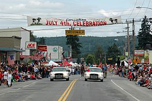
Carnation, Washington. July 4, 2004
|
||
|
||

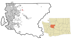
Location of Carnation, Washington
|
||
| Country | United States | |
| State | Washington | |
| County | King | |
| Government | ||
| • Type | Council–manager | |
| Area | ||
| • Total | 1.18 sq mi (3.07 km2) | |
| • Land | 1.16 sq mi (3.00 km2) | |
| • Water | 0.03 sq mi (0.07 km2) | |
| Elevation | 82 ft (25 m) | |
| Population
(2020)
|
||
| • Total | 2,158 | |
| • Density | 1,970.64/sq mi (761.00/km2) | |
| Time zone | UTC-8 (Pacific (PST)) | |
| • Summer (DST) | UTC-7 (PDT) | |
| ZIP code |
98014
|
|
| Area code(s) | 425 | |
| FIPS code | 53-10215 | |
| GNIS feature ID | 1530825 | |
Carnation (which is called tultxʷ in the Lushootseed language) is a city in King County, Washington, United States. It used to be known as Tolt. The city is located where the Snoqualmie and Tolt rivers meet.
Carnation is east of Redmond and south of Duvall. You can find it along State Route 203. In 2020, about 2,158 people lived there. Before American settlers arrived, the area was home to a large village of the Snoqualmie people. It was a very important place for the Snoqualmie in the 1800s.
After the Snoqualmie people moved to reservations, Americans settled the area. They founded the town of Tolt in 1865. In the 1900s, it became a busy dairy farming town. It was later renamed Carnation to honor the Carnation Evaporated Milk Company. The name changed back and forth a couple of times, but Carnation eventually stuck. Since the 1990s, Carnation has become a "bedroom community." This means many people who live there travel to nearby cities like Seattle for work.
Contents
History of Carnation, Washington
Early Snoqualmie Settlement
The Snoqualmie people have lived in the Carnation area for over 10,000 years. Before American settlers came, the Snoqualmie had a large village. This village was located where the Tolt River meets the Snoqualmie River. It was the second-largest village in the Snoqualmie river valley. This village also had the best natural defenses in the valley.
The most important building in the village was called the x̌alalʔtxʷ (pronounced "ha-lal-tkhw"). This means "marked house." The x̌alalʔtxʷ was a huge longhouse. It worked like a main government building. Important meetings were held there by local elders and visiting leaders. It was also a learning center for everyone in the Snoqualmie valley. Elders taught valuable skills and knowledge. This included the Snoqualmie language, their customs, and their laws.
In the 1800s, a famous Snoqualmie leader named Patkanim was born in this village. During this time, the Snoqualmie society started to become more organized. It became a "chiefdom," which is a type of government led by a chief. The village served as the main capital of the Snoqualmie chiefdom under Patkanim.
American Settlement and Name Changes
American settlers began moving into the Snoqualmie Valley in the 1850s and 1860s. This happened after the 1855 Treaty of Point Elliot was signed. Many Snoqualmie people moved to reservations like Tulalip. The community of Tolt was started in 1865. It was officially mapped out in 1902. The name "Tolt" came from an English version of the Lushootseed name for the Tolt River. The Snoqualmie village also had a similar name.
Tolt officially became a town on December 30, 1912. This happened shortly after the Milwaukee Road train line arrived. The train connected Tolt to Monroe in the north.
The valley became home to many dairy farms in the early 1900s. One of these was a research farm for the Carnation Evaporated Milk Company. The company asked the state to change the town's name. With approval from the state legislature, Tolt was renamed "Carnation" in 1917. However, many local residents and members of the Snoqualmie Indian Tribe did not like the name change. So, on May 3, 1928, the name was changed back to Tolt.
Even so, the "Carnation" name stayed on the post office and train depot. People from outside the town kept using the name Carnation. Because of this, Tolt was renamed "Carnation" again on October 29, 1951. In the late 1900s, Carnation changed from dairy farming. It became a place where people lived and commuted to jobs in the Eastside area. By 2020, its population had grown to 2,158 people.
Geography and Climate
Where is Carnation Located?
Carnation is in the Snoqualmie Valley. It sits between the towns of Duvall and Fall City. The city is on the east side of the Snoqualmie River. It's just north of where the Snoqualmie River meets the Tolt River.
The United States Census Bureau says the city covers about 1.18 square miles (3.07 square kilometers). Most of this area, about 1.16 square miles (3.00 square kilometers), is land. A small part, about 0.02 square miles (0.07 square kilometers), is water. Langlois Lake is located just outside the city limits.
Carnation's Climate
Carnation has a type of weather called a warm-summer mediterranean climate. This means it has warm, dry summers and mild, wet winters.
| Climate data for Carnation | |||||||||||||
|---|---|---|---|---|---|---|---|---|---|---|---|---|---|
| Month | Jan | Feb | Mar | Apr | May | Jun | Jul | Aug | Sep | Oct | Nov | Dec | Year |
| Record high °F (°C) | 58 (14) |
64 (18) |
68 (20) |
85 (29) |
88 (31) |
107 (42) |
100 (38) |
99 (37) |
91 (33) |
79 (26) |
69 (21) |
60 (16) |
107 (42) |
| Mean maximum °F (°C) | 52.0 (11.1) |
53.3 (11.8) |
60.0 (15.6) |
69.9 (21.1) |
80.2 (26.8) |
83.6 (28.7) |
88.8 (31.6) |
91.0 (32.8) |
83.1 (28.4) |
68.7 (20.4) |
58.9 (14.9) |
51.5 (10.8) |
92.9 (33.8) |
| Mean minimum °F (°C) | 24.0 (−4.4) |
22.1 (−5.5) |
26.8 (−2.9) |
31.4 (−0.3) |
36.6 (2.6) |
41.4 (5.2) |
47.2 (8.4) |
48.3 (9.1) |
41.5 (5.3) |
34.7 (1.5) |
25.1 (−3.8) |
21.8 (−5.7) |
15.5 (−9.2) |
| Record low °F (°C) | 6 (−14) |
12 (−11) |
22 (−6) |
28 (−2) |
28 (−2) |
35 (2) |
38 (3) |
41 (5) |
30 (−1) |
23 (−5) |
5 (−15) |
8 (−13) |
5 (−15) |
| Average precipitation inches (mm) | 4.41 (112) |
3.09 (78) |
3.26 (83) |
2.2 (56) |
1.56 (40) |
1.07 (27) |
0.39 (9.9) |
0.57 (14) |
1.28 (33) |
3.05 (77) |
5.1 (130) |
4.86 (123) |
30.84 (782.9) |
| Source 1: National Weather Service | |||||||||||||
| Source 2: for precipitation data | |||||||||||||
Fun Places to Visit in Carnation
Local Attractions and Farms
Camlann Medieval Village is a special place located about 4 miles (6.4 km) north of Carnation. It's a living history museum that shows what life was like in an English village in the year 1376. Camlann was started in the early 1980s. Its goal is to teach and entertain schools, clubs, families, and individuals about medieval times.
Remlinger Farms is a real farm located less than 1 mile (1.6 km) outside the center of Carnation. Families can visit to see crops, eat food grown right there, and even go on fun park rides.
People and Population (Demographics)
Carnation's Population Over Time
| Historical population | |||
|---|---|---|---|
| Census | Pop. | %± | |
| 1920 | 536 | — | |
| 1930 | 360 | −32.8% | |
| 1940 | 460 | 27.8% | |
| 1950 | 446 | −3.0% | |
| 1960 | 490 | 9.9% | |
| 1970 | 530 | 8.2% | |
| 1980 | 913 | 72.3% | |
| 1990 | 1,243 | 36.1% | |
| 2000 | 1,893 | 52.3% | |
| 2010 | 1,786 | −5.7% | |
| 2020 | 2,158 | 20.8% | |
| U.S. Decennial Census 2020 Census |
|||
Demographics is the study of a population, like how many people live somewhere and what groups they belong to. According to the 2010 census, there were 1,786 people living in Carnation. These people lived in 631 households, with 474 of them being families. The city had about 1,540 people per square mile (594 people per square kilometer).
Most of the people in Carnation were White (85.8%). Other groups included African American (0.9%), Native American (1.0%), and Asian (3.1%). About 12.7% of the population was Hispanic or Latino.
In 45% of the households, there were children under 18 years old. About 58.5% of households were married couples living together. The average household had 2.83 people, and the average family had 3.24 people.
The average age of people in Carnation was 34.9 years old. About 30.1% of residents were under 18. About 6% were 65 or older. The population was almost evenly split between males (49.8%) and females (50.2%).
Carnation has a high rate of home ownership compared to other cities in King County. About 73.31% of homes in Carnation are owned by the people who live in them. This is much higher than in nearby cities like Redmond (50.19%), Bellevue (53.78%), and Seattle (44.91%).
Schools in Carnation
Learning in the Riverview School District
Carnation is part of the Riverview School District. This district has several schools for students of different ages:
- Carnation Elementary and PARADE Program: Located in Carnation, Washington at 32239 E. Morrison St.
- Cherry Valley Elementary: Located in Duvall, Washington.
- Stillwater Elementary: Located between Carnation and Duvall.
- Eagle Rock Multi-Age: Located in Duvall.
- Tolt Middle School: Located in Carnation.
- Cedarcrest High School: Located in Duvall.
City Landmarks
Historic Buildings in Carnation
The City of Carnation has officially recognized these buildings as important landmarks:
| Landmark | Built | Listed | Address | Photo |
|---|---|---|---|---|
| Commercial Hotel | 1913 | 1996 | 31933 W. Rutherford Street | |
| Entwistle House | 1912 | 1994 | 32021 Entwistle Street | |
| Tolt IOOF/Eagles Hall | 1895 | 1994 | 3940 Tolt Avenue, Carnation |
See also
 In Spanish: Carnation (Washington) para niños
 | Bessie Coleman |
 | Spann Watson |
 | Jill E. Brown |
 | Sherman W. White |


