
Skykomish Peak facts for kids
Quick facts for kids Skykomish Peak |
|
|---|---|

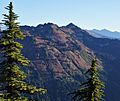
Skykomish Peak, north aspect
|
|
| Highest point | |
| Elevation | 6,368 ft (1,941 m) |
| Prominence | 768 ft (234 m) |
| Isolation | 2.03 mi (3.27 km) |
| Parent peak | Johnson Mountain (6,721 ft) |
| Geography | |

Skykomish Peak
Location in Washington (state)

Skykomish Peak
Location in the United States
|
|
| Location | Snohomish / Chelan counties Washington state, U.S. |
| Parent range | North Cascades Cascade Range |
| Topo map | USGS Benchmark Mountain |
| Climbing | |
| Easiest route | class 2 Hiking Southeast Ridge |
Skykomish Peak is a tall mountain in the North Cascades of Washington state. It stands at 6,368 feet (1,941 meters) high. This peak is found in the beautiful Henry M. Jackson Wilderness.
The mountain sits right on the edge of the Cascade Range. It is on the border between Snohomish and Chelan counties. It also divides the Mount Baker-Snoqualmie National Forest and the Okanogan-Wenatchee National Forest.
Skykomish Peak is about 15 miles (24 km) north of Stevens Pass. The famous Pacific Crest Trail goes along the east side of the peak. Water from the mountain flows into the Skykomish River to the west. To the east, it flows into Cady Creek, which joins the Little Wenatchee River.
The mountain gets its name from its location at the start of the North Fork Skykomish River. The word "Skykomish" comes from the Lushootseed language. It means "upriver people."
How Mountains Formed: Geology of Skykomish Peak
The North Cascades area has very rugged land. You can see sharp peaks, tall spires, and deep valleys carved by glaciers. These amazing shapes were created by geological events over millions of years.

The Cascade Mountains began to form a very long time ago. This was during the late Eocene Epoch. The Earth's large plates were moving. The North American Plate was pushing over the Pacific Plate. This caused many volcanoes to erupt.
Glacier Peak is a large, cone-shaped volcano. It is about 11 miles (18 km) north of Skykomish Peak. Glacier Peak started forming about 2 million years ago. Because it is so close, volcanic ash is common around Skykomish Peak. This ash makes the soil rich. It helps many wildflowers grow on the mountain's slopes.
About two million years ago, during the Pleistocene period, glaciers covered the land. These huge ice sheets moved forward and then melted back many times. As they moved, they scraped the land. They left behind piles of rocks and dirt. The "U"-shaped valleys you see today were carved by these ancient glaciers.
The land was also pushed up and broken by faults. This, along with the glaciers, created the tall peaks and deep valleys of the North Cascades.
Mountain Weather: Climate Around Skykomish Peak
Skykomish Peak is in a "marine west coast" climate zone. This means it gets a lot of moisture from the Pacific Ocean. Most weather systems start over the Pacific. They then move northeast toward the Cascade Mountains.
When these weather systems reach the North Cascades, the tall peaks force the air upward. As the air rises, it cools. This makes it drop its moisture as rain or snow. This process is called "orographic lift." Because of this, the western side of the North Cascades gets a lot of rain and snow. This is especially true in winter.
The snow here tends to be wet and heavy. This can create a risk of avalanches. The climate is mild because it's close to the ocean. Temperatures rarely go below 0°F (-18°C) or above 80°F (27°C).
In winter, the weather is often cloudy. But in summer, high-pressure systems over the Pacific Ocean bring clear skies. The best time to visit or climb Skykomish Peak is from July to September. The weather is usually sunny and pleasant then.
Images for kids
-
West aspect

