Skokomish River facts for kids
Quick facts for kids Skokomish River |
|
|---|---|

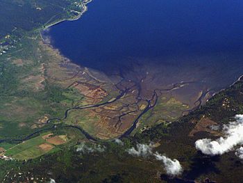
Skokomish River Delta on Hood Canal
|
|
| Country | United States |
| Physical characteristics | |
| Main source | Mount Skokomish, Olympic Mountains (North Fork); Sundown Pass, Olympic Mountains (South Fork) |
| River mouth | Hood Canal sea level |
| Length | 69 km (43 mi) |
| Basin features | |
| Basin size | 588 km2 (227 sq mi) |
The Skokomish River is an important river in Mason County, Washington, United States. It's the biggest river that flows into Hood Canal, which is an arm of Puget Sound. The main part of the Skokomish River is about 9 miles (14 km) long. But if you count its longest branch, the South Fork, the whole river system is about 49 miles (79 km) long! A big part of the Skokomish River's watershed is inside Olympic National Forest and Olympic National Park.
Contents
Where the Skokomish River Flows
The Skokomish River and its two main branches, called forks, drain the southeast part of the Olympic Mountains. This area is mostly in Mason County.
The Main River Channel
The main Skokomish River starts when its North Fork and South Fork join together. This happens near a small community called Mohrweis. From there, the river flows east through the wide Skokomish Valley.
It then goes under U.S. Route 101 and turns northeast. Near its end, Washington State Route 106 crosses the river. The Skokomish River flows into Annas Bay at Hood Canal, creating a large estuary called Skokomish Flats. The lower part of the river flows along the Skokomish Indian Reservation.
The South Fork Skokomish River
The South Fork Skokomish River begins high up in Olympic National Park. It starts near Sundown Pass. This area is also close to where other rivers like the Wynoochee River begin.
The South Fork flows southeast out of the national park. It then travels between Capitol Peak and Wonder Mountain. Many smaller streams join the South Fork, including Pine Creek and Cedar Creek. The South Fork then leaves the mountains and flows through some gorges before reaching the wide Skokomish Valley. Here, it meets the North Fork to form the main Skokomish River.
The North Fork Skokomish River
The North Fork Skokomish River starts on the northern slopes of Mount Skokomish. It flows west into Olympic National Park. The valley of the North Fork is a popular place for hiking trails in the park.
The river turns south, then southeast, and many smaller streams join it. The North Fork rushes over Staircase Rapids, which is a beautiful spot near Staircase Campground. This area is a main entrance to the southeast part of Olympic National Park.
The river then flows into Lake Cushman, which is a reservoir. This lake was made to help provide electricity to Tacoma. The North Fork leaves Lake Cushman and flows a short distance to another reservoir, Lake Kokanee. From there, it flows south into the Skokomish Valley to join the South Fork. Lake Cushman and Lake Kokanee are held back by Cushman Dam No. 1 and Cushman Dam No. 2.
For a long time, almost all the water from the North Fork was sent through the dams. But in 2009, an agreement was made between Tacoma Power, the Skokomish Tribe, and government agencies. Now, more water is released into the North Fork below the dams. This helps the river flow more naturally.
Skokomish River History
Before the Cushman Hydroelectric Project was built, the Skokomish River was very important for salmon. It was the biggest and most productive river for salmon in the Hood Canal area of Puget Sound.
The name "Skokomish" comes from the language of the Twana people. It means "river people" or "people of the river." The Skokomish were one of the largest groups of Twana people who lived in this area long ago.
The area around the South Fork of the river was heavily logged in the past. However, logging has been greatly reduced in the Olympic National Forest since the late 1980s.
Flooding Challenges
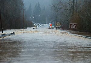
The Skokomish River is known for flooding very often in Washington State. It's often the first river to flood when there's a lot of rain. On December 3, 2007, it had its highest flood level ever recorded. This happened after a strong tropical rainstorm.
The flood in 2007 was so big that it damaged Highway 101. The highway had to be closed for two days for emergency repairs. Because of this, officials decided to build a new, higher road structure over the lowest part of the valley where Highway 101 crosses. A new bridge, 350 feet long and 12 feet higher than the old road, opened in 2009.
Another big flood in 1996 closed both U.S. Route 101 and State Route 106 for four days. These floods often bring news crews to the area.
Several things are thought to cause the frequent flooding. These include more sediment in the river from past logging and less space for sediment because of the dams on the North Fork. Also, winter rainstorms often bring the most rain to the Skokomish River area.
The Skokomish Tribe has worked on restoring the Skokomish delta. This project has helped reduce flooding in the valley. Even during a very high flood event after the restoration, the flooding was much less severe than it would have been before. Some scientists also think that the land around the lower Skokomish River might be slowly rising. This could also make flooding worse by making the river flow slower.
 | James B. Knighten |
 | Azellia White |
 | Willa Brown |


