
Monte Cristo Peak facts for kids
Quick facts for kids Monte Cristo Peak |
|
|---|---|

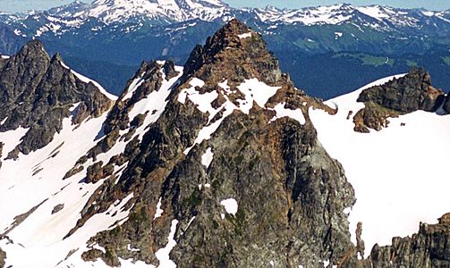
Northwest aspect from Glacier Basin
|
|
| Highest point | |
| Elevation | 7,136 ft (2,175 m) NGVD 29 |
| Prominence | 576 ft (176 m) |
| Parent peak | Kyes Peak |
| Geography | |

Monte Cristo Peak
Location in Washington (state)

Monte Cristo Peak
Location in the United States
|
|
| Parent range | Cascade Range |
| Topo map | USGS Blanca Lake |
| Climbing | |
| First ascent | 1923 by James M. Keyes and W. Zerum |
Monte Cristo Peak is a mountain in the Henry M. Jackson Wilderness in Washington state. It stands tall with Columbia Peak and Kyes Peak. Together, these mountains form a natural bowl that holds the Columbia Glacier and Blanca Lake. In 1918, a magazine called The Mountaineer described Monte Cristo Peak as "a huge pile of red rock."
The mountain gets its name from the old mining town of Monte Cristo. This town was a busy place for mining in the late 1800s and early 1900s. It sits on the northwest side of the mountain. For a few years, the famous businessman J. D. Rockefeller even owned the town! A special railroad and a cable tramway were built to help move mining materials around.
Contents
Weather at Monte Cristo Peak
Monte Cristo Peak is in a "marine west coast" climate zone. This means it gets a lot of weather from the Pacific Ocean. Most weather systems travel from the Pacific Ocean towards the Cascade Mountains.
How Mountains Affect Weather
When these weather systems reach the tall peaks of the Cascade Range, they are forced to rise. As the air goes higher, it cools down. This cooling causes the moisture in the air to turn into rain or snow. This process is called Orographic lift. Because of this, the western side of the North Cascades gets a lot of rain and snow, especially in winter.
Temperatures and Snow
Thanks to the ocean's influence, temperatures here rarely go below 0°F (about -18°C) or above 80°F (about 27°C). Winters are often cloudy. However, during summer, high-pressure systems over the Pacific Ocean usually bring clear skies. The snow in this area tends to be wet and heavy. This can sometimes lead to a high risk of avalanches.
How Monte Cristo Peak Was Formed
The North Cascades area, where Monte Cristo Peak is located, has very rugged land. You can see sharp peaks, long ridges, and deep valleys carved by glaciers. These amazing shapes were created by geological events that happened millions of years ago. These events also caused big changes in elevation, which led to different climates and types of plants in the area.
Ancient Earth Movements
The Cascade Mountains started forming millions of years ago, during the late Eocene Epoch. At that time, the North American Plate (a huge piece of Earth's crust) was slowly moving over the Pacific Plate. This movement caused many volcanic eruptions. For example, Glacier Peak, a large volcano, began forming about 14 miles (23 km) northeast of Monte Cristo Peak during the mid-Pleistocene period.
Building the Mountains
Also, about 50 million years ago, small pieces of Earth's crust called terranes came together to form the North Cascades. These pieces were once part of the ocean floor or other continents.
The Work of Glaciers
During the Pleistocene period, which started over two million years ago, huge sheets of ice called glaciers moved across the land many times. As they moved, they scraped away rock and left behind debris. The U-shaped valleys you see in the rivers today are a result of these glaciers. The combination of land being pushed upward (uplift) and cracks forming in the Earth's crust (faulting), along with the glaciers, created the tall peaks and deep valleys of the North Cascades.
Gallery
-
Monte Cristo Peak from Columbia Peak
-
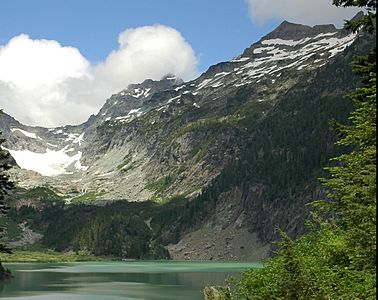
Monte Cristo Peak with Kyes Peak to the right from Blanca Lake


