
Columbia Peak facts for kids
Quick facts for kids Columbia Peak |
|
|---|---|

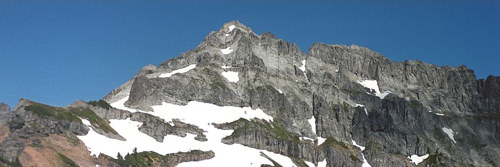
This image shows Columbia Peak on the left, and Columbia Glacier on the right with Blanca Lake in the foreground, looking North.
|
|
| Highest point | |
| Elevation | 7,172 ft (2,186 m) NGVD 29 |
| Prominence | 1,132 ft (345 m) |
| Isolation | 1.30 mi (2.09 km) |
| Parent peak | Kyes Peak |
| Geography | |

Columbia Peak
Location in Washington (state)

Columbia Peak
Location in the United States
|
|
| Location | Snohomish County, Washington, U.S. |
| Parent range | Cascade Range |
| Topo map | USGS Blanca Lake |
| Climbing | |
| Easiest route | class 3 scrambling |
Columbia Peak is a tall mountain found in the Henry M. Jackson Wilderness in Washington, USA. This peak stands at about 7,172 feet (2,186 meters) high. It is part of a special area that also includes Monte Cristo Peak and Kyes Peak. Together, these mountains create a natural bowl. This bowl holds the Columbia Glacier and the beautiful Blanca Lake.
What is the Climate Like on Columbia Peak?
Columbia Peak is in a "marine west coast" climate zone. This means it gets a lot of moisture from the nearby Pacific Ocean. Most weather systems start over the Pacific. They then move northeast towards the Cascade Mountains.
When these weather systems hit the tall Cascade peaks, they are forced to rise. As the air rises, it cools down. This cooling causes the moisture in the air to turn into rain or snow. This process is called orographic lift.
Because of this, the western side of the North Cascades gets a lot of rain and snow. Winter months see especially heavy snowfall. The snow here tends to be wet and heavy. This can create a high risk of avalanches.
Thanks to the ocean's influence, temperatures rarely go below 0°F (-18°C) or above 80°F (27°C). Winters are usually cloudy. However, high pressure systems over the Pacific often bring clear skies in the summer. The best time to visit or climb Columbia Peak is from July to September.
How Did Columbia Peak Form?
The North Cascades mountains have very rugged shapes. They feature sharp peaks, long ridges, and deep valleys carved by glaciers. These different shapes and huge changes in height happened over millions of years. They also led to the different climates we see today.
The Cascade Mountains began forming millions of years ago. This was during a time called the late Eocene Epoch. The North American Plate (a huge piece of Earth's crust) was slowly moving over the Pacific Plate. This movement caused many volcanic eruptions.
Also, small pieces of Earth's crust, called terranes, joined together. These terranes helped create the North Cascades about 50 million years ago.
Later, during the Pleistocene period (over two million years ago), glaciers played a big role. Huge sheets of ice moved forward and backward many times. They scraped and shaped the land, leaving behind rock debris. The "U"-shaped valleys you see today were carved by these glaciers.
The main forces that created the tall peaks and deep valleys of the North Cascades were:
- Uplift: When land is pushed up.
- Faulting: When cracks in the Earth's crust cause sections to move.
- Glaciation: The action of ice sheets and glaciers.
Gallery
-
West aspect, from Twin Lakes

