Kyes Peak facts for kids
Quick facts for kids Kyes Peak |
|
|---|---|

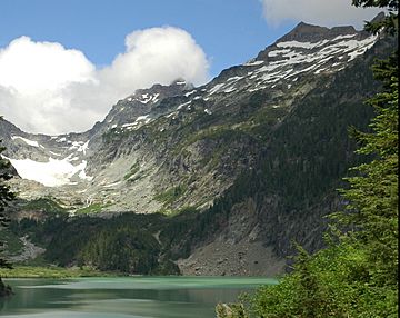
Blanca Lake with Columbia Glacier in the left background, Monte Cristo Peak in the middle background, and Kyes Peak in the right background, looking North.
|
|
| Highest point | |
| Elevation | 7,280+ ft (2,220+ m) NGVD 29 |
| Prominence | 1,720 ft (520 m) |
| Geography | |
| Parent range | Cascade Range |
| Topo map | United States Geological Survey Blanca Lake |
Kyes Peak, sometimes called "Goblin Peak," is a mountain found in the Henry M. Jackson Wilderness in Washington, United States. This peak stands over 7,280 feet (2,219 meters) tall. Kyes Peak, along with Columbia Peak and Monte Cristo Peak, forms a natural bowl. This bowl holds the Columbia Glacier and Blanca Lake. Kyes Peak is the highest point in the group of mountains known as the Monte Cristo peaks.
Kyes Peak was once marked on maps as Goblin Peak. Even earlier, miners and the United States Forest Service called it Mount Michigan. The name Kyes comes from Commander James Ellsworth Kyes. He was part of the first group to climb the mountain. Along with Reginald Bachelder, Kyes reached the top on August 15, 1920. Both were members of the Everett Boy Scouts at that time.
It's not common for a mountain in the Washington Cascades to be named after someone who climbed it. The USGS later agreed to rename the mountain after Kyes. This was to honor his bravery and service. He commanded a destroyer during the Battle of the Atlantic in World War II. An earlier climb of the peak was likely made by Thomas Gerdine of the USGS in 1897.
Mountain Weather: Kyes Peak's Climate
Kyes Peak is located in a "marine west coast" climate zone. This means it gets a lot of influence from the ocean. Most weather systems start over the Pacific Ocean. They then move northeast towards the Cascade Mountains.
When these weather systems reach the North Cascades, the tall mountains force the air upwards. This process is called Orographic lift. As the air rises, it cools and drops its moisture. This moisture falls as rain or snowfall on the Cascades. Because of this, the western side of the North Cascades gets a lot of rain and snow. This is especially true during the winter months.
In winter, the weather is often cloudy. However, in summer, high-pressure systems over the Pacific Ocean become stronger. This often leads to clear skies with little or no clouds. Because the ocean influences the weather, the snow tends to be wet and heavy. This type of snow can increase the risk of avalanches.
How Kyes Peak Was Formed: Geology
The North Cascades mountains have very rugged shapes. You can see sharp peaks, tall spires, long ridges, and deep valleys carved by glaciers. These different shapes and big changes in height were created by geological events. These events happened millions of years ago. They also led to the different climates found across the Cascade Range.
The Cascade Mountains began forming millions of years ago. This was during a time called the late Eocene Epoch. The North American Plate was slowly moving over the Pacific Plate. This movement caused many periods of volcanic activity. Also, small pieces of the Earth's crust, called terranes, came together. These pieces formed the North Cascades about 50 million years ago.
During the Pleistocene period, which started over two million years ago, glaciers played a big role. Huge sheets of ice moved forward and then melted back many times. As they moved, they scraped and shaped the land. They left behind piles of rock and dirt. The river valleys in this area have a "U" shape. This shape is a direct result of these recent glaciers. The lifting of the land and faults, along with glaciation, have been the main forces. These forces created the tall peaks and deep valleys we see in the North Cascades today.
 | Leon Lynch |
 | Milton P. Webster |
 | Ferdinand Smith |


